Sierra de San Just

Last updated
Sierra de San Just
Sierra de San Just69.JPG
Western end of Sierra de San Just near Montalbán
Highest point
Peak San Just
Elevation 1,522 m (4,993 ft)
Listing Mountains of Aragon
Coordinates 40°44′36″N0°39′46″W / 40.74333°N 0.66278°W / 40.74333; -0.66278 Coordinates: 40°44′36″N0°39′46″W / 40.74333°N 0.66278°W / 40.74333; -0.66278
Geography
Relief Map of Spain.png
Red triangle with thick white border.svg
Sierra de San Just
Location in Spain
Location Cuencas Mineras, Aragon
Parent range Iberian System, Eastern zone
Geology
Orogeny Alpine orogeny
Age of rock Cretaceous
Climbing
Easiest route From the towns of Ejulve, Gargallo or Montalbán

Sierra de San Just (Aragonese : Sierra de Sant Chust) is a mountain range in the Cuencas Mineras comarca of Aragon, Teruel Province, Spain. The highest point in the range is San Just (1,522 m). This range is located in one of the coldest and most rugged regions of Aragon. [1]

Aragonese language Romance language

Aragonese is a Romance language spoken in several dialects by 10,000 to 30,000 people in the Pyrenees valleys of Aragon, Spain, primarily in the comarcas of Somontano de Barbastro, Jacetania, Alto Gállego, Sobrarbe, and Ribagorza/Ribagorça. It is the only modern language which survived from medieval Navarro-Aragonese in a form distinctly different from Spanish.

Cuencas Mineras Comarca in Aragon, Spain

Cuencas Mineras is a comarca in Aragon, Spain. It is located in Teruel Province, in the mountainous area of the Sistema Ibérico. The administrative capital is Utrillas, with 3,346 inhabitants the largest town of the comarca, but the historical and cultural center is Montalbán.

Comarcas of Aragon Wikimedia list article

Here is a list of the administrative comarcas (counties) in the autonomous community of Aragon in Spain. They were officially delimited in 1999, with substantial changes over a previously proposed division.

Contents

Geography

Landslides are relatively frequent in the San Just mountains. [2]

Besides the mountain ranges, the Plains of Visiedo (Spanish : Llanos de Visiedo) near Visiedo, the Altos del Zancado, and the area surrounding Ejulve, are all part of the Sierra de San Just geographic zone. [3]

Spanish language Romance language

Spanish or Castilian, is a Western Romance language that originated in the Castile region of Spain and today has hundreds of millions of native speakers in the Americas and Spain. It is a global language and the world's second-most spoken native language, after Mandarin Chinese.

Visiedo municipality in Aragon, Spain

Visiedo is a municipality located in the province of Teruel, Aragon, Spain. According to the 2004 census (INE), the municipality had a population of 188 inhabitants.

Ejulve Place in Aragon, Spain

Ejulve is a municipality located in the Andorra-Sierra de Arcos comarca, province of Teruel, Aragon, Spain. According to the 2011 census (INE), the municipality has a population of 203 inhabitants.

Road N-211 crosses the range at Gargallo and skirts the mountainsides of the chain.

Gargallo, Aragon Place in Aragon, Spain

Gargallo is a municipality in Andorra-Sierra de Arcos comarca, province of Teruel, Aragon, Spain. According to the 2010 census the municipality has a population of 140 inhabitants. Its postal code is 44558.

Mining

There are lignite deposits in the Sierra de San Just range. The Utrillas mines were exploited since ancient Roman times. [4]

Lignite A soft, brown, combustible, sedimentary rock

Lignite, often referred to as brown coal, is a soft, brown, combustible, sedimentary rock formed from naturally compressed peat. It is considered the lowest rank of coal due to its relatively low heat content. It has a carbon content around 60–70 percent. It is mined all around the world, is used almost exclusively as a fuel for steam-electric power generation, and is the coal which is most harmful to health.

Utrillas municipality in Aragon, Spain

Utrillas is a municipality located in the province of Teruel, Aragon, Spain. According to the 2004 census (INE), the municipality has a population of 3,209 inhabitants.

See also

Related Research Articles

Province of Teruel Province of Spain

Teruel is a province of Aragon, in the northeast of Spain. The capital is Teruel.

Comarcas of Spain

In Spain traditionally and historically, some autonomous communities are also divided into comarcas.

Montalbán, Teruel Place in Aragon, Spain

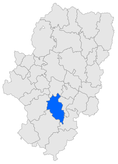
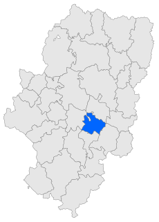
Montalbán is a town and municipality in Spain with a population of 1,538, an area of 82 km² and a density of 18.75, located in Teruel province, in the autonomous community of Aragón. It is the historical and cultural capital of the Cuencas Mineras Aragonese comarca.

Castel de Cabra municipality in Aragon, Spain

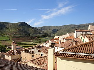
Castel de Cabra is a municipality in Cuencas Mineras, province of Teruel, Aragon, Spain. According to the 2010 census the municipality has a population of 140 inhabitants. Its postal code is 44706.

Villanueva del Rebollar de la Sierra municipality in Aragon, Spain

Villanueva del Rebollar de la Sierra is a municipality located in the province of Teruel, Aragon, Spain. According to the 2004 census (INE), the municipality has a population of 51 inhabitants.

Sistema Ibérico mountain range

The Iberian System, is one of the major systems of mountain ranges in Spain. It consists of a vast and complex area of mostly relatively high and rugged mountain chains and massifs located in the central region of the Iberian Peninsula, but reaching almost the Mediterranean coast in the Valencian Country in the east.

Maestrazgo, Aragon Comarca in Aragon, Spain

Maestrazgo is a comarca in southeastern Aragon, Spain. Its names derives from the Maestrat/Maestrazgo mountain massif that extends to the east to the Comarques of the Valencian Community Alt Maestrat and Baix Maestrat. The most important town is Cantavieja. It is bordered by the Aragonese comarcas of Andorra-Sierra de Arcos, Cuencas Mineras, Comunidad de Teruel and Bajo Aragón, in the north and in the west and Gúdar-Javalambre in the south, as well as with the Castellón Province in the east. Some municipal terms of this comarca are part of the historical region of Lower Aragon.

Moncayo Massif mountain massif in Spain

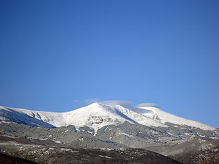
Moncayo is a 15 km long and about 7 km wide mountain massif giving name to the Tarazona y el Moncayo comarca, Aragon, Spain. The Moncayo's highest summit, San Miguel (2,314 m), is the highest point in the 500 km long Sistema Ibérico.

Bajo Martín Comarca in Aragon, Spain

Bajo Martín is a comarca in Aragon. It is part of the historical region of Lower Aragon. It is located in Teruel Province, in the transitional area between the Iberian System and the Ebro Valley.

Lower Aragon Natural region in Spain

Lower Aragon, also known as Tierra Baja, is a natural and historical region in Aragon, Spain. The name "Lower Aragon" refers to the areas of the lowest altitude within the Ebro river basin, but the historical region encompasses only the river basins of several right tributaries of the Ebro River, namely the Matarranya, Guadalope, Regallo, Martín and Aguas, located between the Ebro and the Iberian mountain range.

Andorra-Sierra de Arcos Comarca in Aragon, Spain

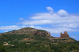
Andorra-Sierra de Arcos is a comarca in Aragon, Spain. It is located in Teruel Province and it is named after Sierra de Arcos, a range of this mountainous area of the Sistema Ibérico. The capital is Andorra, with 8,156 inhabitants the largest town of the comarca.

Montes Universales

Montes Universales is a 32 km (20 mi) long mountain range in the southeastern end of the Iberian System. Its highest point is the 1,935 m high summit known as Caimodorro. The 1,830 m high Muela de San Juan is another important peak.

Mountains of Sis mountain in Spain

The Mountains of Sis is a 28 km (17 mi) long mountain range of the Pre-Pyrenees. They are located between the valleys of rivers Isábena and the Escales Reservoir, Noguera Ribagorzana, in the Ribagorza comarca, Aragon, Spain. The ridge's highest summits are Pico de l´Amorriador (1791 m) and Puialto (1782 m). Other important summits are 1765 m high La Creu de Bonansa, 1490 m high Altaió d'Aulet and 1066 m high Tossal de Cornudella.

Sierra de Gúdar mountain in Spain

Sierra de Gúdar is a mountain range in the Gúdar-Javalambre and Maestrazgo comarcas of Aragon and the Alto Mijares comarca of the Valencian Community, Spain. The highest point in the range is Peñarroya (2,019 m).

Sierra de Cucalón mountain in Spain

Sierra de Cucalón is a 25-kilometre (16 mi) long system of mountain ranges in Aragon, Spain, located between the comarcas of Jiloca and Cuencas Mineras.

Sierra Carrascosa

Sierra Carrascosa is a mountain range in the Maestrazgo comarca of Aragon, Teruel Province, Spain. The highest point in the range is Muela Carrascosa (1,214 m). The Guadalope River flows along the NW side of the range.

Sierra de Caballos

Sierra de Caballos or Sierra de los Caballos is a mountain range in the Maestrazgo and Bajo Aragón comarcas of Aragon, Teruel Province, Spain. The highest point in the range is Las Artigas (1,205 m). The Guadalopillo River flows along the northern side of the range.

Sierra Menera mountain in Spain

Sierra Menera is a 31 km (19 mi) long mountain range in the southwestern end of the Iberian System.

References

  1. Gran Enciclopedia Aragonesa - Sierra de San Just
  2. Angel Luis Cortés Gracia, Adolfo Maestro González, Los deslizamientos de la sierra de San Just, Instituto de Estudios Turolenses, 1998
  3. Gran Enciclopedia Aragonesa - Zancado, altos del
  4. Cañada Vellida - Sierra de Sant Just