
Awendaw is a small fishing town in Charleston County, South Carolina, United States. The population was 1,294 at the 2010 census. Awendaw is part of the Charleston, South Carolina metropolitan area.
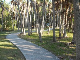
Fig Island, also known as 38CH42, is an archaeological site on the Atlantic Coast of South Carolina, consisting of three shell rings. Shell rings are curved shell middens wholly or partially surrounding a clear central area or plaza. The site includes one of the largest and most complex shell rings in North America, and one of the best preserved circular shell rings.
Indian Mound Park, also known as Shell Mound Park or Indian Shell Mound Park, is a park and bird refuge located on the northern shore of Dauphin Island, a barrier island of Mobile County, Alabama in the United States. In addition to the many birds which visit, a wide variety of botanical species contribute to the natural offerings. The site is historically significant due to the presence of prehistoric Indian shell middens, mounds composed of discarded oyster shells. The park was added to the National Register of Historic Places on August 14, 1973. It is administered by the Alabama Department of Conservation and Natural Resources.

Crystal River State Archaeological Site is a 61-acre (250,000 m2) Florida State Park located on the Crystal River and within the Crystal River Preserve State Park. The park is located two miles (3 km) northwest of the city of Crystal River, on Museum Point off U.S. 19/98.

Horr's Island is a significant Archaic period archaeological site located on an island in Southwest Florida formerly known as Horr's Island. Horr's Island is on the south side of Marco Island in Collier County, Florida. The site includes four mounds and a shell ring. It has one of the oldest known mound burials in the eastern United States, dating to about 3400 radiocarbon years Before Present (BP). One of the mounds has been dated to as early as 6700 BP. It was the largest known community in the southeastern United States to have been permanently occupied during the Archaic period.
The Madira Bickel Mound State Archaeological Site is an archaeological site on Terra Ceia Island in northwestern Palmetto, Florida, United States. It is located on Bayshore Drive, west of U.S. 19, a mile south of I-275. On August 12, 1970, it was added to the U.S. National Register of Historic Places. It is also a Florida State Park.
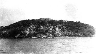
Mound Key Archaeological State Park is a Florida State Park, located in Estero Bay, near the mouth of the Estero River. One hundred and thirteen of the island's one hundred and twenty-five acres are managed by the park system. It is a complex of mounds and accumulated shell, fish bone, and pottery middens that rises more than 30 feet above the waters of the bay.
Turtle Mound is a prehistoric archaeological site located 9 miles (14 km) south of New Smyrna Beach, Florida, on State Road A1A. On September 29, 1970, it was added to the U.S. National Register of Historic Places. It is the largest shell midden on the mainland United States, with an approximate height of 50 feet (15 m). The mound extends for over 600 feet (180 m) along the Indian River shoreline and contains over 35,000 cubic yards (27,000 m3) of shells. Turtle Mound was estimated to be 75 feet (23 m) high before it was reduced by shellrock mining in the 19th and 20th centuries. Because it is visible seven miles out at sea, early Spanish explorers and subsequent mariners used the large mound as a landmark for coastal navigation. Today, the site is owned and managed by the National Park Service as part of Canaveral National Seashore.

Shell rings are archaeological sites with curved shell middens completely or partially surrounding a clear space. The rings were sited next to estuaries that supported large populations of shellfish, usually oysters. Shell rings have been reported in several countries, including Colombia, Peru, Japan, and the southeastern United States. Archaeologists continue to debate the origins and use of shell rings.
Sea Pines is a historic archeological site located at Sea Pines Resort, Hilton Head Island, Beaufort County, South Carolina. The site is one of 20 or more prehistoric Indian shell middens in a ring shape located from the central coast of South Carolina to the central coast of Georgia. It is believed to date early in the second millennium BC, and to contain some of the earliest pottery known in North America. The Sea Pines ring stands about two feet above a flat central area, which is about five feet above mean sea level.
Skull Creek is a historic archeological site located at Hilton Head Island, Beaufort County, South Carolina. The site includes two of 20 or more prehistoric Indian shell middens in a ring shape located from the central coast of South Carolina to the central coast of Georgia. It probably dates from early in the second millennium BC, and is likely to contain some of the earliest pottery known in North America. The Skull Creek rings are the only known example of a later ring superimposed over an earlier one.
Green's Shell Enclosure is a historic archeological site located at Hilton Head Island, Beaufort County, South Carolina. The site includes one of 20 or more prehistoric Indian shell middens in a ring shape located from the central coast of South Carolina to the central coast of Georgia. They are believed to date early in the second millennium BC, and they contain some of the earliest pottery known in North America.
Blair Mound is a historic archaeological site located near Winnsboro, Fairfield County, South Carolina. Blair Mound is an earthen mound structure in the form of a low, oval hummock. It measures approximately 75 by 50 yards and is just over 5 feet (1.5 m) high, with evidence of leveling for agricultural development.
Minim Island Shell Midden (38GE46) is a historic midden and archaeological site located near Georgetown, Georgetown County, South Carolina. The site consists of prehistoric midden deposits of shellfish remains, floral and faunal remains, and interred human burials. Cultural materials in the form of ceramics and lithics occur throughout the midden. These deposits are concentrated for a distance of about 100 feet along the shoreline of the Intracoastal Waterway.
Auld Mound (38CH41), also known as Yough Hall Plantation Shell Ring, is a historic mound located near Mount Pleasant, Charleston County, South Carolina. It is one of 20 or more prehistoric shell rings located from the central coast of South Carolina to the central coast of Georgia. On average, it measures 174 feet in diameter and stands 2 to 3 feet high. The midden is largely composed of oyster shell.
Buzzard's Island Site is a historic mound located near Mount Pleasant, Charleston County, South Carolina. It is one of 20 or more prehistoric shell rings located from the central coast of South Carolina to the central coast of Georgia. On average, it measures 178 feet in diameter and stands 3 feet high. The midden is largely composed of oyster shell.
Hanckel Mound (38CH7) is a historic mound located near Rockville, Charleston County, South Carolina. It is one of 20 or more prehistoric shell rings located from the central coast of South Carolina to the central coast of Georgia. On average, it measures 158 feet in diameter and stands 8 feet high. The midden is largely composed of oyster shell.
Horse Island (38CH14) is a historic mound located near Rockville, Charleston County, South Carolina. It is one of 20 or more prehistoric shell rings located from the central coast of South Carolina to the central coast of Georgia. On average, it measures 156 feet in diameter and stands 4 feet high. The midden is largely composed of oyster shell.
Lighthouse Point Shell Ring (38CH12), also known as Parrot's Point Shell Ring, is a historic mound located on James Island, Charleston County, South Carolina. It is one of 20 or more prehistoric shell rings located from the central coast of South Carolina to the central coast of Georgia. The midden contains a diverse array of biota.


