Shahrud, Iran

Last updated

Shahrud
Persian: شاهرود
City
Abr Jungle in Iran by Pouria Afkhami pixoos 05.jpg
Bayazid Bastami 7.jpg
`mrt myr `Zm shhrwd 03.jpg
Kashaneh Tower 5.jpg
bzr trykhy shhrwd (4).jpg
Miandasht Caravanserai2023-07-31 29.jpg
khrwnsry dh ml.jpg
armgh shykh bwlHsn khrqny 3.jpg
Iran location map.svg
Red pog.svg
Shahrud
Coordinates: 36°24′48″N54°58′41″E / 36.41333°N 54.97806°E / 36.41333; 54.97806 [1]
Country Iran
Province Semnan province
County Shahrud
District Central
Government
  MayorMohsen Ahmadi
Elevation
1,345 m (4,413 ft)
Population
 (2016) [2]
   Urban
150,129
Time zone UTC+3:30 (IRST)
Area code +9823
Website shahrood.ostan-sm.ir

Shahrud [3] (Persian : شاهرود, also Romanized as Shâhrūd, Shahrood, and Shahroud; also known as Shârūd) is a city in the Central District of Shahrud County, Semnan province, Iran, serving as capital of both the county and the district. [4]

Contents

As of 1991, Shahrud had a population of 92,195. [5] At the 2006 census, its population was 126,916 in 35,548 households. [6] The following census in 2011 counted 140,474 people in 40,931 households. [7] The latest census in 2016 showed a population of 150,129 people in 47,606 households. [2]

Situated about an altitude of 1345 m, it is located at latitude 36°25'N, longitude 055°01'E. The main launch site of the Iranian Space Agency is near Shahrood. It is also well known for unique types of grapes which are cultivated specially in Shahrud. Consequently, Shahrood is known as the City of Grapes.

Although absent from earlier historical sources, Shahrud has become an important town since the 19th century because of its location on the road from Tehran east to Khorasan. [5] It now also is on the railway. [5] A road runs from Shahrud across the Alborz mountains to the Caspian coastal plains in the north; it is accessible throughout winter. [5] Shahrud was renamed Imāmrūd after the Iranian Revolution of 1979, but has since reverted to the old name. [5] It is located just south of the historical city of Bastam. [5]

Geography

Some 410 kilometers to the east of Tehran, halfway between the capital and Mashad, and at the junction with the Gorgan road, sits the modern city of Shahrud, which has grown to absorb the historic town of Bastam situated in the hills a few kilometers to the north.

From the north, it is surrounded by the Alborz mountains, and from the south by the arid salty deserts. The river of Tash, after crossing this town, reaches the south deserts. The weather on the mountainous areas is cold and it is somewhat temperate in other parts of the city.

Shahrud is located in the Damghan basin, a sub-basin of the Kavir basin which also contains the Great Salt Desert.

Climate

Shahrud has a cold desert climate (Köppen climate classification BWk) with hot summers and very cold winters with freezing nights. Precipitation is very low, and mostly falls in winter (often as snow) and spring.

Climate data for Shahrud, Iran (1991–2020 normals, extremes 1961–2020)
MonthJanFebMarAprMayJunJulAugSepOctNovDecYear
Record high °C (°F)19.0
(66.2)
22.6
(72.7)
29.6
(85.3)
32.4
(90.3)
37.4
(99.3)
39.4
(102.9)
42.0
(107.6)
42.0
(107.6)
37.0
(98.6)
32.2
(90.0)
29.0
(84.2)
19.4
(66.9)
42.0
(107.6)
Mean daily maximum °C (°F)6.6
(43.9)
9.3
(48.7)
15.0
(59.0)
21.4
(70.5)
26.8
(80.2)
31.6
(88.9)
33.7
(92.7)
32.8
(91.0)
29.2
(84.6)
22.7
(72.9)
14.2
(57.6)
8.2
(46.8)
21.0
(69.8)
Daily mean °C (°F)1.8
(35.2)
4.0
(39.2)
9.1
(48.4)
15.2
(59.4)
20.3
(68.5)
25.0
(77.0)
27.3
(81.1)
26.2
(79.2)
22.2
(72.0)
16.0
(60.8)
8.6
(47.5)
3.4
(38.1)
14.9
(58.8)
Mean daily minimum °C (°F)−1.8
(28.8)
−0.2
(31.6)
4.2
(39.6)
9.7
(49.5)
14.5
(58.1)
19.0
(66.2)
21.7
(71.1)
20.4
(68.7)
16.4
(61.5)
10.7
(51.3)
4.3
(39.7)
−0.2
(31.6)
9.9
(49.8)
Record low °C (°F)−14.0
(6.8)
−14.0
(6.8)
−8.8
(16.2)
−7.0
(19.4)
−1.0
(30.2)
6.0
(42.8)
10.0
(50.0)
8.0
(46.4)
2.0
(35.6)
−3.0
(26.6)
−14.2
(6.4)
−11.0
(12.2)
−14.2
(6.4)
Average precipitation mm (inches)14.8
(0.58)
21.1
(0.83)
29.5
(1.16)
27.6
(1.09)
16.4
(0.65)
5.5
(0.22)
2.6
(0.10)
1.3
(0.05)
5.5
(0.22)
7.5
(0.30)
10.9
(0.43)
13.7
(0.54)
156.4
(6.16)
Average precipitation days (≥ 1.0 mm)2.73.44.14.53.31.60.60.41.01.52.12.527.7
Average relative humidity (%)62.055.047.042.038.033.034.035.038.044.054.063.045.4
Average dew point °C (°F)−5.2
(22.6)
−5.0
(23.0)
−2.8
(27.0)
1.0
(33.8)
4.5
(40.1)
6.6
(43.9)
9.2
(48.6)
8.4
(47.1)
6.1
(43.0)
2.7
(36.9)
−1.1
(30.0)
−3.4
(25.9)
1.8
(35.2)
Mean monthly sunshine hours 184.0187.0218.0239.0282.0327.0339.0342.0302.0263.0199.0170.03,052
Source: NOAA [8] [9]

History

In 2006, traces of a prehistoric, 8000-year-old settlements were found in Shahrud. This is the pre-historical site of Deh Kheyr, Semnan, located in Shahrud Plain, 15 kilometers from the city of Shahrud. The discoveries included ovens, craft workshops, and other evidence of settlements.

Archeological excavations in different parts of Shahrud Plain indicate the existence of villages in this area during 7-5 millennium BC. [10]

As a modern city, the city of Shahrud was merely a village before the reign of Fath Ali Shah of the Qajar dynasty, with two old castles and a small farm named "Shabdary". The surrounding areas however, such as Biarjomand, Miami and Bastam do have a distant history.

The old town of Bastam is located 6 km north of Shahrood. Its pre-Islamic history is not clear, but according to some historians, it was built during Shapur II period (310-379 CE). During the Abbasid era, it was the second largest town (following Damghan) in the Qomis province.

The town was visited by Nasser Khosrow Qubadiani, the Iranian poet of the 12th century, and mentioned by him as the center of the Qomis province. Bastam declined during the Mongol era assaults, and Shahrud eventually took its place.

Attractions

Shahrud's geographical characteristics are varied, with cloud forests in the north and from the south it meets the central desert of Iran. The most interesting geographical and historical attractions of Shahrud are as follows:

Notable people

Higher education

Related Research Articles

<span class="mw-page-title-main">Semnan province</span> Province of Iran

Semnan province is one of the 31 provinces of Iran. It is in the north of the country, with its center and capital in the city of Semnan. The province of Semnan covers an area of 96,816 square kilometers and stretches along the Alborz mountain range, bordering on Kavir desert in its southern parts.

<span class="mw-page-title-main">Semnan, Iran</span> City in Semnan province, Iran

Semnan is a city in the Central District of Semnan County, Semnan province, Iran, serving as capital of the province, the county and the district. The city is on the alluvial fan of the Golrudbar creek in the north-central part of the country, 216 km east of Tehran and 640 km west of Mashhad. With a population of 185,129 people in 2016, Semnan is the most populous city in the province and the hub of the Semnani language, a sub-branch of the Iranian languages spoken to the north. It is home to the Semnani ethnic group.

<span class="mw-page-title-main">Damghan</span> City in Semnan province, Iran

Damghan is a city in the Central District of Damghan County, Semnan province, Iran, serving as capital of both the county and the district.

<span class="mw-page-title-main">Bastam</span> City in Semnan province, Iran

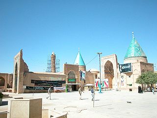
Bastam is a city in, and the capital of, Bastam District of Shahrud County, Semnan province, Iran.

<span class="mw-page-title-main">Mehdishahr</span> City in Semnan province, Iran

Mehdishahr (Persian: مهدی‌شهر, also Romanized as Mehdīshahr; formerly, Sang-e Sar is a city in the Central District of Mehdishahr County, Semnan province, Iran, serving a capital of both the county and the district.

<span class="mw-page-title-main">Abu al-Hassan al-Kharaqani</span> Iranian Sufi (963–1033)

Abu 'l-Hassan Ali ibn Ahmad ibn Salmān al-Kharaqāni was one of the master Sufis of Islam. He was born in 963 of Persian parents in Khorasan in the village of Qaleh Now-e Kharaqan and died on the day of Ashura in 1033.

<span class="mw-page-title-main">Shahrud County</span> County in Semnan province, Iran

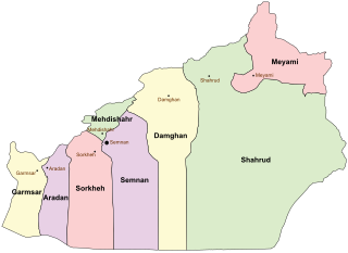
Shahrud County is in Semnan province, Iran. Its capital is the city of Shahrud.

Dibaj is a city in the Central District of Damghan County, Semnan province, Iran. It was the administrative center for Rudbar Rural District before being transferred to the city of Kalateh Rudbar.

<span class="mw-page-title-main">Shahrud (river)</span>

The Shahrood or Shah-Rud, also translated as Shah River, is a river of northern Iran.

<span class="mw-page-title-main">856 Damghan earthquake</span> Earthquake in Iran

The 856 Damghan earthquake or the 856 Qumis earthquake occurred on 22 December 856. The earthquake had an estimated magnitude of 7.9, and a maximum intensity of X (Extreme) on the Mercalli intensity scale. The meizoseismal area extended for about 350 kilometres (220 mi) along the southern edge of the eastern Alborz mountains of present-day Iran including parts of Tabaristan and Gorgan. The earthquake's epicenter is estimated to be close to the city of Damghan, which was then the capital of the Persian province of Qumis. It caused approximately 200,000 deaths and is listed by the USGS as the sixth deadliest earthquake in recorded history. This death toll has been debated.

Beyarjomand is a city in, and the capital of, Beyarjomand District of Shahrud County, Semnan province, Iran. It was the capital of Beyarjomand Rural District before its capital was transferred to the village of Khan Khvodi.

Kalateh-ye Khij is a city in Bastam District of Shahrud County, Semnan province, Iran. It was the administrative center for Kalat-e Hay-ye Gharbi Rural District until transferred to the village of Khij.

Mojen is a city in Bastam District of Shahrud County, Semnan province, Iran.

Bastam District is in Shahrud County, Semnan province, Iran. Its capital is the city of Bastam.

Kharqan Rural District, formerly Bastam Rural District, is in Bastam District of Shahrud County, Semnan province, Iran. Its capital is the village of Qaleh Now-e Kharaqan.

Kalat-e Hay-ye Gharbi Rural District is in Bastam District of Shahrud County, Semnan province, Iran. Its capital is the village of Khij, transferred from the city of Kalateh-ye Khij.

Deh Kheyr is a village in Kharqan Rural District, Bastam District, Shahrud County, Semnan Province, Iran. At the 2006 census, its population was 182, in 39 families.

Kolamu is a village in Kharqan Rural District, Bastam District, Shahrud County, Semnan Province, Iran. At the 2006 census, its population was 737, in 197 families.

Miqan is a village in Kharqan Rural District of Bastam District, Shahrud County, Semnan province, Iran.

Qaleh Now-e Kharaqan is a village in, and the capital of, Kharqan Rural District of Bastam District, Shahrud County, Semnan province, Iran.

References

  1. OpenStreetMap contributors (25 April 2023). "Shahrud, Shahrud County" (Map). OpenStreetMap . Retrieved 25 April 2023.
  2. 1 2 "Census of the Islamic Republic of Iran, 1395 (2016)". AMAR (in Persian). The Statistical Center of Iran. p. 20. Archived from the original (Excel) on 17 November 2020. Retrieved 19 December 2022.
  3. Shahrud, Iran can be found at GEOnet Names Server , at this link , by opening the Advanced Search box, entering "-3062042" in the "Unique Feature Id" form, and clicking on "Search Database".
  4. Habibi, Hassan (21 June 1369). "Approval of the organization and chain of citizenship of the elements and units of the national divisions of Semnan province, centered in Semnan city". Lamtakam (in Persian). Ministry of Interior, Defense Political Commission of the Government Council. Archived from the original on 2 January 2024. Retrieved 2 January 2024.
  5. 1 2 3 4 5 6 Bosworth, C.E. (1997). "SHĀH RŪD". In Bosworth, C.E.; van Donzel, E.; Heinrichs, W.P.; Lecomte, G. (eds.). The Encyclopaedia of Islam, Vol. IX (SAN-SZE) (PDF). Leiden: Brill. p. 198. ISBN   90-04-10422-4 . Retrieved 18 March 2022.
  6. "Census of the Islamic Republic of Iran, 1385 (2006)". AMAR (in Persian). The Statistical Center of Iran. p. 20. Archived from the original (Excel) on 20 September 2011. Retrieved 25 September 2022.
  7. "Census of the Islamic Republic of Iran, 1390 (2011)". Syracuse University (in Persian). The Statistical Center of Iran. p. 20. Archived from the original (Excel) on 20 January 2023. Retrieved 19 December 2022.
  8. "World Meteorological Organization Climate Normals for 1991-2020 — Shahrud, Iran". National Oceanic and Atmospheric Administration. Retrieved 1 January 2024.
  9. "Shahrood Climate Normals 1961–1990". National Oceanic and Atmospheric Administration . Retrieved 28 December 2012.
  10. Traces of Prehistoric Civilization Discovered in Shahrud (2006)