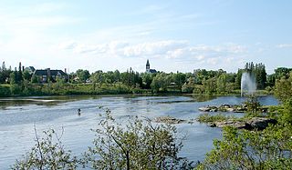
Shebandowan River

Last updated
Shebandowan River
Shebandowan - panoramio.jpg
Canada Ontario relief location map.jpg
Red pog.svg
Location of the mouth of the Shebandowan River in Ontario
Location
Country Canada
Province Ontario
Region Northeastern Ontario
District Thunder Bay
Physical characteristics
Source Lower Shebandowan Lake
  locationConacher Township
  coordinates 48°37′11″N90°03′45″W / 48.61972°N 90.06250°W / 48.61972; -90.06250
  elevation449 m (1,473 ft)
Mouth Matawin River
  location
Horne Township
  coordinates
48°32′56″N89°53′27″W / 48.54889°N 89.89083°W / 48.54889; -89.89083 Coordinates: 48°32′56″N89°53′27″W / 48.54889°N 89.89083°W / 48.54889; -89.89083
  elevation
366 m (1,201 ft)
Basin features
River system Great Lakes Basin
Tributaries 
  left Oskondaga River

The Shebandowan River is a river in Thunder Bay District in Northwestern Ontario, Canada. [1] It is in the Great Lakes Basin and is a left tributary of the Matawin River. Three-quarters of the length of the river valley is paralleled by Ontario Highway 11, at this point part of the Trans-Canada Highway; and the entire length of the river valley is paralleled by a Canadian National Railway main line, built originally as the Canadian Northern Railway transcontinental main line.

River Natural flowing watercourse

A river is a natural flowing watercourse, usually freshwater, flowing towards an ocean, sea, lake or another river. In some cases a river flows into the ground and becomes dry at the end of its course without reaching another body of water. Small rivers can be referred to using names such as stream, creek, brook, rivulet, and rill. There are no official definitions for the generic term river as applied to geographic features, although in some countries or communities a stream is defined by its size. Many names for small rivers are specific to geographic location; examples are "run" in some parts of the United States, "burn" in Scotland and northeast England, and "beck" in northern England. Sometimes a river is defined as being larger than a creek, but not always: the language is vague.

Thunder Bay District District in Ontario, Canada

Thunder Bay District is a district and census division in Northwestern Ontario in the Canadian province of Ontario. The district seat is Thunder Bay.

Northwestern Ontario Secondary region in Ontario, Canada

Northwestern Ontario is a secondary region of Northern Ontario which lies north and west of Lake Superior, and west of Hudson Bay and James Bay. It includes most of subarctic Ontario. Its western boundary is the Canadian province of Manitoba, which disputed Ontario's claim to the western part of the region. Ontario's right to Northwestern Ontario was determined by the Judicial Committee of the Privy Council in 1884 and confirmed by the Canada Act, 1889 of the Parliament of the United Kingdom. In 1912, the Parliament of Canada by the Ontario Boundaries Extension Act gave jurisdiction over the District of Patricia to Ontario, thereby extending the northern boundary of the province to Hudson Bay.

Contents

Course

The river begins at Lower Shebandowan Lake, [2] part of a trio of lakes (Upper, Middle and Lower Shebandown lakes) known collectively as Shebandowan Lakes, [3] in geographic Conacher Township. [4] It exits the lake east over a dam at the community of Shebandowan, [5] passes into geographic Blackwell Township, [6] continues east into geographic Dawson Road Lots Township, [7] and takes in the left tributary Oskondaga River south of the community of Shabaqua Corners. [8] The river leaves Ontario Highway 11 and turns southeast into geographic Laurie Township, [9] passes the community of Shabaqua, [10] enters geographic Horne Township, [11] and reaches its mouth at the Matawin River. The Matawin River flows via the Kaministiquia River to Lake Superior.

Shebandowan Lakes group of lakes in Canada

Shebandowan Lakes is the name for the combined entity of three lakes — Upper Shebandowan Lake at the west, Middle Shebandowan Lake at the centre, and Lower Shebandowan Lake at the east — in the Unorganized Part of Thunder Bay District in Northwestern Ontario, Canada. The lakes are in the Great Lakes Basin, and Lower Shebandowan Lake is the source of the Shebandowan River.

Oskondaga River watercourse in Canada

The Oskondaga River is a river in Thunder Bay District in Northwestern Ontario, Canada. It is in the Great Lakes Basin and is a left tributary of the Shebandowan River. The river valley is paralleled by Ontario Highway 17, at this point part of the Trans-Canada Highway; and by both the Canadian Pacific Railway transcontinental main line, still in operation, and the Canadian National Railway Graham Subdivision main line, originally built as part of the National Transcontinental Railway, now abandoned.

Shabaqua Corners dispersed rural communityunincorporated area in Ontario, Canada

Shabaqua Corners is a dispersed rural community and unincorporated area in geographic Dawson Road Lots Township in the Unorganized Part of Thunder Bay District in Northwestern Ontario, Canada. It is 56 kilometres (35 mi) west of Thunder Bay at the junction of Ontario Highway 17 and Ontario Highway 11; both highways at this point are part of the Trans-Canada Highway. There is an Ontario Provincial Police detachment in the community. The Oskondaga River flows through the community to its mouth at the Shebandowan River just to the south.

Tributaries

See also

Related Research Articles

Kapuskasing River river in Northeastern Ontario, Canada

The Kapuskasing River is a river in the James Bay drainage basin in Cochrane District and Algoma District in northeastern Ontario, Canada. The river is a left tributary of the Mattagami River.

Bobs Lake (Tay River)

Bobs Lake is a lake in Frontenac County and Lanark County in Eastern Ontario, Canada. It is in the St. Lawrence River drainage basin and is the source of the Tay River.

Carhess Creek river in Canada

Carhess Creek is a river in Greater Sudbury and Sudbury District in Northeastern Ontario, Canada. It is in the Great Lakes Basin and is a right tributary of the Onaping River. The name is a portmanteau of the names of two geographic townships through which it flows, Hess Township and Cartier Township.

Onaping River watercourse in Canada

The Onaping River is a river in Greater Sudbury and Sudbury District in Northeastern Ontario, Canada. It is in the Great Lakes Basin and is a right tributary of the Vermilion River.

Michaud River watercourse in Canada

The Michaud River is a river in Sudbury District in Northeastern Ontario, Canada. It is in the Great Lakes Basin and is a left tributary of the Onaping River.

Matawin River (Ontario)

The Matawin River is a river in Thunder Bay District in Northwestern Ontario, Canada. It is in the Great Lakes Basin and is a right tributary of the Kaministiquia River.

Wiegand River watercourse in Canada

The Wiegand River is a river in Thunder Bay District in Northwestern Ontario, Canada. It is in the Great Lakes Basin and is a right tributary of the Matawin River.

Swamp River (Ontario) river in Canada

The Swamp River is a river in Thunder Bay District in Northwestern Ontario, Canada. It is in the Great Lakes Basin and is a tributary of Shebandowan Lakes.

Kashabowie River watercourse in Canada

The Kashabowie River is a river in southwestern Thunder Bay District in Northwestern Ontario, Canada. It is in the Great Lakes Basin and is a tributary of the Shebandowan Lakes.

Dunrankin River river in Northeastern Ontario, Canada

The Dunrankin River is a river in Algoma District and Sudbury District in northeastern Ontario, Canada. It is in the James Bay drainage basin, begins at Upper Dunrankin Lake and is a left tributary of the Kapuskasing River.

Swanson River (Ontario) watercourse in Canada

The Swanson River is a river in Sudbury District in northeastern Ontario, Canada. It is in the James Bay drainage basin, begins south of Mageau Lake and is a left tributary of the Chapleau River.

Borden River (Ontario) watercourse in Ontario, Canada

The Borden River is a river in Sudbury District in northeastern Ontario, Canada. It is in the James Bay drainage basin, and is a left tributary of the Nemegosenda River.

South Greenhill River watercourse in Canada

The South Greenhill River is a river in Algoma District and Sudbury District in northeastern Ontario, Canada. It is in the James Bay drainage basin, and is a right tributary of the Greenhill River.

Fire River (Ontario) watercourse in Canada

The Fire River is a river in Algoma District in northeastern Ontario, Canada. It is in the James Bay drainage basin, and is a left tributary of the Missinaibi River.

Little Fire River watercourse in Canada

The Little Fire River is a river in geographic Moorehouse Township, Algoma District in northeastern Ontario, Canada. It is in the James Bay drainage basin, and is a tributary of the Fire River.

Jocko River (Ontario) watercourse in Canada

The Jocko River is a river in Nipissing District in Northeastern Ontario, Canada. It is in the Saint Lawrence River drainage basin, is a right tributary of the Ottawa River, and lies entirely within Jocko Rivers Provincial Park.

Grindstone Creek (Algoma District) stream in Canada

Grindstone Creek is a stream in the Unorganized North Part of Algoma District in Northeastern Ontario, Canada. It is in the Great Lakes Basin and is a left tributary of the Mississagi River.

References

  1. "Shebandowan River". Geographical Names Data Base. Natural Resources Canada . Retrieved 2014-09-01.
  2. "Lower Shebandowan Lake". Geographical Names Data Base. Natural Resources Canada . Retrieved 2014-09-01.
  3. "Shebandowan Lakes". Geographical Names Data Base. Natural Resources Canada . Retrieved 2014-09-01.
  4. "Conacher" (PDF). Geology Ontario - Historic Claim Maps. Ontario Ministry of Northern Development, Mines and Forestry . Retrieved 2014-09-01.
  5. "Shebandowan". Geographical Names Data Base. Natural Resources Canada . Retrieved 2014-09-01.
  6. "Blackwell" (PDF). Geology Ontario - Historic Claim Maps. Ontario Ministry of Northern Development, Mines and Forestry . Retrieved 2014-09-01.
  7. "Dawson Road" (PDF). Geology Ontario - Historic Claim Maps. Ontario Ministry of Northern Development, Mines and Forestry. Archived from the original (PDF) on 2014-09-03. Retrieved 2014-09-01.
  8. "Shabaqua Corners". Geographical Names Data Base. Natural Resources Canada . Retrieved 2014-09-01.
  9. "Laurie" (PDF). Geology Ontario - Historic Claim Maps. Ontario Ministry of Northern Development, Mines and Forestry . Retrieved 2014-09-01.
  10. "Shabaqua". Geographical Names Data Base. Natural Resources Canada . Retrieved 2014-09-01.
  11. "Horne" (PDF). Geology Ontario - Historic Claim Maps. Ontario Ministry of Northern Development, Mines and Forestry. Archived from the original (PDF) on 2014-09-03. Retrieved 2014-09-01.

Sources

Ministry of Transportation of Ontario government ministry in Ontario

The Ministry of Transportation of Ontario (MTO) is the provincial ministry of the Government of Ontario that is responsible for transport infrastructure and related law in Ontario. The ministry traces its roots back over a century to the 1890s, when the province began training Provincial Road Building Instructors. In 1916, the Department of Public Highways of Ontario (DPHO) was formed and tasked with establishing a network of provincial highways. The first was designated in 1918, and by the summer of 1925, sixteen highways were numbered. In the mid-1920s, a new Department of Northern Development (DND) was created to manage infrastructure improvements in northern Ontario; it merged with the Department of Highways of Ontario (DHO) on April 1, 1937. In 1971, the Department of Highways took on responsibility for Communications and in 1972 was reorganized as the Ministry of Transportation and Communications (MTC), which then became the Ministry of Transportation in 1987.

The Ministry of Municipal Affairs and Housing is the department of the Government of Ontario that is responsible for municipal affairs and housing in the Canadian province of Ontario.