Sheringham is a seaside town and civil parish in the county of Norfolk, England. The motto of the town, granted in 1953 to the Sheringham Urban District Council, is Mare Ditat Pinusque Decorat, Latin for "The sea enriches and the pine adorns".
Hoveton is a village and civil parish in the English county of Norfolk. It is located within the Norfolk Broads, and immediately across the River Bure from the village of Wroxham. Whilst Hoveton is north of the river, Wroxham is south; but many people refer to the whole settlement as "Wroxham".

Calke Abbey is a Grade I listed country house near Ticknall, Derbyshire, England, in the care of the charitable National Trust.

Blickling Hall is a Jacobean stately home situated in 5,000 acres of parkland in a loop of the River Bure, near the village of Blickling north of Aylsham in Norfolk, England. The mansion was built on the ruins of a Tudor building for Sir Henry Hobart from 1616 and designed by Robert Lyminge. The library at Blickling Hall contains one of the most historically significant collections of manuscripts and books in England, containing an estimated 13,000 to 14,000 volumes. The core collection was formed by Sir Richard Ellys. The property passed into the care of the National Trust in 1940.

Lancelot Brown, more commonly known as Capability Brown, was an English gardener and landscape architect, who remains the most famous figure in the history of the English landscape garden style. He is remembered as "the last of the great English 18th-century artists to be accorded his due" and "England's greatest gardener".

Humphry Repton was the last great designer of the classic phase of the English landscape garden, often regarded as the successor to Capability Brown. His style is thought of as the precursor of the more intricate and eclectic styles of the 19th century. His first name is often incorrectly spelt "Humphrey".

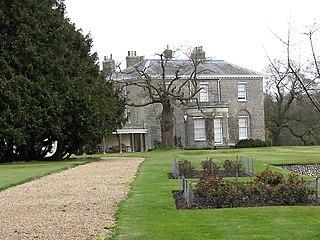
Wimpole Estate is a large estate containing Wimpole Hall, a country house located within the civil parish of Wimpole, Cambridgeshire, England, about 8+1⁄2 miles southwest of Cambridge. The house, begun in 1640, and its 3,000 acres (12 km2) of parkland and farmland are owned by the National Trust. The estate is regularly open to the public and received over 335,000 visitors in 2019. Wimpole is the largest house in Cambridgeshire.
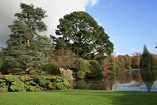
Sheffield Park and Garden is an informal landscape garden five miles east of Haywards Heath, in East Sussex, England. It was originally laid out in the 18th century by Capability Brown, and further developed as a woodland garden in the early 20th century by its then owner, Arthur Gilstrap Soames. It is now owned by the National Trust.

Beeston Regis is a village and civil parish in the North Norfolk district of Norfolk, England. It is about a mile (2 km) east of Sheringham, Norfolk and near the coast. The village is 2 miles (3 km) west of Cromer and 16 miles (26 km) north of the city of Norwich. According to the 2011 census, it had a population of 1,062. There is a frequent bus service on the coast road A149 and a rail service from the nearby stations of Sheringham to the west and West Runton to the east, where the Bittern Line runs a frequent service between Norwich, Cromer and Sheringham. The nearest airport is Norwich International Airport.
Stody is a village and a civil parish in the English county of Norfolk. The village is 13.2 miles (21.2 km) west south west of Cromer, 21.8 miles (35.1 km) north north west of Norwich and 125 miles (201 km) north north east of London. The village lies 4.1 miles (6.6 km) south west of the town of Holt. The nearest railway station is at Sheringham for the Bittern Line which runs between Sheringham, Cromer and Norwich. The nearest airport is Norwich International Airport.

The A149 is commonly known as "The Coast Road" to local residents and tourists, as this road runs along the North Norfolk coast from King's Lynn to Great Yarmouth, via coastal villages.

Matlaske is a village and a civil parish in the English county of Norfolk. The village is 21.6 miles (34.8 km) North-north-west of Norwich, 9.3 miles (15.0 km) south-west of Cromer and 136 miles (219 km) north-north-east of London. The nearest railway station is at Sheringham for the Bittern Line which runs between Sheringham, Cromer and Norwich. The nearest airport is Norwich International Airport. The parish of Matlask in the 2001 census, a population of 124, increasing to 139 at the 2011 Census. For the purposes of local government, the parish falls within the district of North Norfolk.

Wickmere is a village and a civil parish in the English county of Norfolk, 18.9 miles (30.4 km) north of Norwich, 7.3 miles (11.7 km) south-southwest of Cromer and 132 miles (212 km) northeast of London. The nearest railway station is at Gunton for the Bittern Line which runs between Sheringham, Cromer and Norwich. The nearest airport is Norwich International Airport. In the 2001 census it had a population of 125, which increased to 158 at the 2011 census. For the purposes of local government, the it falls within the district of North Norfolk.

Scarrow Beck is a minor watercourse which rises in the north of the English county of Norfolk. It is a tributary of the River Bure. Its spring is in the North Norfolk village of Aylmerton west of the main street. It eventually merges, after 7.7 miles (12.4 km) with the River Bure at Ingworth just north of the Blickling Hall estate. There are two watermills on the beck, both of which are no longer in working order. A third windmill at Gresham stands on Gur Beck, a small tributary of Scarrow Beck.

Sheringham Lifeboat Station is an RNLI operated lifeboat station located in the town of Sheringham in the English county of Norfolk. Since 1992, the station has been inshore operations only - currently with an Atlantic 85 rigid inflatable - offshore lifeboats are to the east at Cromer and the west at Wells-next-the-sea.

Catton Park is a Grade 2 listed public park located in the village of Old Catton some 2 miles (3.2 km) north of central Norwich. The park covers 70 acres (28 ha) and was landscape gardener Humphry Repton's first commission. Adjacent, but outside the boundary of the present today park are two open spaces; the War Memorial Deer Park at Spixworth Road and the Buttercup Meadow at the junction of Oak Lane and Spixworth Road. Both were historically part of Catton Park and together with Catton Hall form part of the Old Catton conservation area.

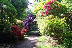
Sheringham Hall is a Grade II* listed building which stands in the grounds of its park. The house is close to the village of Upper Sheringham in the English County of Norfolk in the United Kingdom. The hall was built on the instructions of Abbot and Charlotte Upcher who engaged the architect and landscape designer Humphry Repton and his son John Adey Repton to build the house and to present designs for the surrounding parkland. Humphry worked on the landscape and John Adey designed the hall. National Trust members and guests have no rights of access across the park and farmland surrounding Sheringham Hall. Access is solely at the discretion of the owners of George Youngs (Farms) Ltd which farms the Sheringham estate. George Youngs (Farms) Ltd is owned by Paul Doyle and Gergely Battha-Pajor who also own the long leasehold of Sheringham Hall.

Honing Hall is a Grade II* listed building which stands in a small estate close to the village of Honing in the English county of Norfolk within the United Kingdom. It was built in 1748 for a wealthy Worstead weaver called Andrew Chamber.

Felbrigg Woods is a 164.6-hectare (407-acre) biological Site of Special Scientific Interest south-west of Cromer in Norfolk. It is the main part of the grounds of Felbrigg Hall, a National Trust property which is listed on the Register of Historic Parks and Gardens of Special Historic Interest in England. It is a Nature Conservation Review site, Grade 2, and it is in the Norfolk Coast Area of Outstanding Natural Beauty.