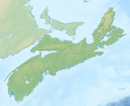
Nova Scotia is a province of Canada, located on its east coast. It is one of the three Maritime provinces and most populous province in Atlantic Canada, with an estimated population of over 1 million as of 2024; it is also the second-most densely populated province in Canada, and second-smallest province by area. The province comprises the Nova Scotia peninsula and Cape Breton Island, as well as 3,800 other coastal islands. The province is connected to the rest of Canada by the Isthmus of Chignecto, on which the province's land border with New Brunswick is located.

An algal bloom or algae bloom is a rapid increase or accumulation in the population of algae in fresh water or marine water systems. It is often recognized by the discoloration in the water from the algae's pigments. The term algae encompasses many types of aquatic photosynthetic organisms, both macroscopic multicellular organisms like seaweed and microscopic unicellular organisms like cyanobacteria. Algal bloom commonly refers to the rapid growth of microscopic unicellular algae, not macroscopic algae. An example of a macroscopic algal bloom is a kelp forest.

Dartmouth is a built-up community of Halifax Regional Municipality, Nova Scotia, Canada. Located on the eastern shore of Halifax Harbour, Dartmouth has 101,343 residents as of 2024.

Cape Breton Regional Municipality is the Canadian province of Nova Scotia's second largest municipality and the economic heart of Cape Breton Island. As of 2021 the municipality has a population of 93,694. The municipality was created in 1995 through the amalgamation of eight municipalities located in Cape Breton County.

Halifax is the capital and most populous municipality of the Canadian province of Nova Scotia, and the most populous municipality in Atlantic Canada. As of 2023, it is estimated that the population of the Halifax CMA was 518,711, with 348,634 people in its urban area. The regional municipality consists of four former municipalities that were amalgamated in 1996: Halifax, Dartmouth, Bedford, and Halifax County.
Enfield is an unincorporated community in the Canadian province of Nova Scotia. The community is located 5 kilometres (3.1 mi) north of Halifax Stanfield International Airport in the Shubenacadie Valley on the border of Hants and Halifax counties in Nova Scotia, Canada. Specifically, Enfield exists in both the East Hants Municipal District and Halifax and is divided by the Shubenacadie River.

Halifax Regional Council is the governing body of Halifax, known as the Halifax Regional Municipality (HRM). Halifax is governed by a mayor-council system, where councillors are elected from sixteen geographic districts though a first-past-the-post system and the mayor is elected via a municipality-wide first-past-the-post vote. Halifax Regional Council was formed in 1996 and consisted of twenty-three councillors and one mayor. It was reduced in size to sixteen councillors and the mayor in 2012. The council meets at Halifax City Hall.

East Hants, officially named the Municipality of the District of East Hants, is a district municipality in Hants County, Nova Scotia, Canada. Statistics Canada classifies the district municipality as a municipal district.

The Shubenacadie Canal is a canal in central Nova Scotia, Canada. It links Halifax Harbour with the Bay of Fundy by way of the Shubenacadie River and Shubenacadie Grand Lake. Begun in 1826, it was not completed until 1861 and was closed in 1871. Currently small craft use the river and lakes, but only one lock is operational. Three of the nine locks have been restored to preserve their unique fusion of British and North American construction techniques. More extensive restoration is planned.

Sullivan's Pond is an artificial lake and recreation area located in Dartmouth in Halifax Regional Municipality. It formed part of the Shubenacadie Canal.
Highway 102 is a north–south highway in the Canadian province of Nova Scotia that runs from Halifax to Onslow, immediately north of the town of Truro. It is the busiest highway in Atlantic Canada.
The Halifax Regional Municipality (HRM) in Nova Scotia, Canada has a widely varied geography.

The Shubenacadie River is a river in Nova Scotia, Canada. It has a meander length of approximately 72 km from its source at Shubenacadie Grand Lake to its mouth at the community of Maitland on the Cobequid Bay. The lower 30 km of the river is tidal and the river experiences a tidal bore twice daily, with some bores reaching up to 3 m in height at certain points along the river. Local tourism operators offer adventure seekers a chance to ride with the bore on high-horse power Zodiac Hurricanes. Tidal Bore Rafting was invented at the Tidal Bore Rafting Resort by H. Knoll. It is also a popular surfing spot for experienced sea kayakers.
Articles related to Nova Scotia include:
The Glooscap Trail is a scenic roadway in the Canadian province of Nova Scotia.

A harmful algal bloom (HAB), or excessive algae growth, is an algal bloom that causes negative impacts to other organisms by production of natural algae-produced toxins, water deoxygenation, mechanical damage to other organisms, or by other means. HABs are sometimes defined as only those algal blooms that produce toxins, and sometimes as any algal bloom that can result in severely lower oxygen levels in natural waters, killing organisms in marine or fresh waters. Blooms can last from a few days to many months. After the bloom dies, the microbes that decompose the dead algae use up more of the oxygen, generating a "dead zone" which can cause fish die-offs. When these zones cover a large area for an extended period of time, neither fish nor plants are able to survive. Harmful algal blooms in marine environments are often called "red tides".
Lake Charles is a small lake in Nova Scotia’s Halifax Regional Municipality between the communities of Dartmouth and Waverley. It is situated between Port Wallace in the south and Nova Scotia Highway 107 in the North, Nova Scotia Highway 118 in the west and Nova Scotia Route 318 to the east. It is the summit of the Shubenacadie Canal, where the level of the surface is 31 m above sea level. Located in the Shubenacadie watershed, it ultimately feeds into the Bay of Fundy. However, it also feeds into Halifax Harbour through the canal locks at Shubie Park.

The following outline is provided as an overview of and topical guide to Nova Scotia:

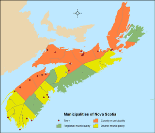
The Canadian province of Nova Scotia is divided into 49 municipalities, of which there are three types: regional (4), town (25), and county or district municipality (20).


