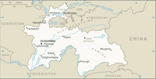
Tajikistan is nestled between Kyrgyzstan and Uzbekistan to the north and west, China to the east, and Afghanistan to the south. Mountains cover 93 percent of Tajikistan's surface area. The two principal ranges, the Pamir Mountains and the Alay Mountains, give rise to many glacier-fed streams and rivers, which have been used to irrigate farmlands since ancient times. Central Asia's other major mountain range, the Tian Shan, skirts northern Tajikistan. Mountainous terrain separates Tajikistan's two population centers, which are in the lowlands of the southern and northern sections of the country. Especially in areas of intensive agricultural and industrial activity, the Soviet Union's natural resource utilization policies left independent Tajikistan with a legacy of environmental problems.

The Syr DaryaSEER-DAR-yə, historically known as the Jaxartes, is a river in Central Asia. The name, which is Persian, literally means Syr Sea or Syr River. It originates in the Tian Shan Mountains in Kyrgyzstan and eastern Uzbekistan and flows for 2,256.25 kilometres (1,401.97 mi) west and north-west through Uzbekistan, Sughd province of Tajikistan, and southern Kazakhstan to the northern remnants of the Aral Sea. It is the northern and eastern of the two main rivers in the endorheic basin of the Aral Sea, the other being the Amu Darya.

The Uzbek Soviet Socialist Republic, also known as Soviet Uzbekistan, the Uzbek SSR, UzSSR, or simply Uzbekistan and rarely Uzbekia or Red Uzbekistan, was a union republic of the Soviet Union. It was governed by the Uzbek branch of the Soviet Communist Party, the legal political party, from 1925 until 1990. From 1990 to 1991, it was a sovereign part of the Soviet Union with its own legislation.

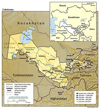
This article discusses the administrative-territorial division of the Republic of Uzbekistan. The Article 68 of the constitution of Uzbekistan defines:
The Republic of Uzbekistan shall consist of regions, districts, cities, towns, settlements, kishlaks and auls (villages) in Uzbekistan and the Republic of Karakalpakstan.
Jizzakh Region is one of the regions of Uzbekistan. It is located in the center/east of the country. It borders Tajikistan to the south and south-east, Samarqand Region to the west, Navoiy Region to the north-west, Kazakhstan to the north, and Sirdaryo Region to the east. It covers an area of 21,210 km2. The population is 1,443,408 with 53% living in rural areas.

Osh Region is a region of Kyrgyzstan. Its capital is Osh, which is not part of the region. It is bounded (clockwise) by Jalal-Abad Region, Naryn Region, China (Xinjiang), Tajikistan, Batken Region, and Uzbekistan. Its total area is 28,934 km2 (11,171 sq mi). The resident population of the region was 1,391,649 as of January 2021. The region has a sizeable Uzbek minority.
Namangan Region is one of the regions of Uzbekistan, located in the southern part of the Fergana Valley in far eastern part of the country. It is on the right bank of Syr Darya River and borders with Kyrgyzstan, Tajikistan, Tashkent Region, Fergana Region, and Andijan Region. It covers an area of 7,440 km2. The population is estimated to be 2,931,056 (2022), with 35% of the population living in rural areas. The great river Syrdarya, the main waterway in Central Asia, starts in the territory of Namangan. Syrdarya is formed from inflows of the rivers Naryn and Kara Darya. The Namangan region is very rich in various natural resources. In particular, the region extracts oil in Mingbulak District and big gold and diamond deposits have been discovered in Kosonsoy and Pop Districts. There are also large deposits of uranium, silver, aluminum, tungsten, iron, copper, granite, and marble, among others. There are two big mountain tunnels connecting the Fergana valley with the inner city area and other regions of the country, located in the territory of Namangan.

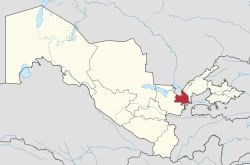
Tashkent Region is a viloyat (region) of Uzbekistan, located in the northeastern part of the country, between the Syr Darya River and the Tien Shan Mountains. It borders Kyrgyzstan, Tajikistan, Sirdaryo Region and Namangan Region, as well as the city of Tashkent which is a region in its own right, forming an enclave entirely encircled by the territory of Tashkent Region. It covers an area of 15,250 km². The population is estimated 2,975,900 (2021). Its capital is the city of Nurafshon. Other cities are Angren, Olmaliq, Ohangaron, Bekabad, Chirchiq, Gʻazalkent, Keles, Parkent, Yangiabad, and Yangiyoʻl.
Bekobod is a district-level city in Tashkent Region, eastern Uzbekistan. It lies along both banks of the Syr Darya River near Uzbekistan's border with Tajikistan.

Yangiyer — is a city in Sirdaryo Region, Eastern Uzbekistan. It is a district-level city. Its population is 44,200 (2021).

Sirdaryo is a city in Sirdaryo Region of Uzbekistan. It serves as the administrative center of Sirdaryo District. Its population is 28,800 (2016).
Shirin is a city in Sirdaryo Region of Uzbekistan. Shirin is administratively designated as a city of regional significance, not part of a district. Near Shirin, there is Syrdarya Power Plant and Farkhad Dam. Its population is 18,900 (2021).

Guliston also spelled as Gulistan, formerly known as Mirzachül and Qayroqqum, is the capital of Sirdaryo Region in eastern Uzbekistan. It is a district-level city.

Mirzachoʻl is a loess plain of some 10,000 km2 on the left bank of Syr Darya in Uzbekistan, extending from the mouth of Ferghana Valley on the border with Tajikistan to the east across Sirdaryo Region and the northern part of Jizzakh Region to the west. To the south it is bounded by Turkestan Range.

The Syr-Darya Oblast was one of the oblasts of the Russian Empire, a part of Russian Turkestan. Its center was Tashkent.

Baxt is a city in Sirdaryo District of Sirdaryo Region in Uzbekistan. The estimated population in 1968 was 9,100, and 17,500 in 2016.

Guliston is a district of Sirdaryo Region in Uzbekistan. The capital lies at the town Dehqonobod. It has an area of 350 km2 (140 sq mi) and its population is 74,100. The district consists of 5 urban-type settlements and 9 rural communities.

Mirzaobod is a district of Sirdaryo Region in Uzbekistan. The capital lies at the town Navroʻz. It has an area of 640 km2 (250 sq mi) and its population is 75,100. The district consists of 2 urban-type settlements and 9 rural communities.

Sirdaryo is a district of Sirdaryo Region in Uzbekistan. The capital lies at the city Sirdaryo. It has an area of 550 km2 (210 sq mi) and its population is 130,100. The district consists of 2 cities, 4 urban-type settlements and 9 rural communities.
The Kazakhstan–Uzbekistan border is 2,330 km (1,450 mi) long and runs from the tripoint with Turkmenistan to the tripoint with Kyrgyzstan. It is Uzbekistan's longest external boundary. The Uzbek capital Tashkent is situated just 13 km (8.1 mi) from this border.