The Royal National Lifeboat Institution (RNLI) is the largest of the lifeboat services operating around the coasts of the United Kingdom, Ireland, the Channel Islands, and the Isle of Man, as well as on some inland waterways.

Henry George Blogg GC BEM was a lifeboatman from Cromer on the north coast of Norfolk, England, and the most decorated in Royal National Lifeboat Institution (RNLI) history.

Dunbar Lifeboat Station is a lifeboat station located in Dunbar Harbour at Dunbar, on the south-east coast of Scotland, operated by the Royal National Lifeboat Institution. The station operates a Trent-class all-weather lifeboat and a D-class (IB1) inshore lifeboat. Dunbar is one of the earlier British ports to be served by a lifeboat, the first station being constructed in 1808.
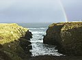
Brough /brɒx/ is a small village in Caithness on the far north coast of mainland Scotland. It is the most northerly village of mainland Great Britain. It is 10 miles east of Thurso, 20 miles north-west of Wick, 200 miles north of Edinburgh, and 500 miles north of London. It is on the southern shore of the Pentland Firth, the sea channel between Caithness and the Orkney Islands, notorious for strong tidal currents and exceptionally violent sea conditions. Brough is located on the B855 single-track road, 2.5 miles south east of Dunnet Head Lighthouse, the most northerly lighthouse and point on mainland Britain. The neighbouring village of Dunnet and the wide sandy beaches of Dunnet Bay lie 1.6 miles to the south. Brough is within the civil parish of Dunnet. John o' Groats, the north-easterly point of the mainland, lies 10 miles to the east.

The Mumbles Lifeboat Station is at Mumbles Pier, located at the south-western corner of Swansea Bay, near the village of Mumbles, within the city and county of Swansea, in the historic county of Glamorgan, Wales.

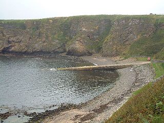
Angle Lifeboat Station is located near the village of Angle, on the southern side of the entrance to the Milford Haven Waterway in Pembrokeshire, Wales.

Walton and Frinton Lifeboat Station is a Royal National Lifeboat Institution (RNLI) station located in the town of Walton-on-the-Naze in the English county of Essex.

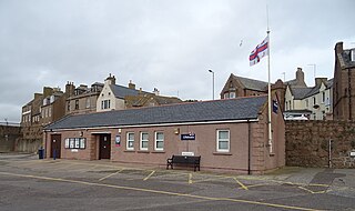
Eyemouth Lifeboat Station is located at the harbour town of Eyemouth, in the Scottish Borders, Scotland.

Whitby Lifeboat Station is a Royal National Lifeboat Institution (RNLI) lifeboat station located in Whitby, North Yorkshire, England. It is one of nine situated along the Yorkshire coast.

Anstruther Lifeboat Station is a Royal National Lifeboat Institution (RNLI) station located in the town of Anstruther, Fife. The station has been in operation since 1865, although RNLI activity in the area dates back to 1832.

Thurso Lifeboat Station is located at Scrabster Harbour, in the NE corner of Scotland, near the town of Thurso, Highland, in the historic county of Caithness.
A lifeboat was first stationed here by the Royal National Lifeboat Institution in 1860.

Longhope Lifeboat Station is the base for Royal National Lifeboat Institution (RNLI) search and rescue operations at Longhope on the island of South Walls, in Orkney, Scotland. It opened in 1874 and since 2004 has operated a Tamar-class lifeboat. In 1969 its lifeboat and crew of eight were lost during a rescue mission.

Ackergill Lifeboat Station is located at Ackergill Harbour, Highland, in the NE corner of Scotland near the town of Wick, in the historic county of Caithness.

Portpatrick Lifeboat Station is the base for Royal National Lifeboat Institution (RNLI) lifeboats at Portpatrick in Dumfries and Galloway, Scotland. It opened in 1877 and today operates an all-weather lifeboat.

Amble Lifeboat Station is located at Radcliffe Quay, Warkworth Harbour, in the town of Amble, at the mouth of the River Coquet, in the county of Northumberland.
Peterhead Lifeboat Station is located at West Pier, in the harbour town of Peterhead, in the NE corner of Aberdeenshire, Scotland.

Mallaig Lifeboat Station is located at Harbour Road in Mallaig, a harbour town at the top of the north Morar peninsula, on the north-west coast of Scotland.

Lochinver Lifeboat Station is located at Harbour Road in Lochinver, a harbour town at the head of Loch Inver, on the north-west coast of Scotland, formerly in Sutherland, now in the administrative region of Highland.

Ballyglass Lifeboat Station actually comprises two stations, an offshore station located at Ballyglass Pier on Broadhaven Bay, and an Inshore station 10 kilometres (6.2 mi) away, at Belmullet, both sitting on the Mullet Peninsula in County Mayo, on the north west coast of Ireland.

Huna Lifeboat Station was located at Huna, a hamlet on the north eastern tip of the Highland region of Scotland, historically Caithness, overlooking the Island of Stroma in the Pentland Firth, and sitting just over 1 mile (1.6 km) to the east of John o' Groats.