Slanci

Last updated • 3 min readFrom Wikipedia, The Free Encyclopedia
Slanci
Сланци
Location map Belgrade Central.png
Red pog.svg
Slanci
Location within Belgrade
Coordinates: 44°48′30″N20°34′17″E / 44.808451°N 20.571518°E / 44.808451; 20.571518 Coordinates: 44°48′30″N20°34′17″E / 44.808451°N 20.571518°E / 44.808451; 20.571518
Country Flag of Serbia.svg  Serbia
Region Belgrade
Municipality Palilula
Area
[1]
  Total10.70 km2 (4.13 sq mi)
Population
 (2011)
  Total1,782
  Density170/km2 (430/sq mi)
Time zone UTC+1 (CET)
  Summer (DST) UTC+2 (CEST)
Postal code
11215
Area code +381(0)11
Car plates BG

Slanci (Serbian Cyrillic : Сланци) is a suburban settlement of Belgrade, Serbia. It is located in the Belgrade's municipality of Palilula.

Contents

Location

Slanci is located in the eastern section of the Palilula municipality, 10 km (6.2 mi) from downtown Belgrade [2] and few kilometers east of the neighborhood of Višnjica on the road of Slanački put (Slanci road) which connects Belgrade with Veliko Selo, the easternmost settlement in the municipality of Palilula.

The settlement is built on the southern slopes of the hill of Milićevo brdo (279 m), in the micro-valley of the short creek of Vrelski potok. It is surrounded by the Pajstovica, Osovlje and Tapino hills, being tucked in on the southern side of the Danube ridge. [2]

Population

Historical population
YearPop.±%
19481,452    
19531,520+4.7%
19611,578+3.8%
19711,685+6.8%
19811,681−0.2%
19911,736+3.3%
20021,770+2.0%
20111,783+0.7%
Source: [3]

Population of Slanci is stagnating for decades: it had a population of 1,736 in 1991, 1,770 in 2002 and 1,783 in 1991. Serbs made 98% of the population according to the 2002 census.

Characteristics

The name of the settlement, which means "salty" in Serbian, comes from the many springs in the hills above, many of which have mildly salty water. Using the natural inclination, villagers built a water supply system in the 19th century, when many towns in Serbia had no waterworks. Due to the lack of maintenance, the old aqueduct collapsed in the late 1990s. [2]

In the expansion of the population of jackals in the outskirts of Belgrade since the 2000s, the jackals have been reported in Slanci in the early 2022. [4]

Monastery

A monastery of Slanci, dedicated to the Saint archdeacon Stefan, is located nearby. Original building was built in the late 13th century by King Dragutin after he received Belgrade and the northern Serbia from the Hungarian king. The monastery was originally dedicated to Mother of God. The area became part of the Serbian state again in 1403, during the rule of Stefan Lazarević who supported the monastery financially. During the reign of his successor, Đurađ Branković, the monastery was dedicated to the Saint Stephen, the saint protector of the Branković dynasty. The prosperity of the monastery was disrupted after the Ottoman conquest of Serbia in 1459. Ottomans killed 30 students in the monastery but the relics were partially moved to the Vojlovica monastery in then Hungary, across the Danube. In the next five centuries, the monastery was demolished and rebuilt several times. In 1900 a chapel was built on the location of the former monastery. In 1960 patriarch German set the foundation stone for the new monastery which was consecrated in 1967, together with the adjoining konak. [5] The monastery church was finished in 1970. In the vicinity of the monastery is the water spring named after Saint Sava. [6] Since the mid-1970s, the monastery is a metochion of the Hilandar monastery on the Mount Athos. Hilandar bestowed to Slanci a copy of its famed icon of Bogorodica Trojeručica, made in Karyes. [5] The monastery is protected both as the cultural monument and as an archaeological site. [6]

Economy

The settlement is officially classified as rural (village), as agriculture dominate its economy. As a typical representative of an urban agriculture, Slanci was previously known for the production of vegetables for the Balgrade markets. Although there are still some hoop houses, since the late 1990s the production is mostly fruit oriented: cherries, apricots, apples. [2]

In recent years, some industrial facilities (warehouses and concrete plants) are developing between Belgrade (Lešće) and Slanci, along the Slanci road.

Related Research Articles

Zemun Municipality in Belgrade, Serbia

Zemun is a municipality of the city of Belgrade. Zemun was a separate town that was absorbed into Belgrade in 1934. It lies on the right bank of the Danube river, upstream from downtown Belgrade. The development of New Belgrade in the late 20th century expanded the continuous urban area of Belgrade and merged it with Zemun.

Hilandar Serbian Orthodox monastery, Mount Athos, Greece

The Hilandar Monastery is one of the twenty Eastern Orthodox monasteries in Mount Athos in Greece and the only Serbian monastery there. It was founded in 1198 by Stefan Nemanja and his son Saint Sava. St. Symeon was the former Grand Prince of Serbia (1166-1196) who upon relinquishing his throne took monastic vows and became an ordinary monk. He joined his son Saint Sava who was already in Mount Athos and who later became the first Archbishop of Serbia. Upon its foundation, the monastery became a focal point of the Serbian religious and cultural life, as well as "the first Serbian university". It is ranked fourth in the Athonite hierarchy of 20 sovereign monasteries. The Mother of God through her Icon of the Three Hands (Trojeručica), is considered the monastery's abbess.

Borča Urban settlement in Belgrade, Serbia

Borča is an urban settlement of the municipality of Palilula, Belgrade, Serbia. As of 2011, it has a population of 46,086 inhabitants.

Smederevo City in Podunavlje, Serbia

Smederevo is a city and the administrative center of the Podunavlje District in eastern Serbia. It is situated on the right bank of the Danube, about 45 kilometres downstream of the Serbian capital, Belgrade.

Palilula is a municipality of the city of Belgrade. It has the largest area of all municipalities of Belgrade. The core of Palilula is close to the center of the city, but the municipality also includes sparsely populated land left of the Danube.

Irig, Serbia Town and municipality in Vojvodina, Serbia

Irig is a town and municipality located in the Srem District of the autonomous province of Vojvodina, Serbia. The town has a population of 4,415, while Irig municipality has 10,866 inhabitants.

Fruška Gora Mountain and national park in Serbia

Fruška gora is a mountain in Syrmia, administratively part of Serbia with a part of its western side extending into eastern Croatia. The area under Serbian administration forms the country's oldest national park. Sometimes it's also referred to as the Jewel of Serbia, due to its largely pristine landscape and protection effort, or the Serbian Mount Athos, it being the home of a large number of historical Serbian Orthodox monasteries.

Bač, Serbia Town and municipality in Vojvodina, Serbia

Bač is a town and municipality located in the South Bačka District of the autonomous province of Vojvodina, Serbia. The town has a population of 5,399, while Bač municipality has 14,405 inhabitants. The entire geographical region between the rivers Danube and Tisza, today divided between Serbia and Hungary, was named Bačka after the town.

Novi Bečej Town and municipality in Vojvodina, Serbia

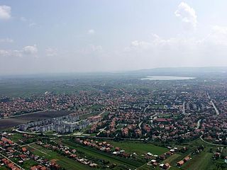
Novi Bečej is a town and municipality located in the Central Banat District of the autonomous province of Vojvodina, Serbia. The town has a population of 13,133, while Novi Bečej municipality has 23,925 inhabitants.

Ovča Suburban settlement in Palilula, Belgrade, Serbia

Ovča is a suburban settlement of Belgrade, the capital of Serbia. It is located to the northeast of the city, in the municipality of Palilula.

Crna Trava Village and municipality in Southern and Eastern Serbia, Serbia

Crna Trava is a village and municipality located in the Jablanica District of southern Serbia. According to 2011 census, the population of the village is 434 inhabitants, while population of the municipality is 1,663. This is the smallest by population and poorest municipality in Serbia.

Fenek Monastery

The Fenek Monastery is the male monastery in the eparchy of Srem of the Serbian Orthodox Church. The monastery is situated near the village of Јаkovo, 25 km from Belgrade, former Municipality of Zemun and now Surčin. Although geographically it does not belong to Fruška gora there is a huge historical connection with Fruška gora monasteries. The monastery church was dedicated to St. Martyr Paraskeva.

Golubac Fortress Fortified town near Golubac, Serbia

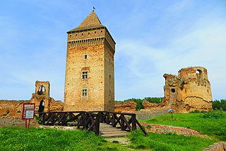
The Golubac Fortress was a medieval fortified town on the south side of the Danube River, 4 km (2.5 mi) downstream from the modern-day town of Golubac, Serbia. According to recent discoveries, the fortress, which was built during the 14th century by Medieval Serbian state, is split into three compounds which were built in stages. It has ten towers, most of which started square, and several of which received many-sided reinforcements with the advent of firearms. Towers were not connected for easier defense. Also inside the fortress were found Serbian Medieval frescos.

Pančevački Rit

Pančevački Rit is a small geographical area in south-western Banat, Serbia. It is situated between the rivers Danube and Tamiš, in Belgrade's municipality of Palilula.

Karaburma is an urban neighborhood of the municipality of Palilula, Belgrade, Serbia. As of 2002, it has a population of 55,343 inhabitants.

Kovilovo

Kovilovo is a suburban settlement of Belgrade, the capital of Serbia. It is located in the Belgrade's municipality of Palilula.

Subdivisions of Belgrade Place

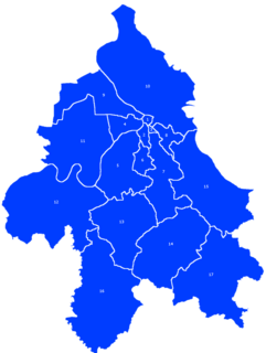
Serbia's capital city of Belgrade is divided into 17 municipalities.

Veliko Selo is a suburban settlement of Belgrade, Serbia. It is located in the Belgrade's municipality of Palilula.

Gardoš Urban neighbourhood in Zemun, Belgrade, Serbia

Gardoš is an urban neighborhood of Belgrade, the capital of Serbia. It is located in Belgrade's municipality of Zemun. Located on the slopes of the hill of the same name, with its tower and preserved old architecture, Gardoš is the major historical landmark of Zemun. Remnants of the Gardoš Fortress, built in the 14th century and the 15th century, are the oldest surviving parts of Zemun.

Kosmaj

Kosmaj is a mountain south of Belgrade, the capital of Serbia. With an elevation of 626 meters, it is the highest point of the entire Belgrade City area and is nicknamed one of two "Belgrade mountains".

References

  1. "Насеља општине Палилула" (PDF). stat.gov.rs (in Serbian). Statistical Office of Serbia. Retrieved 22 October 2019.
  2. 1 2 3 4 Milan Četnik, "Baštovandžije bez snaša i kafana", Politika (in Serbian)
  3. Comparative overview of the number of population in 1948, 1953, 1961, 1971, 1981, 1991, 2002 and 2011 – Data by settlements, page 29. Statistical Office of the Republic of Serbia, Belgrade. 2014. ISBN   978-86-6161-109-4.
  4. Ana Vuković (7 April 2022). "Šakali stigli i do grada" [Jackals reached the city]. Politika (in Serbian). p. 16.
  5. 1 2 "Stefandan u Slancima za hiljadu duša", Politika (in Serbian), 9 January 2013
  6. 1 2 Marija Brakočević, "Manastir Slanci - sigurno utočište", Politika (in Serbian)