
Corbridge is a village in Northumberland, England, 16 miles (26 km) west of Newcastle and 4 miles (6 km) east of Hexham. Villages nearby include Halton, Acomb, Aydon and Sandhoe.

Hexham is a market town and civil parish in Northumberland, England, on the south bank of the River Tyne, formed by the confluence of the North Tyne and the South Tyne at Warden nearby, and close to Hadrian's Wall. Hexham was the administrative centre for the Tynedale district from 1974 to 2009. In 2011, it had a population of 13,097.

Bedlington is a town and former civil parish in Northumberland, England, with a population of 18,470 measured at the 2011 Census.

Morpeth is a historic market town in Northumberland, England, lying on the River Wansbeck. Nearby towns include Ashington and Bedlington. In the 2011 census, the population of Morpeth was given as 14,017, up from 13,833 in the 2001 census. The earliest evidence of settlement is believed to be from the Neolithic period, and some Roman artifacts have also been found.

Newbiggin-by-the-Sea is a seaside town and civil parish in Northumberland, England, located on the North Sea coast.

Shotley Bridge is a village, adjoining the town of Consett to the south in County Durham, England, 15 miles northwest of Durham.

Allendale, often marked on maps as Allendale Town, is a village and civil parish in south west Northumberland, England. It is located within the North Pennines Area of Outstanding Natural Beauty.

Bardon Mill is a small village in Northumberland, within the vicinity of the ancient Hadrian's Wall. It is located around 10+1⁄2 miles from Hexham, 26+1⁄2 mi (43 km) from Carlisle, and 32 mi (51 km) from Newcastle upon Tyne.

Hindley is a small hamlet, comprising around 20 residences. It is in the parish of Stocksfield and is just to the south of Stocksfield in Northumberland with Broomley to the west and Whittonstall to the east. It is south of the River Tyne. Hindley is composed of a large house, Hindley Hall, a farm and a post box.

Thurlby is a village and civil parish in the South Kesteven district of Lincolnshire, England. It is situated just west of the A15 road, 2 miles (3 km) south from the town of Bourne, and on the edge of the Lincolnshire Fens. It is sometimes referred to as Thurlby by Bourne to distinguish it from other villages in Lincolnshire with the same name. Thurlby and the hamlet of Northorpe to its north are conjoined. The parish had a population of 2,136 at the 2001 census and 2,153 at the 2011 census.

Advent is a civil parish on the north-western edge of Bodmin Moor in north Cornwall, England, United Kingdom. The English name St Adwenna derives from the Cornish Adhwynn and lies in the Registration District of Camelford.

The Diocese of Newcastle is a Church of England diocese based in Newcastle upon Tyne, covering the historic county of Northumberland, as well as the area of Alston Moor in Cumbria.

Enville is a village and civil parish in rural Staffordshire, England, on the A458 road between Stourbridge and Bridgnorth.
Shotley is a village and civil parish 8 miles (13 km) south-east of Ipswich in the English county of Suffolk. It is in the Babergh district and gives its name to the Shotley peninsula between the Rivers Stour and Orwell. The parish includes the village of Shotley and the settlements of Shotley Gate and Church End. In 2011 civil parish had a population of 2,342. In reference to the 2021 census, the population of Shotley was 550.

Winlaton is a village situated in the Metropolitan Borough of Gateshead, Tyne and Wear, England. Historically in County Durham, it was incorporated into the metropolitan county of Tyne and Wear and Borough of Gateshead in 1974. In 2011 the village was absorbed into the Gateshead MBC ward of Winlaton and High Spen. The population of this ward at the 2011 census was 8,342.

Chelmondiston is a small village and civil parish in Suffolk, England located on the Shotley Peninsula, five miles south-east of Ipswich. The hamlet of Pin Mill lies within the parish on the south bank of the River Orwell. The village comprises approximately 500 dwellings and has a population of just over 1,000. It is one of the largest villages situated on the Shotley Peninsula.

Tattingstone is a village and civil parish in Suffolk, England. It is situated on the Shotley peninsula, about 5 miles (8 km) south of Ipswich. The 2011 Census recorded the population as 540.

Great Whittington is a village and former civil parish, now in the parish of Whittington, in Northumberland, England, 7 miles NE of Hexham. In 1951 the parish had a population of 158, in 2011 it had a population of 401.

Longhorsley is a village in Northumberland, England about 7 miles (11 km) northwest of Morpeth, and about 14 miles (23 km) south of Alnwick. The A697 road passes through the village linking it with Morpeth, Wooler and Coldstream in Scotland. There are 8 "Streets" in Longhorsley: Whitegates, Church View, Drummonds Close, South Road, West Road, East Road and Reivers Gate, Wilding Place and .The village is bordered on the north by the River Coquet. The village formerly lay in three separate townships: Bigges Quarter, Freeholders Quarter and Riddells Quarter.

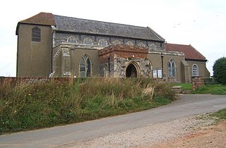
St Andrew's Church, Shotley, is a redundant Anglican church standing in an isolated position at a height of 960 feet (293 m) on Greymare Hill in Northumberland, England. It is recorded in the National Heritage List for England as a designated Grade II listed building, and is in the care of the Churches Conservation Trust.


