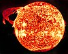
A solar flare is a sudden flash of increased brightness on the Sun, usually observed near its surface and in close proximity to a sunspot group. Powerful flares are often, but not always, accompanied by a coronal mass ejection. Even the most powerful flares are barely detectable in the total solar irradiance.

Space weather is a branch of space physics and aeronomy, or heliophysics, concerned with the time varying conditions within the Solar System, including the solar wind, emphasizing the space surrounding the Earth, including conditions in the magnetosphere, ionosphere, thermosphere, and exosphere. Space weather is distinct from but conceptually related to the terrestrial weather of the atmosphere of Earth. The term space weather was first used in the 1950s and came into common usage in the 1990s. Similar to terrestrial climatology, the long term patterns of space weather comprise space climate.

A geomagnetic storm is a temporary disturbance of the Earth's magnetosphere caused by a solar wind shock wave and/or cloud of magnetic field that interacts with the Earth's magnetic field. The increase in the solar wind pressure initially compresses the magnetosphere. The solar wind's magnetic field interacts with the Earth's magnetic field and transfers an increased energy into the magnetosphere. Both interactions cause an increase in plasma movement through the magnetosphere and an increase in electric current in the magnetosphere and ionosphere.
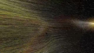
A coronal mass ejection (CME) is a significant release of plasma and accompanying magnetic field from the solar corona. They often follow solar flares and are normally present during a solar prominence eruption. The plasma is released into the solar wind, and can be observed in coronagraph imagery.

Deep Space Climate Observatory is a NOAA space weather, space climate, and Earth observation satellite. It was launched by SpaceX on a Falcon 9 launch vehicle on February 11, 2015, from Cape Canaveral.
Space environment is a branch of astronautics, aerospace engineering and space physics that seeks to understand and address conditions existing in space that affect the design and operation of spacecraft. A related subject, space weather, deals with dynamic processes in the solar-terrestrial system that can give rise to effects on spacecraft, but that can also affect the atmosphere, ionosphere and geomagnetic field, giving rise to several other kinds of effects on human technologies.
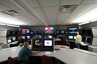
The Space Weather Prediction Center (SWPC), named the Space Environment Center (SEC) until 2007, is a laboratory and service center of the US National Weather Service (NWS), part of the National Oceanic and Atmospheric Administration (NOAA), located in Boulder, Colorado. SWPC continually monitors and forecasts Earth's space environment, providing solar-terrestrial information. SWPC is the official source of space weather alerts and warnings for the United States.

Suzaku was an X-ray astronomy satellite developed jointly by NASA's Goddard Space Flight Center and the Institute of Space and Aeronautical Science at JAXA to probe high energy X-ray sources, such as supernova explosions, black holes and galactic clusters. It was launched on 10 July 2005 aboard the M-V-6 rocket. After its successful launch, the satellite was renamed Suzaku after the mythical Vermilion bird of the South.
The Lockheed Martin Solar and Astrophysics Laboratory (LMSAL) is part of the Lockheed Martin Advanced Technology Center (ATC) that is known primarily for its scientific work in the field of solar physics, astronomy and space weather. The LMSAL team is part of Lockheed Martin Space Systems and has close affiliations with NASA and the solar physics group at Stanford University.

Solar Cycle 24 is the 24th solar cycle since 1755, when extensive recording of solar sunspot activity began. It is the current solar cycle, and began in December 2008 with a smoothed minimum of 2.2. Activity was minimal until early 2010. It reached its maximum in April 2014 with a smoothed sunspot number of only 81.8, the lowest since the Dalton Minimum. Reversed polarity polar active sunspot regions in December 2016, April 2018, and November 2018 indicate that a transitional phase to solar cycle 25 is in process.

Hitomi, also known as ASTRO-H and New X-ray Telescope (NeXT), was an X-ray astronomy satellite commissioned by the Japan Aerospace Exploration Agency (JAXA) for studying extremely energetic processes in the Universe. The space observatory was designed to extend the research conducted by the Advanced Satellite for Cosmology and Astrophysics (ASCA) by investigating the hard X-ray band above 10 keV. The satellite was originally called New X-ray Telescope; at the time of launch it was called ASTRO-H. After it was placed in orbit and its solar panels deployed, it was renamed Hitomi. The new name refers to the pupil of an eye, and to a legend of a painting of four dragons, two of which were given eyes and flew into the sky, and two that were left eyeless and stayed as motionless art. The spacecraft was launched on 17 February 2016 and contact was lost on 26 March 2016, due to multiple incidents with the attitude control system leading to an uncontrolled spin rate and breakup of structurally weak elements.

The Joint Polar Satellite System (JPSS) is the latest generation of U.S. polar-orbiting, non-geosynchronous, environmental satellites. JPSS will provide the global environmental data used in numerical weather prediction models for forecasts, and scientific data used for climate monitoring. JPSS will aid in fulfilling the mission of the U.S. National Oceanic and Atmospheric Administration (NOAA), an agency of the Department of Commerce. Data and imagery obtained from the JPSS will increase timeliness and accuracy of public warnings and forecasts of climate and weather events, thus reducing the potential loss of human life and property and advancing the national economy. The JPSS is developed by the National Aeronautics and Space Administration (NASA) for the National Oceanic and Atmospheric Administration (NOAA), who is responsible for operation of JPSS. Three to five satellites are planned for the JPSS constellation of satellites. JPSS satellites will be flown, and the scientific data from JPSS will be processed, by the JPSS - Common Ground System (JPSS-CGS).

GOES-16, formerly known as GOES-R before reaching geostationary orbit, is the first of the GOES-R series of Geostationary Operational Environmental Satellite (GOES) operated by NASA and the National Oceanic and Atmospheric Administration (NOAA). GOES-16 serves as the operational geostationary weather satellite in the GOES East position at 75.2°W, providing a view centered on the Americas. GOES-16 provides high spatial and temporal resolution imagery of the Earth through 16 spectral bands at visible and infrared wavelengths using its Advanced Baseline Imager (ABI). GOES-16's Geostationary Lightning Mapper (GLM) is the first operational lightning mapper flown in geostationary orbit. The spacecraft also includes four other scientific instruments for monitoring space weather and the Sun.

The Halloween solar storms were a series of solar flares and coronal mass ejections that occurred from mid-October to early November 2003, peaking around October 28–29. This series of storms generated the largest solar flare ever recorded by the GOES system, modeled as strong as X45. Satellite-based systems and communications were affected, aircraft were advised to avoid high altitudes near the polar regions, and a one-hour-long power outage occurred in Sweden as a result of the solar activity. Aurorae were observed at latitudes as far south as Texas and the Mediterranean countries of Europe.
Solar cycle 25 is the upcoming and 25th solar cycle since 1755, when extensive recording of solar sunspot activity began. It is expected to begin in late 2019 and continue through 2030. The first Cycle 25 sunspot may have appeared in early April 2018 or even December 2016.

GOES-17 is the second of the current generation of weather satellites operated by the National Oceanic and Atmospheric Administration (NOAA). The four satellites of the series will extend the availability of the GOES until 2036 for weather forecast and meteorology research. The satellite was built by Lockheed Martin, was based on the A2100A platform, and will have an expected useful life of 15 years. The satellite was launched on 1 March 2018 and reached geostationary orbit on 12 March 2018. In May 2018, during the satellite's testing phase after launch, a problem was discovered with its primary instrument, the Advanced Baseline Imager. GOES-17 became operational as GOES-West on 12 February 2019. GOES-17 is currently operating alongside GOES-15 but will replace it in July 2019.
NOAA-20, designated JPSS-1 prior to launch, is the first of the United States National Oceanic and Atmospheric Administration's latest generation of U.S. polar-orbiting, non-geosynchronous, environmental satellites called the Joint Polar Satellite System. NOAA-20 was launched on November 18, 2017 and joined the Suomi National Polar-orbiting Partnership satellite in the same orbit. NOAA-20 operates about 50 minutes ahead of Suomi NPP, allowing important overlap in observational coverage. Circling the Earth from pole-to-pole, it crosses the equator about 14 times daily, providing full global coverage twice a day. This will give meteorologists information on "atmospheric temperature and moisture, clouds, sea-surface temperature, ocean color, sea ice cover, volcanic ash, and fire detection" so as to enhance weather forecasting including hurricane tracking, post-hurricane recovery by detailing storm damage and mapping of power outages.