Solomon Rapids, Kansas

Last updated

Solomon Rapids, Kansas
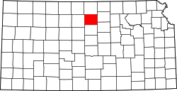
Map of Mitchell Co, Ks, USA.png
USA Kansas location map.svg
Red pog.svg
Solomon Rapids
Usa edcp location map.svg
Red pog.svg
Solomon Rapids
Coordinates: 39°28′25″N98°11′33″W / 39.47361°N 98.19250°W / 39.47361; -98.19250 [1]
Country United States
State Kansas
County Mitchell
Elevation
[1]
1,394 ft (425 m)
Time zone UTC-6 (CST)
  Summer (DST) UTC-5 (CDT)
Area code 785
FIPS code 20-66425
GNIS ID 472328 [1]

Solomon Rapids is an unincorporated community in Mitchell County, Kansas, United States. [1]

Contents

History

A post office was opened in Solomon Rapids in 1870, and remained in operation until it was discontinued in 1953. [2] The community took its name from rapids on the nearby Solomon River. [3]

Education

The community is served by Beloit USD 273 public school district.

See also

Related Research Articles

<span class="mw-page-title-main">Osborne County, Kansas</span> County in Kansas, United States

Osborne County is a county located in the U.S. state of Kansas. It county seat and largest city is Osborne. As of the 2020 census, the county population was 3,500. The county is named for Vincent Osborne, a captain in the American Civil War.

<span class="mw-page-title-main">Mitchell County, Kansas</span> County in Kansas, United States

Mitchell County is a county located in the U.S. state of Kansas. Its county seat and largest city is Beloit. As of the 2020 census, the county population was 5,796. The county was named for William Mitchell.

<span class="mw-page-title-main">Cloud County, Kansas</span> County in Kansas, United States

Cloud County is a county located in the U.S. state of Kansas. Its county seat and most populous city is Concordia. As of the 2020 census, the county population was 9,032. The county was named after William Cloud, an officer in the American Civil War.

<span class="mw-page-title-main">Beloit, Kansas</span> City in Mitchell County, Kansas

Beloit is a city in and the county seat of Mitchell County, Kansas, United States. As of the 2020 census, the population of the city was 3,404.

<span class="mw-page-title-main">Glen Elder, Kansas</span> City in Mitchell County, Kansas

Glen Elder is a city in Mitchell County, Kansas, United States. As of the 2020 census, the population of the city was 362.

<span class="mw-page-title-main">Simpson, Kansas</span> City in Mitchell and Cloud Counties in Kansas

Simpson is a city in Cloud and Mitchell counties in Kansas, United States. As of the 2020 census, the population of the city was 82.

<span class="mw-page-title-main">Solomon, Kansas</span> City in Dickinson and Saline Counties of Kansas

Solomon is a city in Dickinson and Saline counties in the U.S. state of Kansas. As of the 2020 census, the population of the city was 993. It is located approximately 6 miles west of Abilene.

<span class="mw-page-title-main">Asherville, Kansas</span> Unincorporated community in Mitchell County, Kansas

Asherville is an unincorporated community in Mitchell County, Kansas, United States. As of the 2020 census, the population of the community and nearby areas was 19.

<span class="mw-page-title-main">Browns Creek Township, Jewell County, Kansas</span> Township in Kansas, United States

Browns Creek Township is a township in Jewell County, Kansas, USA. As of the 2000 census, its population was 64.

<span class="mw-page-title-main">Prairie Township, Jewell County, Kansas</span> Township in Kansas, United States

Prairie Township is a township in Jewell County, Kansas, USA. As of the 2000 census, its population was 172.

<span class="mw-page-title-main">Mitchell, Kansas</span> Unincorporated community in Rice County, Kansas

Mitchell is an unincorporated community in Rice County, Kansas, United States. Located about 6 miles (9.7 km) east-northeast of the city of Lyons, it lies along local roads a fraction of a mile north of U.S. Route 56.

<span class="mw-page-title-main">Kipp, Kansas</span> Unincorporated community in Saline County, Kansas

Kipp is an unincorporated community on the border between Eureka and Solomon townships in Saline County, Kansas, United States. As of the 2020 census, the population of the community and nearby areas was 60. It is located southeast of Salina along Schilling Road between Whitmore Road and Kipp Road, next to an abandoned railroad.

<span class="mw-page-title-main">Bloomington, Kansas</span> Unincorporated community in Osborne County, Kansas

Bloomington is an unincorporated community in Osborne County, Kansas, United States. It is located about 4 miles west of Osborne.

<span class="mw-page-title-main">Niles, Kansas</span> Unincorporated community in Ottawa County, Kansas

Niles is an unincorporated community in Ottawa County, Kansas, United States. As of the 2020 census, the population of the community and nearby areas was 56.

Verdi is an unincorporated community in Ottawa County, Kansas, United States.

<span class="mw-page-title-main">Angelus, Kansas</span> Unincorporated community in Sheridan County, Kansas

Angelus is an unincorporated community in Sheridan County, Kansas, United States. It is located in Solomon Township, approximately 20 miles southwest of Hoxie. Also, it is located northwest of Grinnell and Interstate 70.

<span class="mw-page-title-main">Studley, Kansas</span> Unincorporated community in Sheridan County, Kansas

Studley is an unincorporated community in Sheridan County, Kansas, United States, approximately 16 miles east of Hoxie along U.S. Route 24. It is on the eastern edge of the county in Valley Township, bordering Graham County. It was named after the Studley Royal Park, in England.

<span class="mw-page-title-main">Webster, Kansas</span> Unincorporated community in Rooks County, Kansas

Webster was an unincorporated community in Belmont Township, Rooks County, Kansas, United States.

<span class="mw-page-title-main">Tasco, Kansas</span> Unincorporated community in Sheridan County, Kansas

Tasco is an unincorporated community in Sheridan County, Kansas, United States. It is located about 7 miles east of Hoxie and south of U.S. Route 24 highway, next to an abandoned railroad.

Glen Elder Township is a township in Mitchell County, Kansas, USA.

References

  1. 1 2 3 4 "Solomon Rapids, Kansas", Geographic Names Information System , United States Geological Survey, United States Department of the Interior
  2. "Kansas Post Offices, 1828-1961 (archived)". Kansas Historical Society. Archived from the original on October 9, 2013. Retrieved June 15, 2014.{{cite web}}: CS1 maint: unfit URL (link)
  3. "Origin of Town Names" (PDF). Solomon Valley Highway 24 Heritage Alliance. p. 2. Retrieved April 9, 2018.

Further reading