Victor, Kansas | |
|---|---|
 | |
 Victor  Victor | |
| Coordinates: 39°14′53″N98°17′02″W / 39.24806°N 98.28389°W [1] | |
| Country | United States |
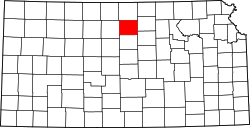
| State | Kansas |
| County | Mitchell |
| Elevation | 1,496 ft (456 m) |
| Population | |
• Total | 0 |
| Time zone | UTC-6 (CST) |
| • Summer (DST) | UTC-5 (CDT) |
| Area code | 785 |
| FIPS code | 20-73740 [1] |
| GNIS ID | 484603 [1] |
Victor is a ghost town in Blue Hills Township, Mitchell County, Kansas, United States. [1]