
Garnett is a city in and the county seat of Anderson County, Kansas, United States. As of the 2020 census, the population of the city was 3,242.
Glasco is a city in Cloud County, Kansas, United States. As of the 2020 census, the population of the city was 441.

Mulberry is a city in Crawford County, Kansas, United States. As of the 2020 census, the population of the city was 409.

Lansing is a city in Leavenworth County, Kansas, United States. It is situated along the west side of the Missouri River and Kansas-Missouri state border. As of the 2020 census, the population of the city was 11,239. It is the second most populous city of Leavenworth County and is a part of the Kansas City metropolitan area. The Lansing Correctional Facility, which includes the state's main maximum-security prison, is located in Lansing.

Sylvan Grove is a city in Lincoln County, Kansas, United States. As of the 2020 census, the population of the city was 291.

Lyndon is a city in, and the county seat of Osage County, Kansas, United States. As of the 2020 census, the population of the city was 1,037.

Minneapolis is a city in and the county seat of Ottawa County, Kansas, United States. As of the 2020 census, the population of the city was 1,946.

Atwood is a city in and the county seat of Rawlins County, Kansas, United States. As of the 2020 census, the population of the city was 1,290.

Belleville is a city in and the county seat of Republic County, Kansas, United States. As of the 2020 census, the population of the city was 2,007.

Narka is a city in Republic County, Kansas, United States. As of the 2020 census, the population of the city was 81.
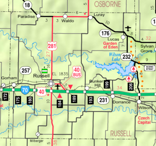
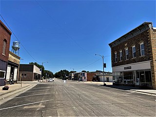
Lucas is a city in Russell County, Kansas, United States. As of the 2020 census, the population of the city was 332.
Luray is a city in Russell County, Kansas, United States. As of the 2020 census, the population of the city was 166.

Andale is a city in Sedgwick County, Kansas, United States. As of the 2020 census, the population of the city was 941.

Clearwater is a city in Sedgwick County, Kansas, United States. As of the 2020 census, the population of the city was 2,653.
Mount Hope is a city in Sedgwick County, Kansas, United States. As of the 2020 census, the population of the city was 806.

Lebanon is a city in Smith County, Kansas, United States. As of the 2020 census, the population of the city was 178.

Argonia is a city in Sumner County, Kansas, United States. As of the 2020 census, the population of the city was 456.

Mayfield is a city in Sumner County, Kansas, United States. As of the 2020 census, the population of the city was 75.

Alma is a city in and the county seat of Wabaunsee County, Kansas, United States. As of the 2020 census, the population of the city was 802.

Lake Quivira is a city in Johnson and Wyandotte counties in the State of Kansas, and part of the Kansas City Metropolitan Area. As of the 2020 census, the population of the city was 1,014.


