
Cibola County is a county in the U.S. state of New Mexico. As of the 2020 census, the population was 27,172. Its county seat is Grants. It is New Mexico's youngest county, and the third youngest county in the United States, created on June 19, 1981, from the westernmost four-fifths of the formerly much larger Valencia County.

Acomita Lake is a census-designated place (CDP) in Cibola County, New Mexico, United States. The population was 339 at the 2020 census.

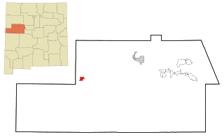
Encinal is a census-designated place (CDP) in Cibola County, New Mexico, United States. It is the smallest of the six villages of the Laguna Pueblo and sits at the base of Mount Taylor. The population was 210 at the 2010 census.

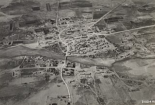
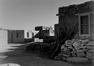
Laguna is a census-designated place (CDP) on the Laguna Pueblo in Cibola County, New Mexico, United States. The population was 1,241 at the 2010 census. It is located approximately 47 miles west of Albuquerque.

North Acomita Village is a census-designated place (CDP) in Cibola County, New Mexico, United States. The population was 303 at the 2010 census.

Paguate is a census-designated place (CDP) in Cibola County, New Mexico, United States. The population was 421 at the 2010 census.

Paraje is a census-designated place (CDP) in Cibola County, New Mexico, United States. As of the 2010 census, the CDP population was 777.
Pinehill or Pine Hill is a census-designated place in Cibola County, New Mexico, United States. It is located on the Ramah Navajo Indian Reservation. The population was 88 at the 2010 census. The location of the CDP in 2010 had become the location of the Mountain View CDP as of the 2020 census, while a new CDP named "Pinehill" was listed 8 miles (13 km) further south, at a point 4 miles (6 km) southeast of Candy Kitchen.

Seama is a census-designated place (CDP) in Cibola County, New Mexico, United States. The population was 465 at the 2010 census.

Skyline-Ganipa is a census-designated place (CDP) in Cibola County, New Mexico, United States. The population was 1,224 at the 2010 census.
Zuni Pueblo is a census-designated place (CDP) in McKinley County, New Mexico, United States. The population was 6,302 as of the 2010 Census. It is inhabited largely by members of the Zuni people.
The Pueblo of Acoma is an Indian reservation of the Acoma Pueblo peoples located in parts of Cibola, Socorro, and Catron counties, in New Mexico, the Southwestern United States. It covers 594.996 sq mi (1,541.033 km2). The reservation borders the Laguna Indian Reservation to the east and is near El Malpais National Monument due west.
Mountain View is a census-designated place (CDP) in Cibola County, New Mexico, United States. It is located on the Ramah Navajo Indian Reservation. In 2010 the location was listed as the Pinehill census-designated place. It was first listed as the Mountain View CDP prior to the 2020 census.

Fence Lake is a census-designated place located in southwestern Cibola County, New Mexico, United States. Designated in 1980 by the United States Census Bureau, Fence Lake had a population of 42 as of the 2010 census. The area is largely ranchland, and there are few businesses there. It was named after a small village which is contained within its boundaries.
Anzac Village is a census-designated place (CDP) in Cibola County, New Mexico, United States. The population was 54 at the 2010 census.
Las Tusas is a census-designated place (CDP) in Cibola County, New Mexico, United States. At the 2010 census the CDP was known as Bluewater Acres and had a population of 206.
McCartys Village is a census-designated place (CDP) in Cibola County, New Mexico, consisting of the unincorporated community known as McCartys. The population was 48 at the time of the 2010 census. It is part of the Acoma Pueblo.
Moquino is a census-designated place (CDP) in Cibola County, New Mexico, United States. The population was 37 at the 2010 census.
El Morro Valley is a census-designated place (CDP) in Cibola County, New Mexico, United States. It includes El Morro National Monument and the unincorporated community of El Morro. The area was first listed as a CDP prior to the 2020 census.
Mount Taylor is a census-designated place (CDP) in Cibola County, New Mexico, United States. It was first listed as a CDP prior to the 2020 census.

