South Cross Route (SCR) was the designation for the southern section of Ringway 1, the innermost circuit of the London Ringways network, a complex and comprehensive plan for a network of high speed roads circling and radiating out from central London designed to manage and control the flow of traffic within the capital.
The SCR was planned during the late 1960s along with the rest of the Ringway scheme but was never constructed due to large scale opposition from many quarters. The construction work required to pass a six-lane dual carriageway with grade separated junctions through the congested streets of south London would have been enormous and devastating to the communities through which it passed.
Route
Plan of the London Motorway Box scheme from mid 1960s showing the South Cross Route, Balham Loop and "South Cross Route to Parkway D Radial"
The SCR would have started in Battersea at the south-west corner of Ringway 1 where it would have had a junction with the West Cross Route coming south-east across the River Thames from Earl's Court. The junction was planned to be located on the triangle of land between the railway lines around Falcon Park and crossing Latchmere Road (A3220). The junction would also have had a connection westwards to a feeder motorway to the planned terminus of the M3 motorway and the actual terminus of the M4 motorway at Gunnersbury. It is possible that this motorway would have been designated as a continuation of the M4.
In the mid-1960s the Ringways plan also included a motorway, known as the Balham Loop, heading south-west from the triangular junction through Clapham Junction station, then south towards Balham and east to Tulse Hill. This route was omitted from the plans in 1967.
Heading east, the SCR would have followed the route of the National Rail main line heading into Waterloo station crossing the tracks south-west of Queenstown Road station. Here the SCR would have had a junction with Queenstown Road (A3216) and passed over the railway and industrial land there to head south-east towards Heathbrook Park and Wandsworth Road station. The SCR would then have followed the south side of the line, requiring the demolition of most of the east side of Edgeley Road, then past Clapham High Street station to a junction with Clapham High Street (A3).
Continuing east, the SCR would have claimed much of the north side of Ferndale Road as well as most, if not all, of Dolman, Glendall and Bythorn Streets, three short cul-de-sacs between Ferndale Road and the railway tracks. The SCR would have next reached a difficult section through Brixton town centre where a complexity of railway tracks branching and crossing above one another to follow different routes, Brixton station and the narrow shopping streets would have needed considerable demolition to make a route for the elevated SCR. In conjunction with the road scheme, the Greater London Council proposed a scheme for the almost total clearance and reconstruction of the town centre including the construction of more than a dozen 50-storey blocks of flats as well as widespread low-rise residential and commercial projects. Just as the road itself attracted objections, the redevelopment of the town centre met with considerable local opposition and virtually none of the proposals were implemented.
For a while, the destruction planned for Brixton town centre would have been even greater. It was intended to locate a junction here to connect the SCR to a motorway running south-east along the railway line to Herne Hill and then to South Norwood and a probable terminal on Ringway 3 at or near Addington. This motorway, known to the road planners as the "South Cross Route to Parkway D Radial" was still part of the Ringways Plan in 1969 but had been cancelled by 1972 along with the southern section of Ringway 2.
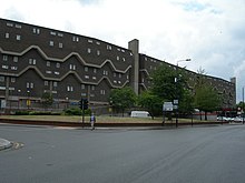
Southwyck House in Brixton was specifically designed to shield the housing estate behind it from the noise of Ringway 1
East of Brixton Road (A23), the SCR would have followed Coldharbour Lane and passed the north side of the Moorland Estate where the council block on the north side, Southwyck House, is a relic of the GLC redevelopment scheme and was designed to present a barrier to protect the estate beyond from the noise of the elevated motorway.
Crossing the southbound railway line from Blackfriars station, the SCR would have continued east, requiring further demolitions on the south side of the Loughborough Junction triangle to reach Ruskin Park. East of Ruskin Park the SCR would have passed along Champion Park between Denmark Hill station and the Salvation Army's William Booth College.
East of Denmark Hill station the south side of the railway line to the next station at Peckham Rye was, in the late 1960s, a relatively wide and clear embankment and would have provided the space for another road junction, connecting either to Grove Lane or possibly across the railway to Peckham Road via Vestry Road and Lucas Gardens. In recent years a number of residential developments have been constructed in this area.
For its route through Peckham the SCR would have claimed Blenheim Grove on the south side of the station and more industrial land to its east before following the railway to Nunhead station on an alignment where the wide area of railway land to the south of the tracks would have provided a route requiring only limited demolition, mainly to the north side of Kimberley Avenue. To the east of Nunhead station, the SCR would have crossed two further sets of railway tracks - one branching south-east to Crofton Park and the other the line between New Cross Gate and Brockley stations. Again, when the SCR was planned, this section was an uninterrupted alignment for the motorway to follow but it has since been developed with residential infill schemes.
East of the New Cross Gate railway tracks the railway land continues to be wide enough for the SCR to have passed with only limited demolition works required as it headed towards Lewisham town centre. At Lewisham the SCR would have merged with a spur from the north-west that was planned to run 0.75 miles along the New Cross railway line to end at a junction on New Cross Road (A2). The SCR would have crossed to the north side of the railway to skirt the town centre passing through industrial and commercial areas and crossing over the route now occupied by the Docklands Light Railway. Residential demolitions would have been required at the west end of Granville Park to clear the path but the route was then clear to Blackheath station.
East of Blackheath station the SCR looped south-east to follow the railway line through the north side of Blackheath Park, where some demolitions would have been necessary, before skirting the sports ground and Kidbrooke station to meet the junction of the East Cross Route coming south from the Blackwall Tunnel, the A2 Rochester Way Relief Road coming east from Eltham and the A20 coming north from Mottingham.
At this junction, the south-east corner of the London Motorway Box traffic would have been directed on to the A2 with slip roads providing connections to and from the A20 and the East Cross Route.
Balham Loop
The purpose of the Balham Loop motorway was to provide a connection between Ringway 1 and the M23 motorway running through south London. Other incoming motorways, such as the M1 and M11, were intended to terminate directly on the innermost Ringway, but the route of the M23 through south London was considerably more difficult than the M1's route through north London and there was no simple or direct route for the M23 to reach Ringway 1 in Clapham. Instead, the Balham Loop would have acted as a distributor road connecting to the West Cross Route and SCR at Battersea and to the SCR at Brixton, via the "South Cross Route to Parkway D Radial".
Leaving the junction of the West Cross Route and SCR heading south-west, the Balham Loop would have passed over the railway land at Clapham Junction station before heading south to cross the A3 at Battersea Rise then run parallel with the railway across Wandsworth Common to cross Nightingale Lane (B229) and past Wandsworth Common station.
It is not certain which side of the railway the motorway would have run but the south side of the railway through Balham is likely to have offered the road planners the easier route. At Tooting Common the Balham Loop would have had a Y-shaped junction with the end of the M23 motorway coming north from Streatham Vale and would then have continued through Streatham Hill, over the A23 and then would have cut through a residential area to reach the triangular railway junction south of Tulse Hill station. Here the Balham Loop would have met the "South Cross Route to Parkway D Radial" motorway and traffic would have had the option of turning north-east towards Brixton or south-east to West Norwood.
The Balham Loop was cancelled in 1967 when it was decided that the M23 would be terminated further south on Ringway 2 at Streatham Vale.
South Cross Route to Parkway D Radial
The "South Cross Route to Parkway D Radial" motorway was due to start on the SCR at Brixton and run south-east out of London to Ringway 3. The route was an early omission from the developing Ringways plans and the alignment in the outer suburbs is uncertain. The cumbersome name reflects the reuse of an earlier route proposal from Sir Patrick Abercrombie'sCounty of London Plan, 1943. The Ringway plan's Ringway 3 equated to Parkway D from Abercrombie's plan. The use of the obsolete terminology suggests that the planning for this road was not a top priority for the road planners.
From the SCR the radial motorway would have first followed the railway line south-east past Herne Hill and Brockwell Park to Tulse Hill, West Norwood and Crystal Palace station where it would have turned and headed south along the line towards South Norwood Country Park, which in the 1960s was a sewage works. From here the route is uncertain but it would have probably crossed Addiscombe and Shirley to reach Addington and Ringway 3.
The SCR and the other roads planned in the 1960s for central London had developed from early schemes prior to the Second World War through Sir Patrick Abercrombie's County of London Plan, 1943 and Greater London Plan, 1944 to a 1960s Greater London Council (GLC) scheme that would have involved the construction of many miles of motorway standard roads across the city and demolition on a massive scale. Due to the huge construction costs and widespread public opposition, most of the scheme including the SCR was cancelled in 1973. Only the East Cross Route, part of the West Cross Route and the Westway were built.
The M25 or London Orbital Motorway is a major road encircling most of Greater London. The 117-mile (188-kilometre) motorway is one of the most important roads in the UK and one of the busiest. Margaret Thatcher opened the final section in 1986, making the M25 the longest ring road in Europe upon opening. The Dartford Crossing completes the orbital route but is not classed as motorway; it is classed as a trunk road and designated as the A282. In some cases, including notable legal contexts such as the Communications Act 2003, the M25 is used as a de facto alternative boundary for Greater London.
The Westway is a 2.5-mile (4 km) elevated dual carriageway section of the A40 trunk road in West London running from Paddington in the east to North Kensington in the west. It connects the London Inner Ring Road to the West London suburbs.
The A23 road is a major road in the United Kingdom between London and Brighton, East Sussex, England. It is managed by Transport for London for the section inside the Greater London boundary, Surrey County Council and West Sussex County Council for the section shadowed by the M23 motorway, National Highways between the M23 and Patcham, and by Brighton and Hove Council from the A27 to the centre of Brighton.
The M23 is a motorway in the United Kingdom, running from the south of Hooley in Surrey, where it splits from the A23, to Pease Pottage, south of Crawley in West Sussex where it rejoins the A23. The northern end of the motorway starts on what is effectively a 2-mile (3.2 km) spur north of junction 7 of the M25 motorway. From Hooley it runs for 17 miles (27 km) past Redhill, Gatwick Airport and Crawley. A spur runs from junction 9 to Gatwick Airport.
The South London line is a railway line in inner south London, England. The initial passenger service on the route was established by the London, Brighton & South Coast Railway on 1 May 1867 when the central London terminal stations of Victoria and London Bridge were connecting to the inner south London suburbs of Clapham, Brixton, Camberwell and Peckham. Since 2012 passenger services have been part of London Overground and run between Clapham Junction and Peckham Rye continuing toward Highbury & Islington via the East London line. The line is 8.5 miles (13.7 km) long and consists of seven stations, one of which marks the crossover into the East London line network. Most of the line was built on a high level viaduct above other transport infrastructure. Interchanges with the London Underground are at Clapham High Street and the closest on its London Overground extension is Canada Water. The line is in Travelcard Zone 2.
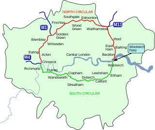
The South Circular Road in south London, England, is a major road that runs from the Woolwich Ferry in the east to the Chiswick Flyover in the west via Eltham, Lee Green, Catford, Forest Hill, Dulwich, Tulse Hill, Clapham Common, Clapham Junction, Wandsworth, Putney, Barnes, Mortlake and Kew Bridge. Together with the North Circular Road and Woolwich Ferry, it makes a complete ring-road around Central London and forms the boundary of the Ultra Low Emission Zone. The South Circular is largely a sequence of urban streets joined together, requiring several at-grade turns, unlike the mostly purpose-made carriageways of the North Circular. As a result, it is frequently congested.
The A24 is a major road in England that runs for 53.2 miles (85.6 km) from Clapham in south-west London to Worthing on the English Channel in West Sussex via the suburbs of south-west London, as well as through the counties of Surrey and West Sussex.
The West London line is a short railway in inner West London that links Clapham Junction in the south to Willesden Junction in the north. The line has always been an important cross-London link especially for freight services. Southern and London Overground provide regular passenger services; detailed below.
The Brighton Main Line is a major railway line in the United Kingdom that links Brighton, on the south coast of England, with central London. In London the line has two branches, out of London Victoria and London Bridge stations respectively, which join up in Croydon and continue towards Brighton as one line. The line is electrified throughout using the third rail system.
Norwood Junction railway station is a National Rail station in South Norwood in the London Borough of Croydon, south London, and is in Travelcard Zone 4. It is 8 miles 55 chains down the line from London Bridge.
The County of London Plan was prepared for the London County Council in 1943 by John Henry Forshaw (1895–1973) and Sir Leslie Patrick Abercrombie (1879–1957)
The West Cross Route (WCR) is a 0.75 mile segment of dual carriageway of the A3220 route in West London running north–south between the northern elevated roundabout junction with the western end of Westway (A40) and the southern Holland Park Roundabout. It runs through Shepherd's Bush to its west and Notting Hill to its east.
Balham is an interchange station formed of a range of underground entrances for the London Underground ('tube') and a shared entrance with its National Rail station component. The station is in central Balham in the London Borough of Wandsworth, south London, England. The tube can be accessed on each side of the Balham High Road (A24); National Rail on the south side of the road leading east, where the track is on a mixture of light-brick high viaduct and earth embankment, quadruple track and on a brief east–west axis.
Crossrail 2 is a proposed hybrid commuter rail and rapid transit route in South East England, running from nine stations in Surrey to three in Hertfordshire, providing a new North–South rail link across Greater London. It would connect the South West Main Line to the West Anglia Main Line, via Victoria and King's Cross St Pancras. It is intended to alleviate severe overcrowding that would otherwise occur on commuter rail routes into Central London by the 2030s. Should permission be granted, construction is expected to start around 2023, with the new line opening from the early 2030s. The project's cost has been estimated at £31.2 billion.
East Cross Route (ECR) is a dual-carriageway road constructed in east London as part of the uncompleted Ringway 1 as part of the London Ringways plan drawn up the 1960s to create a series of high speed roads circling and radiating out from central London. The road was constructed between 1967 and 1973 and runs from Hackney Wick in north-east London, through the Blackwall Tunnel, to Kidbrooke in south-east London. The ECR was initially designated as part of the A102, but has, subsequently, been partially renumbered so that sections of it are now the A2 and A12.
The London Ringways were a series of four ring roads planned in the 1960s to circle London at various distances from the city centre. They were part of a comprehensive scheme developed by the Greater London Council (GLC) to alleviate traffic congestion on the city's road system by providing high speed motorway-standard roads within the capital, linking a series of radial roads taking traffic into and out of the city.
North Cross Route (NCR) was a planned motorway-standard road which would have formed the northern section of Ringway 1 and would have formed the innermost circuit of the London Ringways network. The six-lane dual carriageway with grade separated junctions to an extended M1 motorway was planned during the late 1960s along with the rest of the Ringway scheme. It was never constructed due to large-scale opposition from many quarters.
The A3220 is a primary A road in London, England. It runs north from Clapham Common to the A40 Westway at Ladbroke Grove.
East Brixton railway station was a railway station in Brixton, south London. It was opened as Loughborough Park by the London, Brighton & South Coast Railway in 1866. Regular passenger service was the South London line from London Victoria to London Bridge terminal stations in central London. Initially provided with a steam passenger service, competition from electric trams caused a conversion to overhead line electric operation in 1909. The station became part of the Southern Railway in 1923 and overhead line electrification was swapped for third rail in 1928. The station lost patronage after the opening of Brixton Underground station in 1971. There was a fire at the station in 1975 and it was closed by British Rail in January 1976. The station was located next to the rail bridge over Barrington Road, near Coldharbour Lane. Since 2012 London Overground trains pass through the site of the former station without stopping and there has been some campaigning to reopen it.
This page is based on this Wikipedia article Text is available under the CC BY-SA 4.0 license; additional terms may apply. Images, videos and audio are available under their respective licenses.