

The South Ferry Basin is a tidal basin on the River Mersey, in England, and part of the Port of Liverpool. Situated near the southern dock system, it is only connected directly to the river.
The South Ferry Basin is a tidal basin on the River Mersey, in England, and part of the Port of Liverpool. Situated near the southern dock system, it is only connected directly to the river.
The basin was built c.1817–23 for use by fishermen and ferries. [1] Around 1817, the Etna was built for ferrying passengers and vehicles from South Ferry Basin to Tranmere. [2] From 4 April 1865 a ferry service was established between the South Ferry Basin and New Ferry on the Wirral Peninsula, with additional sailings to Liverpool Pier Head. Facilities at the basin consisted of a pontoon moored against the dock wall. The "South End" service appeared to be relatively short-lived, as by 1876, these facilities had been removed and sold for scrap. [3]
This small basin was also known locally as the 'Cocklehole' and was a place that Liverpool ceded to the poor cocklefishers and oystercatchers for the mooring and repair of their boats whilst the main port of Liverpool handled the large trade. It was little known under its own name and often confused as being part of Coburg Dock. [4]
It is a little basin between Coburg Dock and the Brunswick Half Tide, and there, for a little while longer, beneath an old-world quay, brown sails dip softly in a quiet haven. Fishermen sit and smoke above them, nets hang in the sun, low buildings with broken, domestic roofs run round a cobbled square; and in one corner a pier-master's cottage has its ivy, its curtains, its canary in a wicker cage. It is a relic that serves only to italicize the change.
— said of South Ferry Basin by Dixon Scott in 1907 [5]
The basin is open to the river and is currently heavily silted up. It isn't used for anything. Although the basin remains unaltered, the surrounding area has since been redeveloped for residential purposes.

The Pier Head is a riverside location in the city centre of Liverpool, England. It is part of the Liverpool Maritime Mercantile City UNESCO World Heritage Site, which was inscribed in 2004. As well as a collection of landmark buildings, recreational open space, and a number of memorials, the Pier Head was the landing site for passenger ships travelling to and from the city.

Hornby Dock was a dock located on the River Mersey, England, and part of the Port of Liverpool. It was situated in the northern dock system in Bootle. It connected to Gladstone Dock to the north and Alexandra Dock to the south and encompassed a sloping quayside.

Alexandra Dock is a dock on the River Mersey, England, and part of the Port of Liverpool. It is situated in the northern dock system in Bootle. Alexandra Dock consists of a main basin nearest the river wall and three branch docks to the east, with the southern branch mostly filled in.

Langton Dock is a dock on the River Mersey, England, and part of the Port of Liverpool. It is situated in the northern dock system in Bootle, connected to Alexandra Dock to the north and Brocklebank Dock to the south. Langton Dock locks provide a working connection to the river; one of the two remaining operational river entrances in the northern dock system.

Huskisson Dock is a dock on the River Mersey, England, which forms part of the Port of Liverpool. It is situated in the northern dock system in Kirkdale. Huskisson Dock consists of a main basin nearest the river wall and two branch docks to the east. It is connected to Canada Dock to the north and Sandon Half Tide Dock to the south.

Nelson Dock is a dock on the River Mersey, England, and part of the Port of Liverpool. It is situated in the northern dock system in Vauxhall, connected to Bramley-Moore Dock to the north and Salisbury Dock to the south.

Prince's Half-Tide Dock on the River Mersey, England, is a half tide dock and part of the Port of Liverpool. It is situated in the northern dock system in Vauxhall, connected to East Waterloo Dock and West Waterloo Dock to the north and Prince's Dock to the south.

Prince's Dock is a dock on the River Mersey, England, and part of the Port of Liverpool. It is the most southerly of the docks situated in the northern part of the Liverpool dock system, connected to Prince's Half-Tide Dock to the north. The dock is now in the buffer zone to one of Liverpool's World Heritage Sites.
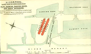
Canning Dock on the River Mersey is part of the Port of Liverpool in Northern England. The dock is in the southern dock system, connected to Salthouse Dock to the south and with access to the river via the Canning Half Tide Dock to the west. The Canning Graving Docks are accessed from the dock.

Salthouse Dock is a dock on the River Mersey, England, and part of the Port of Liverpool. It is situated in the southern dock system, connected to Canning Dock to the north, Wapping Dock via Wapping Basin to the south and Albert Dock to the west.

Coburg Dock is a dock on the River Mersey, in England, and part of the Port of Liverpool. It is situated in the southern dock system, connected to Queens Dock to the north, Brunswick Dock to the south.

Brunswick Dock is a dock on the River Mersey, in England, and part of the Port of Liverpool. It is situated in the southern dock system, connected to Coburg Dock to the north, Toxteth Dock to the south.

Harrington Dock was a dock on the River Mersey and part of the Port of Liverpool. Situated in the southern dock system, it was connected to Toxteth Dock to the north and Herculaneum Dock to the south.

Duke's Dock is a dock on the River Mersey, England, and part of the Port of Liverpool. It is in the southern dock system, connected to Salthouse Dock and Wapping Dock to the east. The Albert Dock is located immediately north, although not directly accessible by water.

Canning Half Tide Dock on the River Mersey, in Liverpool, England, is a half tide dock and is part of the Port of Liverpool. It is situated in the southern dock system, connected to Canning Dock to the east and Albert Dock to the south.

Brunswick Half Tide Dock on the River Mersey, England, was a half tide dock and part of the Port of Liverpool. Situated near Brunswick Dock in the southern dock system, it only connected directly to the river.

The Old Dock, originally known as Thomas Steers' dock, was the world's first commercial wet dock. The 3 1⁄2 acres (1.4 ha) dock was built on the River Mersey in Liverpool, England, starting in 1710 and completed in 1716. A natural tidal pool off the river Mersey, which probably gave its name to Liverpool centuries earlier, was partially filled and locked in from the river with quay walls erected.

The Mersey Docks and Harbour Company (MDHC), formerly the Mersey Docks and Harbour Board (MDHB), owns and administers the dock facilities of the Port of Liverpool, on the River Mersey, England. These include the operation of the enclosed northern dock system that runs from Prince's Dock to Seaforth Dock, in the city of Liverpool and the dock facilities built around the Great Float of the Wirral Peninsula, located on the west side of the river.

Sandon Dock was a dock on the River Mersey, England, and part of the Port of Liverpool. Situated in the northern dock system, it was east of Sandon Half Tide Dock, to which it was once connected.
Chester Basin was a tidal basin on the River Mersey, in Liverpool, England. The basin was situated between the Pier Head and Manchester Dock.
| Wikimedia Commons has media related to South Ferry Basin . |