Southern Zanzibar–Inhambane coastal forest mosaic

Last updated
Southern Zanzibar-Inhambane coastal forest mosaic
Makonde Plateau escarpment.JPG
Makonde Plateau escarpment, at the northern edge of the ecoregion
Global 200 - Eastern Africa Coastal Forests, northern & southern.jpg
  Southern Zanzibar-Inhambane coastal forest mosaic
Ecology
Realm Afrotropical
Biome Tropical and subtropical moist broadleaf forests
Borders
Geography
Area144,800 km2 (55,900 sq mi)
Countries Mozambique and Tanzania
Coordinates 16°15′S39°42′E / 16.25°S 39.7°E / -16.25; 39.7 Coordinates: 16°15′S39°42′E / 16.25°S 39.7°E / -16.25; 39.7
Conservation
Conservation status Critical/endangered
Global 200 Coastal forests of eastern Africa
Protected14.24% [1]

The Southern Zanzibar-Inhambane coastal forest mosaic, also known as the Southern Swahili coastal forests and woodlands, [2] is a tropical moist broadleaf forest ecoregion of eastern Africa. It is a southern variation of Northern Zanzibar-Inhambane coastal forest mosaic. The ecoregion supports habitats of forest, savanna and swamps. The southern portion of the ecoregion is not as well studied due to the 1977-1992 civil war in Mozambique.

Contents

Geography

The ecoregion extends along the coast of Tanzania and Mozambique, from Tanzania's Lukuledi River south almost the whole way to the mouth of the Limpopo River.

It is mostly coastal, generally within 50 km of the Indian Ocean. It encompasses coastal lowlands, rolling hills, and isolated plateaus and inselbergs, including the Rondo and Makonde plateaus in southern Tanzania, the Mueda Plateau in northern Mozambique. [3]

It includes some isolated mountainous enclaves further inland, including Mount Chiperone, Mount Mabu, Mount Morrumbala, Mount Namuli, and Mount Tumbine in northern Mozambique, and the southeastern slopes of the Eastern Highlands, including Moribane forest. The mountains intercept humid southwesterly winds from the Indian Ocean, which form clouds and rain and create a cooler, wetter climate than the surrounding lowlands. These mountains are home to lowland evergreen forests with a similar flora to the coastal lowland forests, and higher-elevation montane forests, woodlands, grasslands, and heathlands which are home to many Afromontane species. [4] The WWF scheme follows Frank White's 1983 "Vegetation Map of Africa" by including these inland mountains in the coastal forest mosaic ecoregion. Other researchers, including Jonathan Timberlake of Kew Gardens, maintain that the flora and fauna of Northern Mozambique's interior inselbergs, especially at higher elevations, have greater affinity with the Afromontane Eastern Arc forests. [5] [6]

The ecoregion is bounded on the east by the Indian Ocean. To the north, it abuts the Northern Zanzibar-Inhambane coastal forest mosaic. It transitions to drier open woodlands to the west – the Eastern miombo woodlands at the northern end, the Zambezian and mopane woodlands in the central portion, and the Southern miombo woodlands at the southern end. To the south, it borders the Maputaland coastal forest mosaic. It also includes some small offshore islands in Mozambique, including the Quirimbas Islands and Bazarruto Archipelago.

Climate

The climate is tropical in the northern portion, becoming sub-tropical at the southern end. In the area around Lindi in Tanzania there is one long dry season and one wet season. Rainfall is 800–1000 mm per year, and is higher on some of the plateaus and mountains. The climate is similar in the Mozambican portion, although rainfall is lower (800 mm) in northern Mozambique, which is in the rain shadow of Madagascar. Mean maximum temperatures are 30-27 °C in the north and 24 °C in the south, and mean minimum temperature is 18-15 °C throughout the ecoregion. [7]

Flora

The vegetation of the ecoregion is a mosaic of tropical moist forest, tropical dry forest, thicket, miombo woodland, grassland, and wetland.

Dry forests and thickets are found in the northern portion of the ecoregion. This region, comprising southeastern Tanzania and northeastern Mozambique, is in the rain shadow of Madagascar, and rainfall is lower (less than 1000 mm annually) than in the coastal forests to the north and south. The dry forests have a closed canopy, with a large proportion of deciduous species that lose their leaves in the long and hot dry season. Dense thickets form where dry forests have been disturbed by human activity. Dry forests are typically found on soils derived from iron-rich sandstone and conglomerates of the Mikindani Formation. Typical dry forest tree species in Mozambique's Cabo Delgado province include Manilkara sansibarensis , Warneckea sansibarica , Baphia macrocalyx , and Pteleopsis myrtifolia . 738 plant species were identified from the dry forests of Cabo Delgado. The plant families with the most species include Rubiaceae with 84 species, Leguminaceae subfamilies Papilionoideae (43 species), Mimosoideae (29 species), and Caesalpinioideae (24 species), and Euphorbiaceae (41 species), Apocynaceae (28 species), and Lamiaceae (28 species). Human activity has fragmented the dry forests into small patches, and it is estimated that 80% have been lost in the last 100 to 150 years. [8]

The Rondo, Chitoa, and Makonde plateaus and adjacent coastal lowlands of southeastern Tanzania, at the northern end of the ecoregion, are home to at least 76 endemic species of plants, along with several endemic species and subspecies of animals. The region is known as the Lindi sub-centre of endemism. [9]

Fauna

Large mammals include the African bush elephant (Loxodonta africana), African buffalo (Syncerus caffer), sable antelope (Hippotragus niger), roan antelope (H. equinus), and Lichtenstein's hartebeest (Alcelaphus buselaphus lichtensteinii), which also inhabit the adjacent Eastern miombo woodlands. Vincent's bush squirrel (Paraxerus vincenti) is endemic to Mount Namuli in Mozambique. [7]

The northernmost portion of the ecoregion around Lindi in Southeastern Tanzania, including coastal forests and the Rondo, Chitoa, and Makonde plateaus, is home to several endemic and limited range species. These include the southern population of the primate Rondo dwarf galago (Paragalago rondoensis), the endemic birds Reichenow's batis (Batis reichenowi) and an endemic subspecies of green barbet (Stactolaema olivacea hylophona), the reptiles Melanoceps rondoensis , Scolecoseps litapoensis , Typhlops rondoensis , and Chirindia rondoensis , and two endemic butterfly species. [9] The forests of the Lindi region are also home to populations of lemon dove (Columba larvata), green-headed oriole (Oriolus chlorocephalus), and black-fronted bushshrike (Chlorophoneus nigrifrons), species generally found in montane forests further inland. [10]

The Namuli apalis (Apalis lynesi) is a bird endemic to Mount Namuli.

The skinks Scelotes duttoni, Scelotes insularis , and Lygosoma lanceolatum are endemic to the Bazaruto Archipelago. [9]

Protected areas

14.24% of the ecoregion is in protected areas. [1] Protected areas within the ecoregion include:

See also

Related Research Articles

Geography of Mozambique

The geography of Mozambique consists mostly of coastal lowlands with uplands in its center and high plateaus in the northwest. There are also mountains in the western portion. The country is located on the east coast of southern Africa, directly west of the island of Madagascar. Mozambique has a tropical climate with two seasons, a wet season from October to March and a dry season from April to September.

The Global 200 is the list of ecoregions identified by WWF, the global conservation organization, as priorities for conservation. According to WWF, an ecoregion is defined as a "relatively large unit of land or water containing a characteristic set of natural communities that share a large majority of their species dynamics, and environmental conditions". So, for example, based on their levels of endemism, Madagascar gets multiple listings, ancient Lake Baikal gets one, and the North American Great Lakes get none.

Eastern Highlands mountain range in Zimbabwe and Mozambique

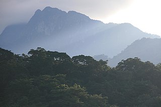
The Eastern Highlands, also known as the Manica Highlands, is a mountain range on the border of Zimbabwe and Mozambique. The Eastern Highlands extend north and south for about 300 kilometres (190 mi) through Zimbabwe's Manicaland Province and Mozambique's Manica Province.

Maputaland coastal forest mosaic Subtropical moist broadleaf forest ecoregion on the Indian Ocean coast of Southern Africa.

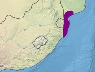
The Maputaland coastal forest mosaic is a subtropical moist broadleaf forest ecoregion on the Indian Ocean coast of Southern Africa. It covers an area of 29,961 square kilometres (11,568 sq mi) in southern Mozambique, Eswatini, and the KwaZulu-Natal Province of South Africa. Mozambique's capital Maputo lies within the ecoregion.

Coastal forests of eastern Africa

The Coastal forests of eastern Africa, also known as the East African Coastal Forests, is a tropical moist forest region along the east coast of Africa. The region was designated a biodiversity hotspot by Conservation International.

Eastern miombo woodlands

The Eastern miombo woodlands (AT0706) are an ecoregion of grassland and woodland in northern Mozambique, southern Tanzania, and southeastern Malawi.

Wildlife of Mozambique

The wildlife of Mozambique consists of the flora and fauna of this country in southeastern Africa. Mozambique has a range of different habitat types and an ecologically rich and diverse wildlife. This includes 236 species of mammal, 740 species of bird and 5,692 species of vascular plant. The Maputaland-Pondoland-Albany hotspot, with significantly high levels of biodiversity, stretches from the southern tip of Mozambique into northeastern South Africa.

The Lukuledi is a river in The United Republic Of Tanzania, south-eastern region of Africa. With a total length of 160 km, it rises from the boundary between the Lindi and Mtwara regions.

Northern Zanzibar–Inhambane coastal forest mosaic

Northern Zanzibar–Inhambane coastal forest mosaic, also known as the Northern Swahili coastal forests and woodlands, is a tropical moist broadleaf forest ecoregion of coastal East Africa. The ecoregion includes a variety of habitats, including forest, savanna and swamps.

Zambezian and mopane woodlands Tropical and subtropical grasslands, savannas, and shrublands ecoregion of southeastern Africa.

The Zambezian and mopane woodlands is a tropical and subtropical grasslands, savannas, and shrublands ecoregion of southeastern Africa.

Eastern Arc forests

The Eastern Arc forests is a montane tropical moist forest ecoregion of eastern Africa. The ecoregion comprises several separate highland areas above 800 meters in Kenya, and (mostly) Tanzania.

Rondo Plateau

The Rondo Plateau, also known as the Muera Plateau, is a high and extensive massif in the Lindi Region and northern Mtwara Region of southeastern of Tanzania. A portion of the plateau is protected by the Rondo Forest Reserve. It is one of a group of dissected plateaus lying between the Mbwemburu and Lukuledi rivers. It is approximately 60 km inland from Lindi, and is situated 15 km north of the Masasi road. It was revealed as an important biodiversity site in studies conducted since the 1980s.

Makonde Plateau

The Makonde Plateau, also known as the Newala Plateau, is a plateau in southeastern Tanzania. It is mostly within Mtwara Region, with the northeast corner in Lindi Region.

Mueda Plateau

The Mueda Plateau, also known as the Maconde Plateau, is a plateau in Cabo Delgado Province of northeastern Mozambique.

Mount Morrumbala Mountain in Mozambique

Mount Morrumbala, also known as Mount Tembe, is a mountain in Morrumbala District of Zambezia Province in central Mozambique.

Cheringoma Plateau

The Cheringoma Plateau is a low plateau in Sofala Province of Mozambique. It lies mostly within Cheringoma, Muanza, and Marromeu districts.

Southern miombo woodlands

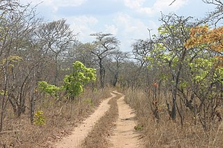
The Southern miombo woodlands is a tropical grasslands and woodlands ecoregion extending across portions of Malawi, Mozambique, Zambia, and Zimbabwe.

Western Congolian forest–savanna mosaic

The Western Congolian forest–savanna mosaic is an ecoregion of Angola, Democratic Republic of the Congo, Republic of the Congo, and Gabon.

References

  1. 1 2 "Southern Zanzibar-Inhambane coastal forest mosaic". DOPA Explorer. Accessed 24 January 2021.
  2. Eric Dinerstein, David Olson, et al. (2017). An Ecoregion-Based Approach to Protecting Half the Terrestrial Realm, BioScience, Volume 67, Issue 6, June 2017, Pages 534–545, https://doi.org/10.1093/biosci/bix014
  3. Burgess, Neil, Jennifer D’Amico Hales, Emma Underwood (2004). Terrestrial Ecoregions of Africa and Madagascar: A Conservation Assessment. Island Press, Washington DC.
  4. "Southern Zanzibar-Inhambane Coastal Forest Mosaic". Worldwide Fund for Nature. Accessed 24 June 2018.
  5. Timberlake, J.R., Dowsett-Lemaire, F., Bayliss, J., Alves T., Baena, S., Bento, C., Cook, K., Francisco, J., Harris, T., Smith, P. & de Sousa, C. (2009). Mt Namuli, Mozambique: Biodiversity and Conservation. Report produced under the Darwin Initiative Award 15/036. Royal Botanic Gardens, Kew, London. 114 p.
  6. Conradie W, Bittencourt-Silva GB, Engelbrecht HM, Loader SP, Menegon M, Nanvonamuquitxo C, Scott M, Tolley KA (2016) "Exploration into the hidden world of Mozambique’s sky island forests: new discoveries of reptiles and amphibians." Zoosystematics and Evolution 92(2): 163-180.
  7. 1 2 "Southern Zanzibar-Inhambane coastal forest mosaic". Terrestrial Ecoregions. World Wildlife Fund.
  8. Timberlake, Jonathan & Goyder, David & Chase, Frances & Burrows, John & Clarke, G. & Luke, Quentin & Matimele, Hermenegildo & Müller, Tom & Pascal, Olivier & Sousa, Camila & Alves, Tereza. (2011). Coastal dry forests in northern Mozambique. Plant Ecology and Evolution. 144. 126-137. 10.5091/plecevo.2011.539.
  9. 1 2 3 Burgess, N.D., Clarke, G.P., Rodgers, W.A. (1998) "Coastal forests of eastern Africa: status, endemism patterns and their potential causes". Biological Journal of the Linnean Society (1998), 64: 337-367.
  10. Jensen, Flemming P., Anders P. Tøttrup, and Kim D. Christensen (2005). "The avifauna of coastal forests in southeast Tanzania". Scopus 25: 1–22, December 2005.