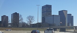
Southfield is a city in Oakland County in the U.S. state of Michigan. As of the 2020 census, the city had a population of 76,618.

Oadby and Wigston is a local government district and borough in the county of Leicestershire, England. It was formed in 1974, under the Local Government Act 1972, from the merger of the Oadby and Wigston urban districts. The population of the district at the 2011 census was 56,170. The district forms part of the Harborough constituency.
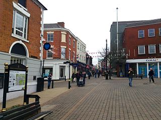
Hinckley and Bosworth is a local government district with borough status in south-western Leicestershire, England, administered by Hinckley and Bosworth Borough Council. Its only towns are Hinckley, Earl Shilton and Market Bosworth. Villages include Barwell, Burbage, Stoke Golding, Groby, Shackerstone and Twycross. The population of the Borough at the 2011 census was 105,078.
Evington is an area of Leicester, and electoral ward of the Leicester district, in the ceremonial county of Leicestershire, England. It used to be a small village centred on Main Street and the Anglican church of St Denys but was close enough to Leicester to become one of the outer suburbs in the 1930s. Today, the ward comprises the historical village of Evington, as well as the modern ex-council estates of Rowlatts Hill and Goodwood. The population of the ward at the 2011 census was 11,133.

The A5199 road is the direct road from Northampton to Leicester in England. It was formerly part of the A50 trunk road that ran from Bedfordshire to Lancashire. For most of its length it is known as the Welford Road, except for small stretches near Welford where it is known as High Street and Northampton Road, and a section near Wigston Magna where it is known as Bull Head Street.

Leicester West is a constituency represented in the House of Commons of the UK Parliament since 2010 by Liz Kendall of the Labour Party. Along with the other two Leicester seats, it was held by Labour at the 2017 general election. Since its creation in 1918 the seat has sided with parties from the left wing of politics.

Beaumont Leys is a suburb and electoral ward in north-western Leicester, in the Leicester district, in the ceremonial county of Leicestershire, England. The population of the ward at the 2011 census was 16,480. Locally, Beaumont Leys is usually used in reference to the large housing estate, built within the administrative division, centred on Strasbourg Drive.

Highfields is an inner city area of Leicester, England. It is one of the highest areas in the city, on high ground southeast of the city centre. To the west the area is bounded by the Midland Main Line, to the south by London Road (A6), and to the east by East Park Road. To the north is Spinney Hills, though there is no clear boundary between the two areas, and Spinney Hills is often considered to be part of Highfields. The neighbourhood is within walking distance of the city centre of Leicester and offers many amenities for religious, social, cultural and commercial activities. The population is split between the Spinney Hills, Wycliffe and Stoneygate wards of the Leicester City Council.

Leicester City Centre is Leicester's historical commercial, cultural and transport hub and is home to its central business district. Its inner core is roughly delineated by the A594, Leicester's inner ring road, although the various central campuses of the University of Leicester, De Monfort University and Leicester College are adjacent to the inner ring road and could be considered to be a continuation of the City centre. In a similar way, the Leicester Royal Infirmary precinct, the New Walk business district (Southfields), the Welford Road Stadium of Leicester Tigers' RUFC and the King Power Stadium of Premier League Leicester City to the south, and the Golden Mile to the north could also be deemed to be extensions to the central core.

The A594 Central Ring is the name of Leicester's central distributor road network.

Clarendon Park is an area in the south of the city of Leicester. It is bordered by Welford Road to the west, London Road to the east, Victoria Park to the north and Avenue Road/Avenue Road Extension to the south. It is part of Castle Ward and the constituency of Leicester South. There are two major shopping streets; Queens Road and Clarendon Park Road. These two roads intersect near the centre of Clarendon Park, with Queens Road running north–south, and Clarendon Park Road running east–west.

Braunstone is a civil parish and is the largest parish within the district of Blaby in Leicestershire, England, now known as the Town of Braunstone or more commonly, Braunstone Town. In 2007 the population was around 15,000. There are around 7,500 households including Thorpe Astley. At the 2011 census the population of the civil parish had increased to 16,850.

Leicester City Council is a unitary authority responsible for local government in the city of Leicester, England. It consists of 54 councillors, representing 22 wards in the city, overseen by a directly elected mayor. It is currently controlled by the Labour Party and has been led by Mayor Sir Peter Soulsby since his election on 6 May 2011. The main council building is City Hall on Charles Street, but council meetings are held in the 19th-century Town Hall.
The Strays of York is a collective name for four areas of open land, comprising in all over 800 acres (3.2 km2), within the City of York. Their individual names are Bootham Stray, Micklegate Stray, Monk Stray and Walmgate Stray.
Western Park is a park and surrounding suburb located in West End of Leicester. It is also a ward of the City of Leicester whose population at the 2011 census was 10,609.
Leicester College is a further education college in Leicester, England. It is one of the largest colleges in the UK, with more than 26,000 students, 1,600 staff, plus an annual budget of over £50million. It has three main campuses in the city centre, and more than 200 community venues across Leicester.
Newfoundpool is an area of Leicester lying south of the former Leicester and Swannington Railway. The land was purchased by market gardener Isaac Harrison in around 1830. Harrison intended to develop the area as a spa, using a spring as the source of water for a Hydrotherapy and bathing establishment, but the venture failed after a few years. Later the building was converted into a residence, Newfoundpool House, in which successive members of the Harrison family lived until 1885, with the land passing to Harrison's nephew, also named Isaac, and then his daughter Beatrice. The house became the Empire Hotel on Fosse Road North.

South Park is a 7.9 hectare park in the London Borough of Hammersmith and Fulham. South Park contains a public cricket pitch, tennis courts, football pitches, netball and basketball courts. In addition there is a large children's playground fenced off from the main park and a 1 km perimeter walk used by runners, walkers, dogs and their owners. Many people enjoy South Park for its unique trees and well maintained gardens. A nursery for 2-5 year olds operates out of the cricket pavilion.

Charnwood was an electoral ward and administrative division of the city of Leicester, England. The population of the ward at the 2011 census was 13,291. It comprised the northern Leicester suburb of Northfields and its Tailby and Morton ex-council estates. Northfields has had a bad reputation for criminal activities. Despite being only 3 small estates it was responsible for 30% of the crime rate within the Leicester area. In response The Northfields Project was set upin order to help to combat crime and make Northfields a safer place to live. The scheme improved areas such as security fencing, lighting and public recreational spaces.

Braunstone Park & Rowley Fields is an electoral ward and administrative division of the city of Leicester, England. It comprises the western Leicester suburbs of Braunstone Frith, Braunstone Park and Rowley Fields.
