
The Borough of Charnwood is a local government district with borough status in the north of Leicestershire, England, which has a population of 166,100 as of the 2011 census. It borders Melton to the east, Harborough to the south east, Leicester and Blaby to the south, Hinckley and Bosworth to the south west, North West Leicestershire to the west and Rushcliffe in Nottinghamshire to the north. It is named after Charnwood Forest, an area which the borough contains much of.
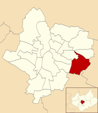
Evington is an area of Leicester, and electoral ward of the Leicester district, in the ceremonial county of Leicestershire, England. It used to be a small village centred on Main Street and the Anglican church of St Denys but was close enough to Leicester to become one of the outer suburbs in the 1930s. Today, the ward comprises the historical village of Evington, as well as the modern ex-council estates of Rowlatts Hill and Goodwood. The population of the ward at the 2011 census was 11,133.
Stoneygate is part of the City of Leicester, England.
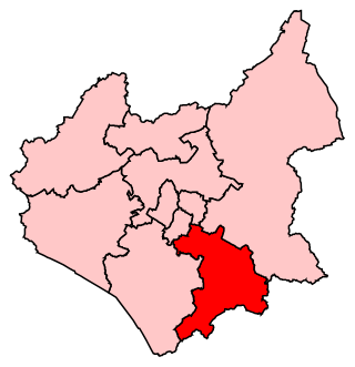
Leicester South is a constituency, recreated in 1974, represented in the House of Commons of the UK Parliament since 2011 by Jonathan Ashworth of the Labour Co-op Party. A previous version of the seat existed between 1918 and 1950. Except for a 2004 by-election when it was won by the Liberal Democrats, Leicester South has been held by the Labour Party since 1987.
Harborough is a constituency covering the south east of Leicestershire represented in the House of Commons of the UK Parliament since 2017 by Neil O'Brien of the Conservative Party.
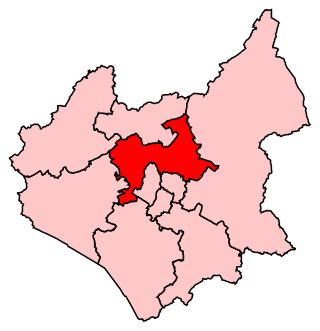
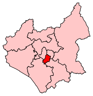
Charnwood is a constituency in Leicestershire represented in the House of Commons of the UK Parliament since 2015 by Edward Argar, a Conservative.

Leicester West is a constituency represented in the House of Commons of the UK Parliament since 2010 by Liz Kendall of the Labour Party. Along with the other two Leicester seats, it was held by Labour at the 2017 general election. Since its creation in 1918 the seat has sided with parties from the left wing of politics.

Leicester East is a constituency represented in the House of Commons of the UK Parliament since December 2019 by Claudia Webbe, who was elected as a Labour MP, but now sits as an Independent due to her suspension and subsequent expulsion from the party in November 2021 after she was convicted of harassment.

Wolverhampton North East is a borough constituency represented in the House of Commons of the Parliament of the United Kingdom. It elects one Member of Parliament (MP) by the first past the post system of election. It is currently represented by Jane Stevenson of the Conservative Party, who was elected at the 2019 general election.
Rowlatts Hill is an eastern, residential suburb of the English city of Leicester. It contains mostly council-owned housing.
Evington Valley is an area in Leicester, England. It is roughly bounded by East Park Road to the west, Chesterfield/Ethel Road to the north, Wakerly Road to the east and to the south borders Stoneygate. The population of the area falls within the Evington ward of Leicester City Council.

The A563 is the designation for the ring road of Leicester, England. It forms a near-complete circuit except for a gap of around 2.2 miles (3.5 km) in the east of the city. An indirect route linking the gap involves the (A47) A6030, and A6. The A563 was formerly referred to as the Outer Ring.

North Evington is an area, suburb, electoral ward and administrative division of the city of Leicester, England.

Leicester City Council is a unitary authority responsible for local government in the city of Leicester, England. It consists of 54 councillors, representing 22 wards in the city, overseen by a directly elected mayor. It is currently controlled by the Labour Party and has been led by Mayor Sir Peter Soulsby since his election on 6 May 2011. The main council building is City Hall on Charles Street, but council meetings are held in the 19th-century Town Hall.

Spinney Hills is an inner city area of Leicester, England. It is situated to the north of the core Highfields area, around Spinney Hill Park. To the north is Northfields, to the east North Evington, to the west is the railway line, and to the south is the main part of Highfields. It is also a ward of the City of Leicester whose population at the 2011 census was 25,561.

Leicester General Hospital (LGH) is a National Health Service hospital located in the suburb of Evington, about three miles east of Leicester City Centre, and is a part of University Hospitals of Leicester NHS Trust. It has approximately 430 beds. The hospital is the largest employer in the area.
Latimer was an electoral ward and administrative division of the city of Leicester, England, consisting of the residential suburb of St Marks.

Thurncourt is an electoral ward and administrative division of the city of Leicester, England. The population of the ward at the 2011 census was 10,596. It comprises the suburb and housing estate of Thurnby Lodge in eastern Leicester.

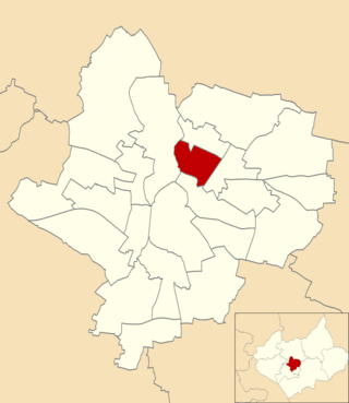
Charnwood was an electoral ward and administrative division of the city of Leicester, England. The population of the ward at the 2011 census was 13,291. It comprised the northern Leicester suburb of Northfields and its Tailby and Morton ex-council estates. Northfields has had a bad reputation for criminal activities. Despite being only 3 small estates it was responsible for 30% of the crime rate within the Leicester area. In response The Northfields Project was set upin order to help to combat crime and make Northfields a safer place to live. The scheme improved areas such as security fencing, lighting and public recreational spaces.
