Thurncourt

Last updated • 2 min readFrom Wikipedia, The Free Encyclopedia

52°38′17″N1°03′36″W / 52.638°N 1.060°W / 52.638; -1.060

Contents

Thurncourt
LeicesterThurncourtWard.svg
Population10,596 (2011)
Unitary authority
Ceremonial county
Region
Country England
Sovereign state United Kingdom
Post town LEICESTER
Postcode district LE5
Dialling code 0116
Police Leicestershire
Fire Leicestershire
Ambulance East Midlands
UK Parliament
List of places
UK
England
Leicestershire

Thurncourt is an electoral ward and administrative division of the city of Leicester, England. The population of the ward at the 2011 census was 10,596. [1] It comprises the suburb and housing estate of Thurnby Lodge in eastern Leicester.

Geography

Thurncourt is bounded by the wards of Evington to the south, and Humberstone & Hamilton to the north. [2] Roughly, it consists of the area inside the city boundary which is north of the Uppingham Road, east of the A563 outer ringroad, and south of the Scraptoft Lane.

The area south of the main shops on Thurncourt Road, towards the parallel railway embankment, was originally mainly unlandscaped country land with a natural stream running through it. The stream divides at a point opposite Thurncourt Road shops into two further tributaries, one which continues on towards the city and the other taking a route southwards under tunnels beneath the railway embankment. This natural area was extensively landscaped in several phases by the Leicester City Council and a floodplain added up until the present day, destroying a natural fertile habitat for the then common water voles and small fresh water fish found within the habitat.

It is near but not part of Thurnby (to the south-east), after which it is named. Other nearby places are Humberstone (north and west), Scraptoft (east), Evington (south) and Goodwood, Leicestershire (south).

History

Thurnby Lodge is a council estate built from the early 1950s onwards to facilitate the central Leicester slum clearance until the 1960s. The area west of Bowhill Grove was the last phase of the estate stretching to Nursery Road at its most westerly point. Two, three and four-bedroomed council houses were built in brick and concrete block, terraced with large rear and smaller front gardens.

Many of the houses on the estate have transferred to private ownership under the right to buy, resulting in a large variety of upgrades and extensions to the original council properties.

Amenities and facilities

The popular public houses are the Stirrup Cup on Thurncourt Road and at its northerly point the White House Inn on Scraptoft Lane which is part of the Whetherspoons group, serving breakfast, lunch, and dinner.

Education

There are 2 primary schools on the estate. Thurnby Mead and Willowbrook Mead, both of which are run by Rushy Mead Academy.

Transport

The estate was serviced by Midland Red buses, routes L37 and L38 whose terminus were on Thurncourt Road opposite the shops.

Buses that currently serve the area are: Arriva Midlands services 53 and 56/56a, First Leicester services 38/38a and Centrebus services 40 (Orbital)

Politics

Thurncourt (2)
PartyCandidateVotes%±%
Conservative John Allen1,49427%
Conservative Caroline Scuplak1,21922%
Labour Rikki Thomas77114%
Labour Gary Nicolle-Anderiesz73013%
BNP Clive Potter54810%
Independent Maurice Williams2635%
Green Janet Elisita2134%
Green Murray Frankland1743%
UKIP Margaret Green1132%
UKIP Stephen Ingall1092%
Turnout 3,112
Conservative hold Swing

Related Research Articles

<span class="mw-page-title-main">Evington</span> Human settlement in England

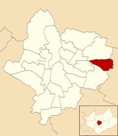
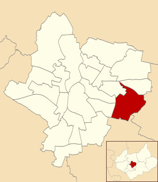
Evington is an area of Leicester, and electoral ward of the Leicester district, in the ceremonial county of Leicestershire, England. It used to be a small village centred on Main Street and the Anglican church of St Denys but was close enough to Leicester to become one of the outer suburbs in the 1930s. Today, the ward comprises the historical village of Evington, as well as the modern ex-council estates of Rowlatts Hill and Goodwood. The population of the ward at the 2011 census was 11,133.

<span class="mw-page-title-main">A47 road</span> Road in England

The A47 is a major trunk road in England linking Birmingham to Lowestoft, Suffolk, maintained and operated by National Highways. Most of the section between Birmingham and Nuneaton is now classified as the B4114. From Peterborough eastwards, it is a trunk road.

<span class="mw-page-title-main">Harborough District</span> Non-metropolitan district in England

Harborough is a local government district in Leicestershire, England. It is named after its main town, Market Harborough, which is where the council is based. The district also includes the town of Lutterworth and numerous villages and surrounding rural areas. In the north of the district it includes parts of the Leicester Urban Area, notably at Thurnby, Bushby and Scraptoft. Covering 230 square miles (600 km2), the district is the largest by area of the eight districts in Leicestershire and covers almost a quarter of the county.

<span class="mw-page-title-main">Stoneygate</span>

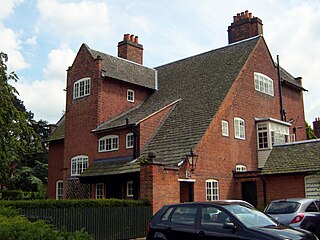
Stoneygate is part of the City of Leicester, England.

<span class="mw-page-title-main">Leicester East (UK Parliament constituency)</span> Parliamentary constituency in the United Kingdom, 1974 onwards

Leicester East is a constituency represented in the House of Commons of the UK Parliament since December 2019 by Claudia Webbe, who was elected as a Labour MP, but now sits as an Independent due to her suspension and subsequent expulsion from the party in November 2021 after she was convicted of harassment.

<span class="mw-page-title-main">Scraptoft</span> Human settlement in England

Scraptoft is a village in Leicestershire, England. It has a population of about 1,500, measured at the 2011 census as 1,804. It lies north of the A47 road east of Leicester, and runs directly into the built up area of Thurnby and Bushby to the south. For local government the village forms part of the district of Harborough, and constitutes a civil parish.

<span class="mw-page-title-main">Thurnby</span> Human settlement in England

Thurnby is a village and former civil parish, now in the parish of Thurnby and Bushby, in the Harborough district, in the county of Leicestershire, England. It is just east of Leicester's city boundaries.

Rowlatts Hill is an eastern, residential suburb of the English city of Leicester. It contains mostly council-owned housing.

Thurnby Lodge is an estate in eastern Leicester, Leicestershire, England. Roughly, it consists of the area inside the city boundary which is north of the Uppingham Road, east of the A563 outer ringroad, and south of the Scraptoft Lane. Since the core area around Thurncourt Road is a council estate with a negative reputation, many, particular those around the western and southern fringe, would disassociate their area from Thurnby Lodge.

<span class="mw-page-title-main">North Evington</span> Human settlement in England

North Evington is an area, suburb, electoral ward and administrative division of the city of Leicester, England.

Billesdon was a rural district of Leicestershire, England. It originated with the Billesdon Poor Law Union, formed in 1835. In 1894 the area became a rural district. It was named for the village of Billesdon.

<span class="mw-page-title-main">Rushey Mead</span> Suburb of Leicester, England

Rushey Mead is an area, suburb, electoral ward and administrative division of the city of Leicester, England. The population of the ward at the 2011 census was 15,962. It comprises the northern Leicester suburb of Rushey Mead in its entirety, as well as a part of the neighbouring area, suburb and electoral ward of Belgrave and historical parts of neighbouring Northfields and Thurmaston.

<span class="mw-page-title-main">Humberstone and Hamilton</span> Electoral ward and administrative division of Leicester, England

Humberstone and Hamilton is an electoral ward and administrative division of the City of Leicester, England. It comprises the north-eastern Leicester suburbs of Humberstone, Humberstone Garden City, Hamilton and Netherhall.

<span class="mw-page-title-main">Charnwood (ward)</span> Human settlement in England

Charnwood was an electoral ward and administrative division of the city of Leicester, England. The population of the ward at the 2011 census was 13,291. It comprised the northern Leicester suburb of Northfields and its Tailby and Morton ex-council estates. Northfields has had a bad reputation for criminal activities. Despite being only 3 small estates it was responsible for 30% of the crime rate within the Leicester area. In response The Northfields Project was set upin order to help to combat crime and make Northfields a safer place to live. The scheme improved areas such as security fencing, lighting and public recreational spaces.

<span class="mw-page-title-main">Coleman, Leicester</span> Human settlement in England

Coleman was an electoral ward and administrative division of the city of Leicester, England, consisting of the Leicester suburbs of Crown Hills and North Evington. It was replaced by North Evington ward in 2015.

<span class="mw-page-title-main">Humberstone Park LNR</span> Park in United Kingdom

Humberstone Park LNR is a 2.4 hectare Local Nature Reserve in Leicester. It is owned and managed by Leicester City Council.

<span class="mw-page-title-main">2019 Leicester City Council election</span>

The 2019 Leicester City Council election took place on 2 May 2019 to elect all fifty-four members of the Leicester City Council in England. This was on the same day as other local elections, and the election for the directly elected Mayor of Leicester.

References

  1. "City of Leicester ward population 2011". Neighbourhood Statistics. Office for National Statistics. Retrieved 5 June 2016.
  2. Leicester City Council. "Ward Maps" . Retrieved 11 October 2011.