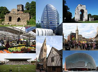
Leicester is a city and unitary authority area in the East Midlands of England, and the county town of Leicestershire. The city lies on the River Soar and close to the eastern end of the National Forest. It is to the north-east of Birmingham and Coventry, south of Nottingham, and west of Peterborough.
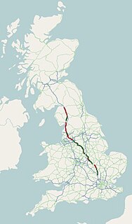
The A6 is one of the main historic north–south roads in England. It runs from Luton in Bedfordshire to Carlisle in Cumbria, although it formerly started at a junction with the A1 at Barnet. It is the fourth longest numbered road in Britain; only the A1, A38 and A30 are longer.

Oadby and Wigston is a local government district and borough in the English county of Leicestershire. It was formed in 1974, under the Local Government Act 1972, from the merger of the Oadby and Wigston urban districts. The population of the district at the 2011 census was 56,170. The district forms part of the Harborough constituency.

Wigston, or Wigston Magna, is a town in Leicestershire, England, just south of Leicester on the A5199. Wigston had a population of 32,321 in 2011.

Knighton is a residential suburban area of Leicester, situated between Clarendon Park to the north, Stoneygate to the east, Oadby and Wigston to the south and the Saffron Lane estate to the west.
Stoneygate is part of the City of Leicester, England.

Leicester South is a constituency, recreated in 1974, represented in the House of Commons of the UK Parliament since 2011 by Jon Ashworth of the Labour Co-op Party. A previous version of the seat existed between 1918 and 1950. Except for a 2004 by-election when it was won by the Liberal Democrats, Leicester South has been held by the Labour Party since 1987.
Coleshill is a market town in the North Warwickshire district of Warwickshire, England, taking its name from the River Cole, on which it stands. It had a population of 6,481 in the 2011 census and is situated 10.0 miles (16.1 km) East of Birmingham and 10.4 miles (16.7 km) North West of Coventry.

The A5199 road is the direct road from Northampton to Leicester in England. It was formerly part of the A50 trunk road that ran from Bedfordshire to Lancashire. For most of its length it is known as the Welford Road, except for small stretches near Welford where it is known as High Street and Northampton Road.

Overbrook is a neighborhood northwest of West Philadelphia, Philadelphia, in the U.S. state of Pennsylvania. The area's housing ranges from large, old homes to rowhouses to 3- and 4-story apartment buildings.

The A594 Central Ring is the name of Leicester's central distributor road network.

The A563 is the designation for the ring road of Leicester, England. It forms a near complete circuit except for a gap of around 2.2 miles (3.5 km) in the east of the city. An indirect route linking the gap involves the (A47) A6030, and A6. The A563 was formerly referred to as the Outer Ring.

Clarendon Park is an area in the south of the city of Leicester. It is bordered by Welford Road to the west, London Road to the east, Victoria Park to the north and Avenue Road/Avenue Road Extension to the south. It is part of Castle Ward and the constituency of Leicester South. There are two major shopping streets; Queens Road and Clarendon Park Road. These two roads intersect near the centre of Clarendon Park, with Queens Road running north–south, and Clarendon Park Road running east–west.

Leicester City Council is a unitary authority responsible for local government in the city of Leicester, England. It consists of 54 councillors, representing 22 wards in the city, overseen by a directly elected mayor. It is currently controlled by the Labour Party and has been led by Mayor Sir Peter Soulsby since his election on 6 May 2011. The main council building is City Hall on Charles Street, but council meetings are held in the 19th-century Town Hall.

Don Valley Village is a neighbourhood in the city of Toronto, Ontario, Canada. It is located in the former suburb of North York. It is located north of Highway 401, and is bounded by Sheppard Avenue to the south, Leslie Street to the west, Finch Avenue to the north and Highway 404 to the east. Like the nearby Don River Valley, the neighbourhood has hill and dale topography.
The A607 is an A road in England that starts in Leicester and heads northeastwards through Leicestershire and the town of Grantham, Lincolnshire, terminating at Bracebridge Heath, a village on the outskirts of Lincoln. It is a primary route from Thurmaston to the A1 junction at Grantham.
Lancaster Academy is a mixed Academy (School) for pupils aged 11 to 16, located in Knighton, Leicester, England.

Thurncourt is an electoral ward and administrative division of the city of Leicester, England. The population of the ward at the 2011 census was 10,596. It comprises the suburb and housing estate of Thurnby Lodge in eastern Leicester.

Coleman is an electoral ward and administrative division of the city of Leicester, England, consisting of the Leicester suburbs of Crown Hills and North Evington.