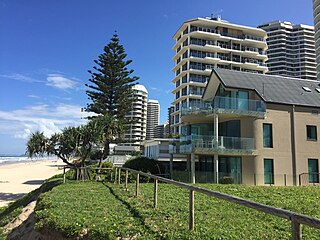
Main Beach is an affluent beachside suburb on the Gold Coast in Queensland, Australia. At the 2016 census, Main Beach had a population of 3,883.
Queensland is the second-largest and third-most populous state in the Commonwealth of Australia. Situated in the north-east of the country, it is bordered by the Northern Territory, South Australia and New South Wales to the west, south-west and south respectively. To the east, Queensland is bordered by the Coral Sea and Pacific Ocean. To its north is the Torres Strait, with Papua New Guinea located less than 200 km across it from the mainland. The state is the world's sixth-largest sub-national entity, with an area of 1,852,642 square kilometres (715,309 sq mi).
The Queensland Heritage Register is a heritage register, a statutory list of places in Queensland, Australia that are protected by Queensland legislation, the Queensland Heritage Act 1992. The register is maintained by the Queensland Heritage Council.
Cable Park is a small reserve located on the corner of Cable Street and Main Beach Parade at Main Beach on the Gold Coast. The reserve contains a small brick hut and a raised circular platform with a plaque. The brick hut is the Australian terminal of the Pacific Cable, completed in 1902. This telegraph cable linked Australia and Great Britain via Canada and British dependencies in the Pacific. It was an important communications link between the east coast of Australia and the rest of the world until its closure in 1962.[1]
The Gold Coast is a coastal city in the Australian state of Queensland, approximately 66 kilometres (41 mi) south-southeast of the state capital Brisbane and immediately north of the border with New South Wales. With a census-estimated 2016 population of 638,090, the Gold Coast is the sixth-largest city in Australia, making it the largest non-capital city, and Queensland's second-largest city.
Telegraph communication developed in the mid-19th century as a result of many years of discovery and experimentation in electrical communication culminating in the work of Samuel Morse. The rapid long distance communication provided by telegraph systems had a major impact on society. The telegraph was quickly utilised by news services; Associated Press and Reuters press service were founded to take advantage of the technology. Telegraph companies soon offered financial services, providing the facility to send money orders via the telegraph.[1]
Samuel Finley Breese Morse, OIC was an American painter and inventor. After having established his reputation as a portrait painter, in his middle age Morse contributed to the invention of a single-wire telegraph system based on European telegraphs. He was a co-developer of the Morse code and helped to develop the commercial use of telegraphy.
The Associated Press (AP) is a U.S.-based not-for-profit news agency headquartered in New York City. Founded in 1846, it operates as a cooperative, unincorporated association. The AP is owned by its contributing newspapers and radio and television stations in the United States, all of which contribute stories to the AP and use material written by its staff journalists. Its Statement of News Values and Principles spells out its standards and practices.
Reuters is an international news organization. It is a division of Thomson Reuters and has nearly 200 locations around the world. Until 2008, the Reuters news agency formed part of an independent company, Reuters Group plc, which was also a provider of financial market data. Since the acquisition of Reuters Group by the Thomson Corporation in 2008, the Reuters news agency has been a part of Thomson Reuters, making up the media division. Reuters transmits news in English, French, German, Italian, Spanish, Portuguese, Russian, Urdu, Arabic, Japanese, Korean, and Chinese. It was established in 1851.
In Australia the telegraph helped to alleviate the isolation of the colonies. New South Wales, Victoria and South Australia were connected by telegraph by 1860. Queensland's first telegraph connection was made in 1861 between Brisbane and Ipswich. Brisbane was linked to Sydney the same year.[1]
New South Wales is a state on the east coast of Australia. It borders Queensland to the north, Victoria to the south, and South Australia to the west. Its coast borders the Tasman Sea to the east. The Australian Capital Territory is an enclave within the state. New South Wales' state capital is Sydney, which is also Australia's most populous city. In March 2018, the population of New South Wales was over 7.9 million, making it Australia's most populous state. Just under two-thirds of the state's population, 5.1 million, live in the Greater Sydney area. Inhabitants of New South Wales are referred to as New South Welshmen.
Victoria is a state in south-eastern Australia. Victoria is Australia's most densely populated state and its second-most populous state overall. Most of its population lives concentrated in the area surrounding Port Phillip Bay, which includes the metropolitan area of its state capital and largest city, Melbourne, Australia's second-largest city. Geographically the smallest state on the Australian mainland, Victoria is bordered by Bass Strait and Tasmania to the south, New South Wales to the north, the Tasman Sea to the east, and South Australia to the west.
South Australia is a state in the southern central part of Australia. It covers some of the most arid parts of the country. With a total land area of 983,482 square kilometres (379,725 sq mi), it is the fourth-largest of Australia's states and territories by area, and fifth largest by population. It has a total of 1.7 million people, and its population is the second most highly centralised in Australia, after Western Australia, with more than 77 percent of South Australians living in the capital, Adelaide, or its environs. Other population centres in the state are relatively small; Mount Gambier, the second largest centre, has a population of less than 30,000.
The first telegraph link between Australia and Britain opened in 1872. The link was via the Eastern Cable Company's network. It was routed through Singapore, India, Suez and Gibraltar. It was initially proposed to make landfall in north Queensland. However, the South Australian government successfully negotiated for the link to connect with Adelaide via Port Darwin and an overland route through the centre of Australia.[1]
Singapore, officially the Republic of Singapore, is an island city-state in Southeast Asia. It lies one degree north of the equator, at the southern tip of the Malay Peninsula, with Indonesia's Riau Islands to the south and Peninsular Malaysia to the north. Singapore's territory consists of one main island along with 62 other islets. Since independence, extensive land reclamation has increased its total size by 23%. The country is known for its transition from a developing to a developed one in a single generation under the leadership of its founder Lee Kuan Yew.
India, also known as the Republic of India, is a country in South Asia. It is the seventh largest country by area and with more than 1.3 billion people, it is the second most populous country and the most populous democracy in the world. Bounded by the Indian Ocean on the south, the Arabian Sea on the southwest, and the Bay of Bengal on the southeast, it shares land borders with Pakistan to the west; China, Nepal, and Bhutan to the northeast; and Bangladesh and Myanmar to the east. In the Indian Ocean, India is in the vicinity of Sri Lanka and the Maldives, while its Andaman and Nicobar Islands share a maritime border with Thailand and Indonesia.
Suez is a seaport city in north-eastern Egypt, located on the north coast of the Gulf of Suez, near the southern terminus of the Suez Canal, having the same boundaries as Suez governorate. It has three harbours, Adabya, Ain Sukhna and Port Tawfiq, and extensive port facilities. Together they form a metropolitan area. Railway lines and highways connect the city with Cairo, Port Said, and Ismailia. Suez has a petrochemical plant, and its oil refineries have pipelines carrying the finished product to Cairo, in the flag of the governorate: the blue background refer to the sea, the gear refer to the fact that Suez an industrial governorate, and the flame refer to the petroleum firms in it.
Before the Pacific Cable was opened, the Eastern Cable Company and its associates maintained a monopoly over international telegraph traffic with Australia. As a result, the cost of communication between Britain and Australia remained very high and beyond the means of most people.[1]
Sandford Fleming, Chief Engineer of the Canadian Pacific Railway, was an early advocate of an alternative cable route between Australia and Great Britain via Canada and the Pacific Ocean. He expressed his views as early as the Colonial Conference of 1887. A major advantage put forward by Fleming and other proponents of the Pacific route was that it would be more secure in times of war. The existing link passed through countries that were not part of the British Empire. It was proposed that the Pacific Cable would pass only through British dependencies.[1]
The high cost of telegrams through the Eastern Cable Company's system provided further motivation for a competing route. The proposed Pacific Cable would break the Eastern Cable Company's monopoly and lower the cost of communication between Britain and Australia. When the Pacific Cable opened, the cost of telegrams reduced to less than half the former rate. The ability to communicate directly with the United States and so access more trade opportunities was another argument in favour of the Pacific Cable.[1]
By the mid-1890s, agreement was reached that the cable should be laid. However debate about management of the cable laying project and ownership of the completed cable continued for some years. Finally, it was agreed that funding should be shared between the governments of Britain, Canada, New Zealand and Australia. A committee named the Pacific Cable Board was formed made up of members from each of these countries. The Pacific Cable Act (1901) gave this board responsibility for managing the project and operating the completed cable.[1]
The route selected for the cable linked Southport, Norfolk Island, Fiji, Fanning Island, and Vancouver. A branch connected to New Zealand. Since cartographers of the day traditionally coloured member countries of the British Empire in red, the route became known as the All Red Route.[1]
Cable laying started in 1902 with two ships, Anglica and Colonia. Colonia, built specifically for the project, laid cable from Vancouver Island to Fanning Island in the mid-Pacific. Anglia laid cable from Southport to Norfolk Island, Fiji, New Zealand and Fanning Island.[1]
The cable was landed at Southport in March 1902. It was laid into a trench through the dunes of Narrow Neck near Southport and terminated at a cable hut located close to the beach. From here, it connected to a cable which crossed under the Nerang River to the cable station at Bauer Street. The laying of the Pacific Cable was a major engineering feat for the time, costing about two million pounds.[1]
The Pacific Cable was completed on 31 October 1902 and officially opened at Southport on 3 November 1902 by the Postmaster-General of Australia, the Honourable James Drake. It was opened to public traffic on 8 December 1902.[1]
Until 1912 Southport handled telegraph traffic for all over Australia. In 1912, a cable from Auckland was extended to Sydney and for a period after this, traffic for the southern States went directly to Sydney from Auckland. Technical changes to the system in 1923, including the installation of automatic repeaters, relegated Southport to a repeater station.[1]
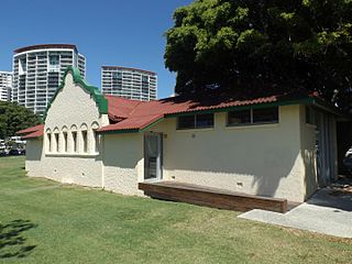
By January 1950, the original cable hut located close to the beach at Narrow Neck had gone, leaving only a cement slab and a flag pole partly surrounded by a barbed wire fence. It is believed that it was destroyed in a severe storm. Serious erosion of the cable reserve by February 1951 threatened these remains and the cable connections located there. The current brick hut located at Cable Park was built during the first half of 1951 to remedy this situation.[1]
In October 1962, the Compac Cable between Sydney and Vancouver was completed. The original Pacific Cable was thus rendered redundant and the Southport to Norfolk Island cable was closed. The Cable Station at Bauer Street was sold to De La Salle Brothers who operated a community youth centre there. In the early 1980s, the Cable Station buildings were removed, two of them to The Southport School where they continue to function as music rooms. However, the brick cable hut remains in its original location at Cable Park, Southport.[1]
Description
Plaque adjacent to hut, 2015
Cable Park is a small grassy reserve located on Main Beach Parade at Main Beach at the Gold Coast. The Cable Hut is a small brick structure set well back from Main Beach Parade in the park.[1]
The hut is about 2.4 metres (7ft 10in) square in plan view and about 2.7 metres (8ft 10in) high. There no windows, airflow being provided by ventilator bricks. It has a flat concrete roof. A plain wooden door, secured by a barrel bolt and padlock, is centered in the northern wall. A section of submarine cable is mounted on the eastern wall above a rectangular brass plaque.[1]
The interior of the hut is unlined and has a wooden floor. The pine skirting boards are of recent construction. Fastened to the wall opposite the door are three groups of cables passing through the floor. These cables run vertically up the wall and are held in place by a long wooden beam extending the length of the wall. The beam is fastened to the brickwork by bolts.[1]
The group at the eastern end of the wall comprises two thick black cables. The outer insulating material of each cable has been removed to a length of about one metre from the end. An inner armoured sheath has been folded back over the outer insulation to expose another layer of insulation. This has been removed to expose three insulated wires. The wires are fixed to the wall on a block of wood.[1]
At the opposite end of the wall is a group of three cables. The insulation and sheathing on one of these cables has been removed in a similar way to the cables mentioned previously. However, only a short length of insulation has been removed from the other two cables.[1]
The third group of cables comprises two grey cables, one considerably thinner than the other. These pass through the floor between the two outer groups about an equal distance from each. The larger of the two cables is fixed with a metal saddle to a rectangular piece of wood fastened to the wall. Just above this, the cable enters a red, rectangular metal box bolted to the wall.[1]
About fourteen smaller grey cables emerge from the top of this box; they are fixed to the wall by a bracket. Above this, twelve of the cables turn and run horizontally to the east, over two rusted metal brackets. Six of the cables are draped over these brackets and hang towards the floor. The other six run further to the left to a point immediately above the two thick cables at the eastern end of the wall. At this point, they turn towards the floor meeting the two cables coming up from the floor. They are fastened to the wall on a block of wood.[1]
Immediately to the west of the red metal box is a wooden panel fixed to the wall. Mounted on this is a large, brass pressure gauge. The thinner of the two grey cables which emerge from the floor is fitted into the bottom of this gauge. Two of the cables which come out of the top of the red metal box turn to the west and curve downwards around the bottom of the wooden panel to enter the gauge at approximately the 'two o'clock' position.[1]
A paved path runs from the eastern side of the hut towards a large raised circular platform. This has an aggregate top and set into this is a round metal plaque. Depicted on the plaque is a map of the world showing the route of the Pacific Cable.[1]
Shrubs and palm trees grow in a small garden bed around the hut. A garden bed of shrubbery runs along the southern and western border of the park.[1]
Heritage listing
The former Southport Cable Hut was listed on the Queensland Heritage Register on 3 May 2007 having satisfied the following criteria.[1]
The place is important in demonstrating the evolution or pattern of Queensland's history.
The Southport Cable Hut (c.1951) is important in demonstrating the evolution of Queensland's history insofar that it marks the Australian terminal of the Pacific Cable, Australia's second telegraph link with Great Britain and the first to be government owned. Known as the All Red Route, the Pacific Cable was also the first link between Australia and Britain to pass only through countries of the British empire, by convention coloured red on world maps. The opening of the Pacific Cable in 1902 was an important step forward in international communications for Australia since it resulted in faster, more secure and much more affordable communications between Britain and Australia.[1]
The place demonstrates rare, uncommon or endangered aspects of Queensland's cultural heritage.
The Cable Hut is the only surviving structure associated with the Southport terminal of the Pacific Cable that remains in its original location. Buildings of the former, nearby Cable Station, where communications were received and sent through the Pacific Cable, are extant but have been moved from their original location to the Southport School.[1]
The place is important in demonstrating the principal characteristics of a particular class of cultural places.
The place is important in demonstrating the principal characteristics of cable huts; small buildings where submarine telegraph cables were linked to their terrestrial counterparts. The Southport cable hut is a small, functional structure of simple, robust design. Fastened to the rear wall inside the hut are the ends of the Pacific Cable, the cable link to Sydney and the link to the Cable Station formerly located at Bauer Street, Southport. A gauge and equipment for maintaining gas pressure in the cable to Bauer Street also remain extant in the hut.[1]
Related Research Articles
Cairns is a city in the Cairns Region, Queensland, Australia. It is on the east coast of Far North Queensland. The city is the 5th-most-populous in Queensland and ranks 14th overall in Australia.
The All Red Line was an informal name for the system of electrical telegraphs that linked much of the British Empire. It was inaugurated on 31 October 1902. The name derives from the common practice of colouring the territory of the British Empire red or pink on political maps.
The Gold Coast railway line is an interurban railway line operated by Queensland Rail in Queensland, Australia, connecting Brisbane with the Gold Coast.
Burleigh Heads is a suburb in the City of Gold Coast in Queensland, Australia. At the 2011 Census, Burleigh Heads had a population of 9,188.
Southport is a suburb and the central business district near the midpoint of Gold Coast, Queensland, Australia and has one of the city's largest communities. As of the 2016 Census, Southport had a population of 31,908.
Johann Heinrich Casper Meyer (??-1901) was a German immigrant to Queensland and a pioneer of the Gold Coast region.
Nobby is a small town and locality on the Darling Downs in the Toowoomba Region, Queensland, Australia. It is located halfway between Toowoomba and Warwick. In the 2011 census, Nobby had a population of 484 people.
The history of the Gold Coast in Queensland, Australia began in prehistoric times with archaeological evidence revealing occupation of the district by Australian Aborigines for at least 23,000 years. The first early European colonizers began arriving in the late 1700s, settlement soon followed throughout the 19th century, and by 1959 the town was proclaimed a city. Today, the Gold Coast is one of the fastest growing cities in Australia.
The South Coast railway line was an Australian railway from Brisbane, the capital city of Queensland, to the Gold Coast. It operated from 1889 to 1964. The Gold Coast railway line re-opened in 1996 along a modified alignment in the north and a new route south.
Australia was a relatively early adopter of telegraph technology in the middle nineteenth century, despite its low population densities and the difficult conditions sometimes encountered in laying lines. From 1858 onwards, the major capitals were progressively linked, culminating in the addition of Perth in 1877. Australia was linked to the rest of the world for the first time in 1872, through the Overland Telegraph which ran some 3200 km from Adelaide through to Darwin. The network continued to expand in size and sophistication until 1959 and in heavy usage until 1945, after which time telephone usage began to erode public patronage of telegraphy services. The final publicly provided telegraphy service was closed in 1993.
Southport Pier is a pier spanning the Gold Coast Broadwater in Southport, a suburb on the Gold Coast in South East Queensland, Australia. The current pier was constructed in 2009, replacing a previous structure demolished in 1969.
Fort Cowan Cowan is a heritage-listed World War II fortification at 30 Jessie Wadsworth Street, Moreton Island, City of Brisbane, Queensland, Australia. It is also known as RAN 3 Cowan Cowan, Fort Cowan and Cowan Cowan Battery. It was added to the Queensland Heritage Register on 1 October 2007.
Main Beach Pavilion and Southport Surf Lifesaving Club are heritage-listed beach buildings off Macarthur Parade, Main Beach, Queensland, Australia. The Main Beach Pavilion was designed by Thomas Ramsay Hall and Lionel Blythewood Phillips of the architectural firm Hall and Phillips and built in 1934 for the Southport Town Council. The Surf Lifesaving Club was also designed by Hall and Phillips and built adjacent in 1936 for the club. They were added to the Queensland Heritage Register on 1 March 1995.
Southport Bathing Pavilion is a heritage-listed changing rooms at Marine Parade, Southport, Gold Coast City, Queensland, Australia. It was designed by Hall & Phillips and built in 1934 by A. Ledbury. It was added to the Queensland Heritage Register on 13 January 1995.
Wallangarra railway station is a heritage-listed railway station at Woodlawn Street, Wallangarra, Southern Downs Region, Queensland, Australia. It was built in 1877 along the state border of Queensland and New South Wales It was added to the Queensland Heritage Register on 28 March 2003.
The Hotel Cecil is an Art Deco hotel located on the south western corner of the intersection of Scarborough and Nerang Streets in Southport, Queensland, Australia. It has been recommended that it be added to the Queensland Heritage Register due to its rarity, high architectural value and contribution to the character of the street.
Coen Carrier Station is a heritage-listed telegraph station at Coleman Close, Coen, Shire of Cook, Queensland, Australia. It was designed and built in 1942 by the Postmaster-General's Department. It is also known as Coen Telegraph Station and Coen Carrier Repeater Station. It was added to the Queensland Heritage Register on 27 May 1997.
Thomas Ramsay Hall was an architect practicing in Brisbane, Australia, during the first half of the twentieth century and was involved in the design and construction of numerous major buildings in South East Queensland including the Queensland Heritage Register listed Brisbane City Hall.
This page is based on this Wikipedia article Text is available under the CC BY-SA 4.0 license; additional terms may apply. Images, videos and audio are available under their respective licenses.