Special routes of U.S. Route 21

Last updated
US 21.svg
U.S. Route 21
Highway system

Several special routes of U.S. Route 21 exist. In order from south to north they are as follows.

Contents

Existing

Beaufort business loop

Business plate.svg

US 21.svg

U.S. Highway 21 Business

Location Beaufort, South Carolina
Length5.400 mi [1] (8.690 km)
Existed1967–present

U.S. Route 21 Business (US 21 Bus.) is a 5.400-mile (8.690 km) business route in Beaufort that travels along Sea Island Parkway, Carteret Street, and Boundary Street. [2]

Orangeburg business loop 2

Business plate.svg

US 21.svg

U.S. Highway 21 Business

Location Orangeburg, South Carolina
Length2.730 mi [3] (4.394 km)
Existed1967[ citation needed ]–present

U.S. Route 21 Business (US 21 Bus.) is a 2.730-mile (4.394 km) business route of US 21. It begins at the intersection of US 21 and SC 4 and then traverses along parts of Charleston Highway and Magnolia Street, before ending at Chestnut Street (US 21). [4]

Orangeburg connector route

Connector plate.svg

US 21.svg

U.S. Highway 21 Connector

Location Orangeburg, South Carolina
Length1.480 mi [5] (2.382 km)

U.S. Route 21 Connector (US 21 Conn.) is a 1.480-mile (2.382 km) connector route of US 21 that is unsigned. It travels from Broughton Street (US 178 Bus.) to Chestnut Street (US 21/US 178), via Park Street and Columbia Road. [6] [7]

West Columbia connector route

Connector plate.svg

US 21.svg

U.S. Highway 21 Connector

Location West Columbia, South Carolina
Length0.850 mi [8] (1.368 km)

U.S. Route 21 Connector (US 21 Conn.) is a 0.850-mile (1.368 km) connector route of US 21 that exists entirely within the city limits of West Columbia. It connects US 21/US 176/US 321, from where they curve off of Charleston Highway and onto Knox Abbott Drive, with US 1. [9] It shares the Charleston Highway name with US 21/US 176/US 321 and is an unsigned highway. [10]

The entire route is in West Columbia, Lexington County.

mi [8] kmDestinationsNotes
0.0000.000US 21.svgUS 176.svgUS 321.svg US 21 / US 176 / US 321 (Charleston Highway south / Knox Abbott Drive east)Southern terminus; US 21 Conn. and US 21/US 176/US 321 share the Charleston Highway name.
0.4200.676South Carolina 602.svg SC 602 west (D Avenue) / 13th Street north Lexington Eastern terminus of SC 602; southern terminus of 13th Street.
0.6301.01412th Street (SC 35)
0.8501.368 US 1 northNo access from US 21 Conn. to US 1 south or from US 1 north to US 21 Conn.
1.000 mi = 1.609 km; 1.000 km = 0.621 mi

Columbia connector route

Connector plate.svg

US 21.svg

U.S. Highway 21 Connector

Location Columbia, South Carolina
Length2.930 mi [11] (4.715 km)

U.S. Route 21 Connector (US 21 Conn.) is a 2.930-mile-long (4.715 km) connector route of US 21 that is an unsigned highway. It is located in the west-central part of Richland County and entirely within the city limits of Columbia in the U.S. state of South Carolina. It connects US 21/US 176/US 321 with US 76/US 378. It is concurrent with US 76 Conn. for its entire length.

It begins at an intersection with US 21/US 176/US 321 (Blossom Street/Huger Street). It travels to the east-northeast on Blossom Street. It crosses over some railroad tracks of CSX. It passes Greek Village, the fraternities and sororities of the University of South Carolina (USC). Right after passing the Carolina Coliseum, it intersects South Carolina Highway 48 (SC 48; Assembly Street). The highway passes the Carolina Community Garden at the Honors Residence Hall. Then, it passes the Thomas Cooper Library and then the Booker T. Washington Auditorium. It curves to the northeast and travels along the northwestern edge of Maxcy Gregg Park. This is southeast of the USC tennis courts at Blossom Street. The connector curves to the east and travels under a railroad bridge that carries railroad tracks of Norfolk Southern Railway. It curves to the southeast. At the intersection with Saluda Avenue, the highway turns left and travels to the northeast. One block later, at Devine Street, it turns right and travels to the east-northeast. At an intersection with Harden Street, it curves to the east-southeast and travels through a retail area before meeting its northern terminus, an intersection with US 76/US 378 (Millwood Avenue/Devine Street). [12] [13]

The entire route is in Columbia, Richland County.

mi [11] kmDestinationsNotes
0.0000.000US 21.svgUS 176.svgUS 321.svg US 21 / US 176 / US 321 (Blossom Street/Huger Street)Southern terminus; south end of unsigned western segment of US 76 Conn. concurrency
0.5800.933South Carolina 48.svg SC 48 (Assembly Street)
2.9304.715US 76.svgUS 378.svg US 76 / US 378 (Millwood Avenue/Devine Street)Northern terminus; north end of unsigned western segment of US 76 Conn. concurrency
1.000 mi = 1.609 km; 1.000 km = 0.621 mi

Ridgeway connector route

Connector plate.svg

US 21.svg

U.S. Highway 21 Connector

Location Ridgeway, South Carolina
Length1.660 mi [14] (2.672 km)

U.S. Route 21 Connector (US 21 Conn.) is a connector route that partially travels through the western part of Ridgeway, which is in the southeastern part of Fairfield County. It is known as Coleman Highway and is an unsigned highway. [15] It begins at an intersection with US 21 just southeast of Ridgeway. It travels to the northwest and enters the town. It then curves to the west-northwest before leaving the city limits. Then, it curves to the west before reaching its northern terminus, an intersection with South Carolina Highway 34 (SC 34). [16]

Fort Mill business loop

Business plate.svg

US 21.svg

U.S. Highway 21 Business

Location Fort Mill, South Carolina
Length7.060 mi [17] (11.362 km)
Existed1948[ citation needed ]–present

U.S. Route 21 Business (US 21 Bus.) traverses through downtown Fort Mill, via Spratt Street, White Street, Old Nation Road, and Springfield Parkway. [18]

Elkin business loop

Business plate.svg

US 21.svg

U.S. Highway 21 Business

Location Jonesville-Elkin, North Carolina
Length7.8 mi [19] (12.6 km)
Existed1966–present

U.S. Route 21 Business (US 21 Bus.) traverses through downtown Jonesville and Elkin, via Main Street and Bridge Street. The route was established after the mainline was realigned east along a completed section of I-77.

Sparta truck route

Truck plate.svg

US 21.svg

U.S. Highway 21 Truck

Location Sparta, North Carolina
Length1.68 mi [20] (2.70 km)
Existed2020–present

U.S. Route 21 Truck (US 21 Truck) is an alternate route for trucks to bypass the downtown central business district and allows truck traffic to travel on and off of NC 18. The 1.68-mile (2.70 km) route follows along the Sparta Parkway, which bypasses west from mainline US 21, connecting with Grandview Drive and West Whitehead Street (NC 18). [21]

Former

Orangeburg business loop 1

Business plate.svg

US 21.svg

U.S. Highway 21 Business

Location Orangeburg, South Carolina
Length3.3 mi (5.3 km)
Existed1950–1967

U.S. Route 21 Business (US 21 Bus.) originally traversed along Broughton Street (in concurrency with US 178 Bus), Park Street, and Columbia Road. In 1967, the business loop was decommissioned after the establishment of the second business loop through Orangeburg; the old alignment continues as US 178 Bus (Broughton Street) and US 21 Conn (Park Street and Columbia Street).

Rock Hill business loop

Business plate.svg

US 21.svg

U.S. Highway 21 Business

Location Rock Hill, South Carolina
Length6.7 mi [22] (10.8 km)
Existed1950–2013

U.S. Route 21 Business (US 21 Bus.) originally traversed along Main Street, Albright Road, Black Street, Oakland Avenue, and Cherry Road, through downtown Rock Hill. It was decommissioned at the request of Rock Hill to gain ownership and maintenance oversight from the state. [23] [24]

Bluefield bypass route

By-pass plate.svg

US 21.svg

U.S. Route 21 Bypass

Location Bluefield, West Virginia

U.S. Route 21 Business (US 21 Bus.) originally traveled through downtown Bluefield utilizing Bluefield Avenue and Princeton Avenue, but as U.S. Route 21 no longer serves north of Wytheville, Virginia, there is not a U.S. Route 21 Business. Prior to the Interstate Highway system, US 21 ran from Ohio to Florida. Once Interstate 77 was built, there was no longer a need for US 21 and it made its terminus Wytheville, Virginia.

See also

Related Research Articles

U.S. Route 176 is a spur of US 76 in the U.S. states of North Carolina and South Carolina. The U.S. Highway runs 237.98 miles (382.99 km) from US 25 Business and North Carolina Highway 225 in Hendersonville, North Carolina, east to US 52 in Goose Creek, South Carolina. US 176 serves the transition region between the Blue Ridge Mountains and Foothills of Western North Carolina and the Upstate, Midlands, and Lowcountry regions of South Carolina. The highway passes through and connects Spartanburg, one of two major cities in the Upstate, and Columbia, the South Carolina state capital and central city of the Midlands. US 176 parallels and serves as a secondary highway to Interstate 26 (I-26) except for between Spartanburg and Columbia, where the U.S. Highway deviates from the I-26 corridor to serve Union.

U.S. Route 378 is a spur of US 78 in the U.S. states of Georgia and South Carolina. The U.S. Highway runs 234.30 miles (377.07 km) from US 78, Georgia State Route 10, SR 17, and SR 47 in Washington, Georgia, east to US 501 Business in Conway, South Carolina. US 378 connects the Central Savannah River Area in both states with the Midlands and Pee Dee regions of South Carolina. The U.S. Highway's western portion, which connects Washington and Lincolnton in Georgia and McCormick, Saluda, and Lexington in South Carolina, is mainly a rural highway. US 378 is a major suburban and urban highway through Lexington and the South Carolina state capital, Columbia. The highway has a lengthy concurrency with US 76 between Columbia and Sumter and serves as a major route between the Midlands and the Myrtle Beach area, between which the highway has a business route through Lake City.

U.S. Route 178

U.S. Highway 178 is a spur of U.S. Highway 78. It currently runs for 240.49 miles (387.03 km) from Dorchester, South Carolina, at U.S. Highway 78 to Rosman, North Carolina, at U.S. Highway 64. It passes through the states of South Carolina and North Carolina. It goes through the cities of Pickens, Anderson, North, Orangeburg, Harleyville, South Carolina and Bowman, South Carolina.

South Carolina Highway 160

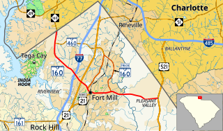
South Carolina Highway 160 (SC 160) is a 11.040-mile (17.767 km) primary state highway in the U.S. state of South Carolina. It travels from North Carolina state line, through Fort Mill, ending in Indian Land.

South Carolina Highway 9

South Carolina Highway 9 (SC 9) is a 259.570-mile (418 km) major state highway in the U.S. state of South Carolina. The highway travels from Cherry Grove Beach to the North Carolina state line upstate. The highway is currently the longest state highway in South Carolina. It is signed as a north–south highway, even though it travels in an east–west direction.

South Carolina Highway 6

South Carolina Highway 6 (SC 6) is a 116.092-mile (186.832 km) state highway in the U.S. state of South Carolina. It extends from US 76 in Ballentine to US 52/SC 6 Truck in Moncks Corner. It uniquely links all three of the major hydropower projects in South Carolina: Lake Murray, Lake Marion, and Lake Moultrie.

South Carolina Highway 34

South Carolina Highway 34 (SC 34) is a 185.930-mile (299.225 km) primary state highway in the U.S. state of South Carolina. As one of the longer state highways, it traverses the state east-west from Greenwood to Dillon, connecting the cities of Newberry, Winnsboro, Camden, Bishopville and Darlington.

South Carolina Highway 90

South Carolina Highway 90 (SC 90) is a 23.110-mile (37.192 km) state highway in Horry County, within the northeastern part of the U.S. state of South Carolina. It travels from Red Hill to Little River. It provides a direct connection from Conway to the northern Grand Strand in Little River.

Several special routes of U.S. Route 1 exist, from Florida to Maine. In order from south to north, separated by type, these special routes are as follows.

U.S. Route 76 in South Carolina

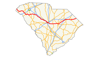
U.S. Route 76 (US 76) is an east–west U.S. highway in the U.S. state of South Carolina. Being one of the longest highways in the state, it connects the cities of Anderson, Columbia, Sumter and Florence.

Seven special routes of U.S. Route 278 currently exist. Three of them lie within the state of Arkansas. One more existed in the past but has since been decommissioned.

South Carolina Highway 385

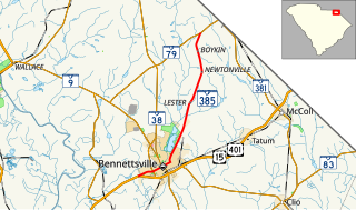
South Carolina Highway 385 (SC 385) is a 11.730-mile (18.878 km) primary state highway in the U.S. state of South Carolina. It connects the city of Bennettsville with northern Marlboro County.

South Carolina Highway 4

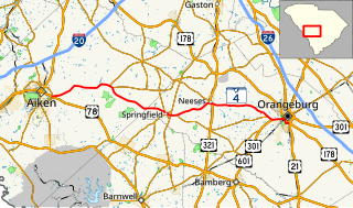
South Carolina Highway 4 (SC 4) is a 54.430-mile-long (87.597 km) state highway in the southern part of the U.S. state of South Carolina. The highway connects Aiken and Orangeburg, via Springfield and Neeses.

Several special routes of U.S. Route 15 exist. In order from south to north they are as follows.

Several special routes of U.S. Route 25 exist. In order from south to north they are as follows.

South Carolina Highway 20

South Carolina Highway 20 (SC 20) is a primary state highway in the U.S. state of South Carolina. The highway connects the cities of Abbeville, Belton, Williamston and Greenville. The 53-mile-long (85 km) highway is signed as a west-east highway though it physically runs south-to-north.

South Carolina Highway 23

South Carolina Highway 23 (SC 23) is a 47.060-mile (75.736 km) primary state highway in the U.S. state of South Carolina. It serves to connect Edgefield and Batesburg-Leesville with Columbia via U.S. Route 1 (US 1).

South Carolina Highway 97

South Carolina Highway 97 (SC 97) is a 89.800-mile (144.519 km) state highway in the U.S. state of South Carolina. The highway connects Camden, Great Falls, Chester, and Hickory Grove.

South Carolina Highway 252

South Carolina Highway 252 (SC 252) is a 35.711-mile-long (57.471 km) state highway in the U.S. state of South Carolina. The highway connects the Anderson and Laurens areas with Honea Path and Ware Shoals. It has a unique feature in that it intersects U.S. Route 76 (US 76) three times along its length.

Four special routes of U.S. Route 521 exist, and two others have existed in the past. In order from south to north they are as follows.

References

  1. "Highway Logmile Report". South Carolina Department of Transportation. Retrieved December 7, 2020.
  2. Google (February 2, 2011). "Overview map of US 21 Bus. (Beaufort)" (Map). Google Maps . Google. Retrieved February 2, 2011.
  3. "Highway Logmile Report" . Retrieved December 7, 2020.
  4. Google (December 7, 2020). "Overview map of US 21 Bus. (Orangeburg 2)" (Map). Google Maps . Google. Retrieved December 7, 2020.
  5. "Highway Logmile Report". South Carolina Department of Transportation. Retrieved December 7, 2020.
  6. Functional Classification Map for City of Orangeburg (PDF) (Map). South Carolina Department of Transportation. July 11, 2012. Retrieved July 8, 2013.
  7. Google (July 8, 2013). "Overview map of US 21 Conn. (Orangeburg)" (Map). Google Maps . Google. Retrieved July 8, 2013.
  8. 1 2 "Highway Logmile Report". South Carolina Department of Transportation. Retrieved December 28, 2020.
  9. Google (December 29, 2020). "Overview map of US 21 Conn. (West Columbia)" (Map). Google Maps. Google. Retrieved December 29, 2020.
  10. Columbia Urban Area (PDF) (Map). August 2020. p. Sheet 19. § J12. Retrieved December 29, 2020.
  11. 1 2 "Highway Logmile Report". South Carolina Department of Transportation. Retrieved December 7, 2020.
  12. Columbia City (PDF) (Map). South Carolina Department of Transportation . Retrieved January 25, 2017.
  13. Google (January 25, 2017). "Overview map of US 21 Conn." (Map). Google Maps . Google. Retrieved January 25, 2017.
  14. "Highway Logmile Report". South Carolina Department of Transportation. Retrieved December 7, 2020.
  15. Columbia Urban Area (PDF) (Map). South Carolina Department of Transportation. August 2020. p. Sheet 1. § A15. Retrieved December 7, 2020.
  16. Google (December 7, 2020). "Overview map of US 21 Conn. (Ridgeway)" (Map). Google Maps. Google. Retrieved December 7, 2020.
  17. "Highway Logmile Report". South Carolina Department of Transportation. Retrieved December 7, 2020.
  18. Google (February 2, 2011). "Overview map of US 21 Bus. (Fort Mill)" (Map). Google Maps. Google. Retrieved February 2, 2011.
  19. Google (February 2, 2011). "US 21 Business - Elkin" (Map). Google Maps. Google. Retrieved February 2, 2011.
  20. Google (July 22, 2020). "US 21 Truck - Sparta" (Map). Google Maps. Google. Retrieved July 22, 2020.
  21. "NC Route Change (2020-06-25)" (PDF). Raleigh, North Carolina: North Carolina Department of Transportation. June 25, 2020. Retrieved July 22, 2020.
  22. Google (February 2, 2011). "US 21 Business - Rock Hill" (Map). Google Maps. Google. Retrieved February 2, 2011.
  23. "Binder-all applications May 2013" (PDF). AASHTO. May 2013. p. 301. Archived from the original (PDF) on October 19, 2013. Retrieved July 7, 2013.
  24. "Report to SCOH from USRN SM2013 May 3" (PDF). AASHTO. May 3, 2013. p. 8. Retrieved July 7, 2013.