 Special routes of U.S. Route 22 | |
|---|---|
| Highway system | |
At least eight special routes of U.S. Route 22 (US 22) have existed and at least six have been deleted.
| Special routes of U.S. Route 22 | |
|---|---|
| Highway system | |
At least eight special routes of U.S. Route 22 (US 22) have existed and at least six have been deleted.
| | This section is empty. You can help by adding to it. (December 2013) |
U.S. Route 22 Temporary | |
|---|---|
| Location | Green Tree–Pittsburgh, Pennsylvania |
| | This section is empty. You can help by adding to it. (December 2013) |
U.S. Route 22 Truck | |
|---|---|
| Location | Pittsburgh, Pennsylvania |
U.S. Route 22 Business | |
|---|---|
| Location | Monroeville, Pennsylvania |
| Length | 5 mi (8.0 km) |

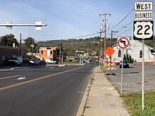
U.S. Route 22 Business (US 22 Bus.) is a five-mile (8.0 km) loop through the eastern Pittsburgh suburbs of Churchill, Wilkins Township, and Monroeville, Pennsylvania, on William Penn Highway. The route's western terminus is at a freeway junction with Interstate 376 (I-376), which features a concurrency by the business loop's parent route. The route was the former pathway of US 22 itself before the construction that extended I-376 from this point eastward to the Pennsylvania Turnpike, in the early 1960s. The first two miles (3.2 km) of the road are contained in a valley, surrounded by a variety of side roads leading to suburban, mostly residential development. The remaining three miles (4.8 km) feature dense commercial development, including several office high rises and Monroeville Mall. The highway ends at a complicated junction that features the northern terminus of Pennsylvania Route 48 (PA 48), the southern end of Haymaker Road, and I-376, which features its last two exits (before the Pennsylvania Turnpike) with the above streets. US 22 Bus. then travels for its final eighth of a mile (0.201 km) on a viaduct that allows for connections with the Pennsylvania Turnpike and a smooth transition on to US 22 east (continuing William Penn Highway) toward suburban Murrysville.
Major intersections
The entire route is in Allegheny County.
{{PAint
| Location | mi | km | Destinations | Notes | |
|---|---|---|---|---|---|
| Churchill | 0.00 | 0.00 | Western terminus; exit 80 on I-376 | ||
| 0.19 | 0.31 | Western end of Yellow Belt concurrency; southern terminus of PA 791 | |||
| 0.87 | 1.40 | Interchange; eastern end of Yellow Belt concurrency | |||
| Wilkins Township | 2.17 | 3.5 | Kingston Drive | Entrance to Eastmont | |
| Monroeville | 2.49 | 4.01 | Monroeville Mall | Interchange | |
| 4.14 | 6.66 | Northern terminus of PA 48; exit 84A on I-376 | |||
| Eastbound exit and westbound entrance; exit 57 on I-76 / Turnpike | |||||
| 4.38 | 7.05 | Eastern terminus | |||
1.000 mi = 1.609 km; 1.000 km = 0.621 mi
| |||||
U.S. Route 22 Business | |
|---|---|
| Location | Lewistown, Pennsylvania |
| Length | 5 mi (8.0 km) |
U.S. Route 22 Business (US 22 Bus.) is a five-mile (8.0 km) loop through Lewistown, Pennsylvania. It serves as the major through street, taking on the former designation of its parent, which has become a freeway bypass. The first two miles (3.2 km) of the route travel through rural Granville Township. The middle two-mile (3.2 km) segment is lined with small development and features several stoplights and a segment that contains a center turning lane. The last two miles (3.2 km) wind along the Juniata River toward the eastern freeway juncture in Derry Township.
Major intersections
The entire route is in Mifflin County.
| Location | mi | km | Destinations | Notes | |
|---|---|---|---|---|---|
| Granville Township | 0.00 | 0.00 | Interchange | ||
| Lewistown | 2.98 | 4.80 | Northern terminus of PA 103 | ||
| 3.41 | 5.49 | Eastbound exit and westbound entrance | |||
| Derry Township | 5.02 | 8.08 | Interchange; access to eastbound US 22/US 322 and from westbound US 22/US 322 | ||
| 1.000 mi = 1.609 km; 1.000 km = 0.621 mi | |||||
U.S. Route 22 Bypass | |
|---|---|
| Location | Harrisburg, Pennsylvania |
| Existed | 1930s–1978 |
U.S. Route 22 Bypass (US 22 Byp.) was a bypass of the routing of US 22 through downtown Harrisburg, Pennsylvania, from the 1930s to 1978. The bypass began at US 22/US 322 (Front Street/2nd Street) along the Susquehanna River and headed east on Maclay Street. Upon intersecting PA 230 (Cameron Street), US 22 Byp. ran southeast on Arsenal Boulevard and east on Herr Street before it reached its eastern terminus at US 22 (Walnut Street) near Penbrook. [1] US 22 Byp. was first designated by 1940 between US 22 and US 230 at the intersection of Cameron and Maclay streets in Harrisburg and US 22 near Penbrook, following Arsenal Boulevard and Herr Street. [2] In the 1940s, US 22 Byp. was extended west along Maclay Street to end at US 22/US 322/PA 14 (Front Street), running concurrent with US 230. [3] In the 1950s, the route east of US 230 became concurrent with US 230 Byp. [4] The US 230 and US 230 Byp. concurrencies were removed during the 1960s. [1] On June 29, 1978, the American Association of State Highway and Transportation Officials (AASHTO) approved the removal of the US 22 Byp. designation; the route was replaced by US 22 along Arsenal Boulevard and Herr Street. [5] [6]
Major intersections
The entire route was in Dauphin County.
| Location | mi | km | Destinations | Notes | |
|---|---|---|---|---|---|
| Harrisburg | 0.000 | 0.000 | |||
| 0.064 | 0.103 | ||||
| 1.040 | 1.674 | ||||
| Penbrook | 3.150 | 5.069 | Mileage from Google Maps. | ||
| 1.000 mi = 1.609 km; 1.000 km = 0.621 mi | |||||
U.S. Route 22 Alternate | |
|---|---|
| Location | Bethlehem–Easton, Pennsylvania |
| Existed | 1930s–1950s |
U.S. Route 22 Alternate (US 22 Alt.) was an alternate route of US 22 that ran between the cities of Bethlehem and Easton in Pennsylvania between the 1930s and 1950s. The alternate route began at US 22 and PA 12 at the intersection of Main and Union streets in downtown Bethlehem, heading east on Union Street. The route briefly turned north along Linden Street before it headed east on Goepp Street, which became Pembroke Road as it left Bethlehem. US 22 Alt. became Freemansburg Avenue and passed through Freemansburg. The route continued east to Wilson, where it came to its eastern terminus at US 22 (Butler Street). [3] [7] US 22 Alt. was first designated in the 1930s, beginning at US 22 and PA 12 at the intersection of Main and Goepp streets in Bethlehem and following Goepp Street, Pembroke Road, and Freemansburg Avenue to US 22 at Butler Street in Wilson. [2] [8] In the 1940s, US 22 Alt. was shifted to use Union Street to intersect US 22 and PA 12 in Bethlehem. [3] The US 22 Alt. designation was decommissioned during the 1950s. [4] [9]
Major intersections
The entire route was in Northampton County.
| Location | mi | km | Destinations | Notes | |
|---|---|---|---|---|---|
| Bethlehem | |||||
| Wilson | |||||
| 1.000 mi = 1.609 km; 1.000 km = 0.621 mi | |||||
U.S. Route 22 Alternate | |
|---|---|
| Location | Phillipsburg, New Jersey |
U.S. Route 22 Alternate (US 22 Alt.) was an alternate route of US 22 located in Phillipsburg, New Jersey. The route began at the Northampton Street Bridge over the Delaware River to Easton, Pennsylvania. From here, the alternate route followed South Main Street through Phillipsburg. US 22 Alt. headed into Pohatcong Township and became New Brunswick Avenue. Here, the route formed a short concurrency with County Route 519 (CR 519) and continued east to its eastern terminus at US 22. [10] US 22 Alt. was first designated in the 1940s to run along the former alignment of US 22 through Easton and Phillipsburg that was bypassed. The alternate route began at US 22 at the intersection of 7th and Northampton streets in Easton and ran east along Northampton Street to the Northampton Street Bridge into New Jersey. At this point, US 22 Alt. became concurrent with Route 28 and ran through Phillipsburg on South Main Street and Pohatcong Township on New Brunswick Avenue before ending at US 22. [2] In the 1953 New Jersey state highway renumbering, the concurrent Route 28 designation in New Jersey was removed. [11] [12] During the 1950s, the western terminus of US 22 Alt. was moved to the Northampton Street Bridge, with PA 45 replacing the route along Northampton Street in Easton. [4] On October 23, 1993, AASHTO approved the removal of the US 22 Alt. designation. [13] The route was replaced by CR 678 and Route 122. [10]
Major intersections
| County | Location | mi | km | Destinations | Notes |
|---|---|---|---|---|---|
| Northampton | Easton | Northampton Street west | Pennsylvania state line | ||
| Delaware River | Northampton Street Bridge | ||||
| Warren | Pohatcong Township | Western terminus of CR 519 overlap | |||
| Eastern terminus of CR 519 overlap | |||||
| 1.000 mi = 1.609 km; 1.000 km = 0.621 mi | |||||
U.S. Route 22 Bypass | |
|---|---|
| Location | Easton, Pennsylvania–Phillipsburg, New Jersey |
| Existed | 1930s–1940s |
U.S. Route 22 Bypass (US 22 Byp.) was the designation for a bypass of the segment of US 22 through the downtown areas of Easton, Pennsylvania, and Phillipsburg, New Jersey, between the 1930s and 1940s. The bypass began at US 22 (Northampton Street) in Easton and headed northeast on Prospect Avenue, Pearl Street, and Bushkill Street, intersecting US 611 (3rd Street). The route crossed the Delaware River on the Easton–Phillipsburg Toll Bridge into New Jersey, where it ran east concurrent with Route 24 on Morris Street. US 22 Byp. turned southeast along Route 24-28 Link to end at US 22/Route 28 in Pohatcong Township. The bypass route was designated in the 1930s. [2] [8] In the 1940s, US 22 Byp. was replaced with mainline US 22, with the former alignment of US 22 through Easton and Phillipsburg becoming US 22 Alt. [3] [7]
Major intersections
| County | Location | mi | km | Destinations | Notes |
|---|---|---|---|---|---|
| Northampton | Easton | ||||
| Delaware River | Easton–Phillipsburg Toll Bridge | ||||
| Warren | Phillipsburg | Western terminus of Route 24 overlap | |||
| Lopatcong Township | Eastern terminus of Route 24 overlap, western terminus of Route 24-28 Link overlap | ||||
| Pohatcong Township | Eastern terminus of Route 24-28 Link overlap | ||||
| 1.000 mi = 1.609 km; 1.000 km = 0.621 mi | |||||

U.S. Route 22 (US 22) is a major east–west route and one of the original United States Numbered Highways, founded in 1926. It runs from Cincinnati, Ohio, at US 27, US 42, US 127, and US 52 to Newark, New Jersey, at US 1/9 at the Newark Airport Interchange.

Route 122 is a short, 2.42-mile-long (3.89 km) state highway in Warren County, New Jersey. The route runs from Warren County Route 678 and Pursel Street in Phillipsburg to an intersection with U.S. Route 22 (US 22) in Pohatcong Township. The route is a former alignment of US 22, designated in 1926, however, until 1993, the route was designated U.S. Route 22 Alternate. After 1993, the route was decommissioned and replaced by County Route 678 (CR 648) and Route 122.
Pennsylvania Route 309 is a state highway that runs for 134 miles (216 km) through eastern Pennsylvania. The route runs from an interchange between PA 611 and Cheltenham Avenue on the border of Philadelphia and Cheltenham Township north to an intersection with PA 29 in Bowman Creek, a village in Monroe Township in Wyoming County. The highway connects Philadelphia and its northern suburbs to Allentown and the Lehigh Valley, and Hazleton and Wilkes-Barre in Wyoming Valley.

Pennsylvania Route 248 is a 31.3 mi (50.4 km) long state highway in the eastern part of the U.S. state of Pennsylvania. The western terminus of the route is at U.S. Route 209 in Weissport East, a CDP in Franklin Township. The eastern terminus is at PA 611 in Easton. The route begins at US 209 in Carbon County and heads southeast parallel to the Lehigh River as a four-lane divided highway to Bowmanstown, where it becomes a freeway and heads through Palmerton. Upon crossing Lehigh Gap in Blue Mountain, PA 248 enters Northampton County and becomes a two-lane undivided highway that heads southeast through rural areas, serving Bath and Nazareth. From here, the route runs southeast through suburban areas to Wilson, where it turns east and follows city streets through Easton.

Pennsylvania Route 329 is a Pennsylvania state highway that runs for 12.9 miles (20.8 km) through Lehigh and Northampton counties in the Lehigh Valley region of the state. It runs from PA 873 in the North Whitehall Township village of Neffs east to PA 248 and PA 987 in Bath. The route is a two-lane undivided road that runs through a mix of rural and developed areas to the north of the cities of Allentown and Bethlehem, serving the communities of Balliettsville, Egypt, Cementon, and Northampton. PA 329 intersects PA 145 near Egypt and runs concurrent with PA 987 between East Allen Township and the eastern terminus in Bath.

Pennsylvania Route 191 is a 111.54 mi (179.51 km)-long state highway in the U.S. state of Pennsylvania. The route, a major non-freeway corridor connecting the Lehigh Valley to the Pocono Mountains in eastern Pennsylvania, is designated from U.S. Route 22 in Brodhead near Bethlehem to the New York state line over the Delaware River at Hancock, New York.

Pennsylvania Route 611 is a state highway in eastern Pennsylvania running 109.7 mi (176.5 km) from Interstate 95 (I-95) in the southern part of Philadelphia north to I-380 in Coolbaugh Township in the Pocono Mountains.

Pennsylvania Route 313 is a mostly 2-lane, 18-mile-long (29 km) state highway entirely within Bucks County, Pennsylvania. The western end of PA 313 is at an intersection with PA 309 and PA 663 in Quakertown. The eastern end is at an intersection with PA 263 in the Doylestown Township community of Furlong. PA 313 is signed an east–west road, although it runs almost purely northwest–southeast through most of its course. It is a major arterial road in central and northern Bucks County as it connects several communities including Quakertown, Dublin, and Doylestown.
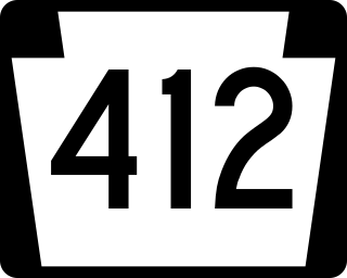
Pennsylvania Route 412 is a 17.75-mile-long (28.57 km) north–south state route located in Bucks and Northampton counties in southeastern Pennsylvania. Its southern terminus is at PA 611 in the Nockamixon Township community of Harrow. Its northern terminus is at PA 378 in Bethlehem.

Pennsylvania Route 66 (PA 66) is a 139.7-mile-long (224.8 km) state highway in Western Pennsylvania. Its southern terminus is at U.S. Route 119 near Interstate 70 (I-70) near New Stanton. Its northern terminus is at US 6 in Kane.
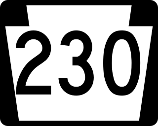
Pennsylvania Route 230 is a 28.4-mile (45.7 km) long state route in central Pennsylvania. Its western terminus is at an intersection with U.S. Route 22 in Harrisburg. Its eastern terminus is at an interchange with PA 283 near Salunga. The route passes northwest-southeast through Dauphin and Lancaster counties and serves as a surface road parallel to the PA 283 freeway that connects the cities of Harrisburg and Lancaster. Along the way, PA 230 passes through Middletown, Elizabethtown, and Mount Joy. The route intersects the Airport Connector near the Harrisburg International Airport, PA 441 and PA 341 in the Middletown area, PA 241 and PA 743 in Elizabethtown, and PA 772 in Mount Joy.
Interstate 78 (I-78) is a major east–west Interstate Highway stretching from Union Township, Lebanon County, Pennsylvania, in the west to the Holland Tunnel and New York City in the east. In Pennsylvania, I-78 runs for about 78 miles (126 km) from the western terminus at I-81 in Union Township east to the New Jersey state line near Easton in Northampton County.

Several special routes of U.S. Route 1 (US 1) exist, from Florida to Maine. In order from south to north, separated by type, these special routes are as follows.

U.S. Route 13 (US 13) runs along the Atlantic coastline for over 500 miles (800 km), passing through five states. Along its route, it possessed numerous special routes, which are all loops off the mainline US 13. At present, there are at least 15 special routes in existence: two in North Carolina, five in Virginia, two in Maryland, four in Delaware, and two in Pennsylvania. 13 others have existed in the past but have been deleted.
U.S. Route 22 (US 22) is a United States Numbered Highway stretching from Cincinnati, Ohio, in the west to Newark, New Jersey, in the east. In New Jersey, the route runs for 60.53 miles (97.41 km) from the Easton–Phillipsburg Toll Bridge over the Delaware River in Phillipsburg, Warren County, to Interstate 78 (I-78), US 1/9, and Route 21 at the Newark Airport Interchange in Newark, Essex County. The road first heads through the Phillipsburg–Alpha area as an arterial road before running concurrent with I-78 through mountainous and agricultural sections of western New Jersey between Alpha and east of Clinton in Hunterdon County. For the remainder of the route, US 22 runs to the south of I-78 through mostly suburban areas as a four- to six-lane arterial road, passing through Hunterdon, Somerset, Union, and Essex counties. Along this portion, it intersects US 202 and US 206 in Somerville, I-287 in Bridgewater Township, and the Garden State Parkway in Union.

A total of at least five special routes of U.S. Route 322 currently exist.

Several special routes of U.S. Route 30 exist. In order from west to east they are as follows.

Several special routes of U.S. Route 19 (US 19) exist. In order from south to north, they are as follows.

At least 17 special routes of U.S. Route 11 (US 11) and at least one of US 11E have existed.

At least four special routes of U.S. Route 422 currently exist and at least three have been decommissioned.