Wilkins Township, Pennsylvania

Last updated
Wilkins Township
Beaver Avenue in Wilkins Township.jpg
Houses on Beaver Avenue
Allegheny County Pennsylvania incorporated and unincorporated areas Wilkins township highlighted.svg
Location in Allegheny County and state of Pennsylvania
Coordinates: 40°25′22″N79°49′25″W / 40.42278°N 79.82361°W / 40.42278; -79.82361
Country United States
State Pennsylvania
County Allegheny
Incorporated10 November 1821
Government
  Council PresidentSylvia Martinelli (D)
Area
[1]
  Total2.75 sq mi (7.11 km2)
  Land2.75 sq mi (7.11 km2)
  Water0.00 sq mi (0.00 km2)
Population
 (2010)
  Total6,357
  Estimate 
(2018) [2]
6,161
  Density2,273.59/sq mi (877.89/km2)
Time zone UTC-5 (Eastern (EST))
  Summer (DST) UTC-4 (EDT)
ZIP Codes
15145, 15235
FIPS code 42-003-85184

Wilkins Township is a township in Allegheny County, Pennsylvania, United States. The population was 6,357 at the 2010 census. [3] It is served by Pennsylvania's 12th congressional district, the 43rd District of the Pennsylvania State Senate, and the 34th District of the Pennsylvania State House of Representatives.

Contents

Wilkins Township was named for William Wilkins (1779–1865), a politician from Pennsylvania who served in both houses of Congress and as U.S. Secretary of War. [4]

History

The township was created from the eastern part of Pitt Township on November 10, 1821. Its territory originally stretched between the Allegheny and Monongahela rivers; from it sprang most of the municipalities between Pittsburgh on the west and Plum and Monroeville on the east. [5]

Geography

Wilkins Township is located at 40°25′21″N79°49′24″W / 40.42250°N 79.82333°W / 40.42250; -79.82333 (40.422668, -79.823491). [6] According to the United States Census Bureau, the township has a total area of 2.6 square miles (6.8 km2), all land.

Watershed

The southeastern border of the township is denoted by Thompson Run, a tributary of Turtle Creek. The township is drained by Thompson Run and its tributaries Sawmill Run and Chalfant Run, which in turn has a tributary, Lougeay Run, which flows into the township from Penn Hills. The entire township lies within the Turtle Creek Watershed.

Transportation

Interstate 376 passes through the northern limb of the township, where it has an exit just as it enters eastbound from Churchill Borough, number 81 onto PA 791/Rodi Road/Yellow Belt northbound into Penn Hills. The business spur of U.S. Route 22 enters eastbound from Churchill, and is where the main commercial section of Wilkins township is located, including the Penn Center East shopping center. US Business 22 crosses Thompson Run from Wilkins Township to Monroeville over the Hall Station Bridge. PA 130 serves the southern portion of the township. The Union Railroad, following the Thompson Run valley, passes through the eastern fringe of the township.

Surrounding neighborhoods

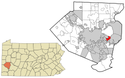
Wilkins Township has eight borders, including Penn Hills to the north, Monroeville to the east, Turtle Creek to the southeast, East Pittsburgh to the south, North Braddock to the south-southwest, Chalfant to the southwest, Forest Hills to the west and Churchill to the northwest and north-northwest.

Demographics

Historical population
CensusPop.Note
1970 8,749
1980 8,472−3.2%
1990 7,585−10.5%
2000 6,917−8.8%
2010 6,357−8.1%
2018 (est.)6,161 [2] −3.1%
U.S. Decennial Census [7]

As of the census [8] of 2000, there were 6,917 people, 3,235 households, and 2,012 families residing in the township. The population density was 2,637.6 inhabitants per square mile (1,018.4/km2). There were 3,432 housing units at an average density of 1,308.7 per square mile (505.3/km2). The racial makeup of the township was 92.79% White, 4.38% African American, 0.09% Native American, 1.52% Asian, 0.06% Pacific Islander, 0.19% from other races, and 0.98% from two or more races. 0.45% of the population were Hispanic or Latino of any race.

There were 3,235 households, out of which 19.3% had children under the age of 18 living with them, 50.9% were married couples living together, 9.0% had a female householder with no husband present, and 37.8% were non-families. 33.8% of all households were made up of individuals, and 16.6% had someone living alone who was 65 years of age or older. The average household size was 2.14 and the average family size was 2.73.

In the township the population was spread out, with 16.9% under the age of 18, 5.4% from 18 to 24, 25.8% from 25 to 44, 26.1% from 45 to 64, and 25.8% who were 65 years of age or older. The median age was 46 years. For every 100 females there were 89.5 males. For every 100 females age 18 and over, there were 85.6 males.

The median income for a household in the township was $37,439, and the median income for a family was $47,882. Males had a median income of $37,127 versus $31,101 for females. The per capita income for the township was $24,515. About 3.8% of families and 6.4% of the population were below the poverty line, including 7.8% of those under age 18 and 4.3% of those age 65 or over.

Education

Wilkins Township is served by the Woodland Hills School District.

Government and politics

Presidential Elections Results [9] [10] [11]
Year Republican Democratic Third Parties
2020 34%1,39664%2,5841%44
2016 40%1,40459%2,0521%50
2012 44%1,56355%1,9631%34

Related Research Articles

<span class="mw-page-title-main">Allegheny County, Pennsylvania</span> County in Pennsylvania, United States

Allegheny County is a county in Pennsylvania, United States. It is located in Southwestern Pennsylvania. As of the 2020 census, the population was 1,250,578, making it the state's second-most populous county, after Philadelphia County. Its county seat and most populous city is Pittsburgh, Pennsylvania's second most populous city. Allegheny County is part of the Pittsburgh, PA metropolitan statistical area and the Pittsburgh media market.

<span class="mw-page-title-main">Blawnox, Pennsylvania</span> Borough in Pennsylvania, United States

Blawnox is a borough in Allegheny County, Pennsylvania, United States. The population was 1,454 at the 2020 census. It is part of the Pittsburgh metropolitan area.

<span class="mw-page-title-main">Chalfant, Pennsylvania</span> Borough in Pennsylvania, United States

Chalfant is a borough in Allegheny County, Pennsylvania, United States. The population was 748 at the 2020 census.

<span class="mw-page-title-main">Churchill, Pennsylvania</span> Borough in Pennsylvania, United States

Churchill is a borough in Allegheny County, Pennsylvania, United States. The population was 3,157 at the 2020 census. It is a residential suburb of the Pittsburgh metropolitan area. The town was named from the hilltop Beulah Presbyterian Church.

<span class="mw-page-title-main">East Pittsburgh, Pennsylvania</span> Borough in Pennsylvania, United States

East Pittsburgh is a borough in Allegheny County, Pennsylvania, United States, approximately 11 miles (18 km) southeast of the confluence of the Monongahela and the Allegheny rivers at Pittsburgh. The population in 1900 stood at 2,883, and in 1910, at 5,615. As of the 2020 census, the borough population was 1,927, having fallen from 6,079 in 1940. George Westinghouse erected large works there which supplied equipment to the great power plants at Niagara Falls and for the elevated and rapid-transit systems of New York City. Nearby, the George Westinghouse Bridge over Turtle Creek is a prominent fixture in the area, which is very near the borough of Braddock.

<span class="mw-page-title-main">Elizabeth, Pennsylvania</span> Borough in Pennsylvania, United States

Elizabeth is a borough in Allegheny County, Pennsylvania, United States, on the east bank of the Monongahela River, where Pennsylvania Route 51 crosses, 15 miles (24 km) upstream (south) of Pittsburgh and close to the county line. The population was 1,398 at the 2020 census. The borough of Elizabeth is entirely contained within the 15037 USPS ZIP code. The local school district is the Elizabeth Forward School District. The borough is home to neighborhoods Walker Heights and Town Hill. Elizabeth Borough is the birthplace of Town Hill Hockey established in 1978.

<span class="mw-page-title-main">Forest Hills, Pennsylvania</span> Borough in Pennsylvania, United States

Forest Hills is a borough in Allegheny County, Pennsylvania, United States. The population was 6,429 at the 2020 census. It is a suburb of the Pittsburgh metropolitan area. The borough was named after Forest Hills, Queens.

<span class="mw-page-title-main">Harmar Township, Allegheny County, Pennsylvania</span> Township in Pennsylvania, United States

Harmar Township is a township in Allegheny County, Pennsylvania, United States. The population was 3,136 at the 2020 census.

<span class="mw-page-title-main">Monroeville, Pennsylvania</span> Borough in Pennsylvania, United States

Monroeville is a home rule municipality in Allegheny County, Pennsylvania, United States. It is a suburb with mixed residential and commercial developments located about 10 miles (16 km) east of Pittsburgh. As of the 2020 census, Monroeville was home to 28,640 people.

<span class="mw-page-title-main">North Braddock, Pennsylvania</span> Borough in Pennsylvania, United States

North Braddock is a borough in Allegheny County, Pennsylvania, United States, along the Monongahela River. The 2020 census had the borough population at 4,320. It is a suburb 11 miles (18 km) east of Pittsburgh. Organized from a part of Braddock Township in 1897, the borough prides itself in being the "Birthplace of Steel" as the home of Andrew Carnegie's Edgar Thomson Steel Works that opened in 1875.

<span class="mw-page-title-main">Penn Hills, Pennsylvania</span> Home rule township in Pennsylvania, United States

Penn Hills is a township with home rule status in Allegheny County, Pennsylvania, United States. The population was 41,059 as of the 2020 census. A suburb of Pittsburgh, Penn Hills is the second-largest municipality in Allegheny County.

<span class="mw-page-title-main">Plum, Pennsylvania</span> Borough in Pennsylvania, United States

Plum is a borough in Allegheny County, Pennsylvania, United States. The population was 27,144 at the 2020 census. A suburb of the Pittsburgh metropolitan area, it is located northeast of the city in what is commonly referred to as the East Hills suburbs.

<span class="mw-page-title-main">Turtle Creek, Pennsylvania</span> Borough in Pennsylvania, United States

Turtle Creek is a borough in Allegheny County, Pennsylvania, United States, 12 miles (19 km) southeast of Pittsburgh. The population was 5,114 at the 2020 census. George Westinghouse constructed a manufacturing plant nearby. Turtle Creek takes its name from a small stream that flows into the Monongahela River. Before white settlers arrived, there was a small village of Native Americans living there from the Turtle Clan of the Iroquois Nation.

<span class="mw-page-title-main">Verona, Pennsylvania</span> Borough in Pennsylvania, United States

Verona is a borough in Allegheny County, Pennsylvania, United States. It is 13 miles (21 km) northeast of downtown Pittsburgh, along the left bank of the Allegheny River. As of the 2020 census, the borough had a population of 2,492.

<span class="mw-page-title-main">West Deer Township, Pennsylvania</span> Township in Pennsylvania, United States

West Deer Township is a township in Allegheny County, Pennsylvania, Pennsylvania, United States. The population was 12,262 at the 2020 census.

<span class="mw-page-title-main">Wilmerding, Pennsylvania</span> Borough in Pennsylvania, United States

Wilmerding is a borough in Allegheny County, Pennsylvania, United States. The population was 1,781 at the 2020 census. It is located 12 miles (19 km) southeast of Pittsburgh. At the start of the twentieth century, it had extensive foundries and machine shops of the Westinghouse Air Brake Company. Wilmerding is adjacent to the borough of Turtle Creek, which takes its name from a small stream that flows past both places.

<span class="mw-page-title-main">Murrysville, Pennsylvania</span> Home rule municipality in Pennsylvania, United States

Murrysville is a home rule municipality in Westmoreland County, Pennsylvania, United States. The population was 21,006 at the 2020 census. It is part of the Pittsburgh metropolitan area.

<span class="mw-page-title-main">Trafford, Pennsylvania</span> Borough in Pennsylvania, United States

Trafford is a borough in Allegheny and Westmoreland counties in the U.S. state of Pennsylvania. Located near Pittsburgh in western Pennsylvania, the borough lies primarily in Westmoreland County; only a small portion extends into Allegheny County. It was incorporated in 1904 from the northernmost corner of North Huntingdon Township, and was named by George Westinghouse for Trafford near Manchester, England. Westinghouse purchased the land in 1902, and the Trafford Foundry began operations on October 3, 1903. The population was 3,317 at the 2020 census. Of this, 3,113 were in Westmoreland County, and only 61 were in Allegheny County.

<span class="mw-page-title-main">Harrison Township, Allegheny County, Pennsylvania</span> Township in Pennsylvania, United States

Harrison Township is a township in Allegheny County in the U.S. state of Pennsylvania. The population was 10,169 at the 2020 census. Pennsylvania Route 28 passes through Harrison Township, connecting Kittanning to the northeast and Pittsburgh to the southwest. Allegheny Technologies has extensive steel mill facilities in Harrison Township, including its Allegheny Ludlum Brackenridge Works. Harrison Township is located at the far northeast corner of Allegheny County. Its northern border is the Butler County line and the Allegheny River forms the township's eastern boundary with Westmoreland County. Its northeast corner also touches Armstrong County.

<span class="mw-page-title-main">Shaler Township, Pennsylvania</span> Township in Pennsylvania, United States

Shaler Township is a township in Allegheny County in the U.S. state of Pennsylvania. It consists of much of the community of Glenshaw and several neighboring communities. The population was 28,757 at the 2010 census. It is part of the Pittsburgh metropolitan area.

References

  1. "2016 U.S. Gazetteer Files". United States Census Bureau. Retrieved Aug 13, 2017.
  2. 1 2 Bureau, U. S. Census. "U.S. Census website". United States Census Bureau . US Census Bureau. Retrieved 1 December 2019.
  3. "Race, Hispanic or Latino, Age, and Housing Occupancy: 2010 Census Redistricting Data (Public Law 94-171) Summary File (QT-PL), Wilkins township, Allegheny County, Pennsylvania". United States Census Bureau . Retrieved September 30, 2011.
  4. Porter, Thomas J. Jr. (May 10, 1984). "Town names carry a little bit of history". Pittsburgh Post-Gazette. p. 1. Retrieved 26 May 2015.
  5. "Wilkins Township History" (PDF). Wilkins Township. Retrieved 26 February 2018.
  6. "US Gazetteer files: 2010, 2000, and 1990". United States Census Bureau. 2011-02-12. Retrieved 2011-04-23.
  7. "Census of Population and Housing". Census.gov. Retrieved June 4, 2016.
  8. "U.S. Census website". United States Census Bureau . Retrieved 2008-01-31.
  9. EL. "2012 Allegheny County election". Pittsburgh Tribune-Review. Retrieved 15 October 2017.
  10. EL. "2016 Pennsylvania general election..." Pittsburgh Post-Gazette. Retrieved 15 October 2017.
  11. "Election Night Reporting".