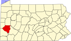
Bridgeville, Pennsylvania | |
---|---|
Etymology: Bridge over Chartiers Creek | |
Coordinates: 40°21′25″N80°06′31″W / 40.35694°N 80.10861°W | |
Country | United States |
State | Pennsylvania |
County | Allegheny |
Settled | c. 1830 |
Incorporated | July 27, 1901 |
Government | |
• Mayor | Betty Copeland (D) |
Area | |
• Total | 1.10 sq mi (2.84 km2) |
• Land | 1.09 sq mi (2.84 km2) |
• Water | 0.00 sq mi (0.00 km2) |
Elevation | 820 ft (250 m) |
Population | |
• Total | 4,804 |
• Density | 4,387.21/sq mi (1,693.68/km2) |
Time zone | UTC-5 (EST) |
• Summer (DST) | UTC-4 (EDT) |
ZIP code | 15017 |
Area code | 412 |
FIPS code | 42-08624 |
School district | Chartiers Valley |
Website | www |
Bridgeville is a borough in Allegheny County, Pennsylvania, United States. The population was 4,804 at the 2020 census. [3] It is a residential suburb of the Pittsburgh metropolitan area.
The village that eventually became Bridgeville acquired its name because of the first bridge built at the crossing of Chartiers Creek at the south end of what is now Washington Avenue. [4]
The area was originally named St. Clair Township in 1763, and the southern part was split off as Upper St. Clair Township in 1806. For nearly 100 years, Bridgeville was a village within Upper St. Clair Township, known for its one bridge over Chartiers Creek where people frequently met to trade goods. An old saying, "Meet me at the bridge," provided an obvious name for the village that began to develop north of the bridge [5] around 1830. [6]
Mining operations began in the 1880s, prompting growth. [7] Bridgeville was officially incorporated as a borough on July 27, 1901, from Upper St. Clair Township. [6]
A mass shooting took place on August 4, 2009, in an LA Fitness health club near Bridgeville in Collier Township. The attack resulted in four deaths, including that of the perpetrator, who took his own life. Nine other people were injured. [8]
Bridgeville is located along Chartiers Creek, about 8 miles (13 km) southwest of downtown Pittsburgh at 40°21′25″N80°6′31″W / 40.35694°N 80.10861°W . [9]
According to the United States Census Bureau, the borough has a total area of 1.1 square miles (2.8 km2), all land. Its average elevation is 1,250 ft (381 m) above sea level. [10]
McLaughlin Run, a tributary to Chartiers Creek, flows through Bridgeville.
Bridgeville has three borders with the townships of Collier to the north and northwest, South Fayette to the west and southwest, and Upper St. Clair to the south, southeast and east.
Census | Pop. | Note | %± |
---|---|---|---|
1880 | 147 | — | |
1910 | 1,983 | — | |
1920 | 3,092 | 55.9% | |
1930 | 3,939 | 27.4% | |
1940 | 4,459 | 13.2% | |
1950 | 5,650 | 26.7% | |
1960 | 7,112 | 25.9% | |
1970 | 6,717 | −5.6% | |
1980 | 6,154 | −8.4% | |
1990 | 5,445 | −11.5% | |
2000 | 5,341 | −1.9% | |
2010 | 5,148 | −3.6% | |
2020 | 4,804 | −6.7% | |
Sources: [11] [12] [13] [14] [15] [2] |
As of the census [14] of 2000, there were 5,341 people, 2,539 households, and 1,444 families residing in the borough. The population density was 4,938.5 people per square mile (1,906.8 people/km2). There were 2,656 housing units at an average density of 2,455.9 per square mile (948.2/km2). The racial makeup of the borough was 94.05% White, 4.42% African American, 0.09% Native American, 0.37% Asian, 0.34% from other races, and 0.73% from two or more races. Hispanic or Latino of any race were 0.77% of the population.
There were 2,539 households, out of which 20.8% had children under the age of 18 living with them, 43.6% were married couples living together, 10.1% had a female householder with no husband present, and 43.1% were non-families. 39.5% of all households were made up of individuals, and 21.4% had someone living alone who was 65 years of age or older. The average household size was 2.09 and the average family size was 2.81.
In the borough the population was spread out, with 18.0% under the age of 18, 5.6% from 18 to 24, 28.4% from 25 to 44, 22.2% from 45 to 64, and 25.8% who were 65 years of age or older. The median age was 44 years. For every 100 females, there were 86.9 males. For every 100 females age 18 and over, there were 82.3 males.
The median income for a household in the borough was $34,873, and the median income for a family was $46,500. Males had a median income of $35,461 versus $25,527 for females. The per capita income for the borough was $19,500. About 5.6% of families and 7.8% of the population were below the poverty line, including 6.6% of those under age 18 and 12.0% of those age 65 or over.
Year | Republican | Democratic | Third Parties |
---|---|---|---|
2020 | 48%1,374 | 50% 1,447 | 1% 37 |
2016 | 48%1,181 | 47% 1,155 | 5% 127 |
2012 | 50%1,149 | 49% 1,137 | 1% 24 |
Bridgeville is served by the Chartiers Valley School District. The public school serves students from Bridgeville, Collier, Scott, and Heidelberg.
Baldwin Township is a township in Allegheny County, Pennsylvania, United States. The population was 1,984 at the 2020 census, a decrease from the figure of 1,992 tabulated in 2010.
Bethel Park is a borough with home rule status in Allegheny County, Pennsylvania, United States. It is a suburb within the Pittsburgh metropolitan area, located approximately 7 miles (11 km) south of Pittsburgh. The population was 33,577 as of the 2020 census.
Carnegie is a borough in Allegheny County, Pennsylvania, United States. The population was 8,134 in the 2020 census. It is part of the Pittsburgh metropolitan area.
Collier Township is a township in Allegheny County, Pennsylvania, United States. The population was 8,931 at the 2020 census, an increase over the figure of 7,080 tabulated in 2010.
Crafton is a borough in Allegheny County, Pennsylvania, United States, west of downtown Pittsburgh. The population was 6,099 at the 2020 census. It is a residential suburb of the Pittsburgh metropolitan area.
Heidelberg is a borough located southwest of Pittsburgh in Allegheny County, Pennsylvania, United States. The population was 1,288 at the 2020 census. The borough was named after Heidelberg in Germany, the native home of a large share of the early settlers.
Jefferson Hills is a borough in Allegheny County, Pennsylvania, United States. In the 2020 census, the population was 12,424. It is part of the Pittsburgh metropolitan area.
Mount Oliver is a borough in Allegheny County, Pennsylvania, United States. The population was 3,394 at the 2020 census. It is a largely residential area situated atop a crest about 3 miles (5 km) west of the Monongahela River. The borough is surrounded entirely by the city of Pittsburgh, having resisted annexation attempts by the city.
Oakdale is a borough in Allegheny County, Pennsylvania, United States. The population was 1,475 at the 2020 census. It is a suburb of Pittsburgh.
Penn Hills is a township with home rule status in Allegheny County, Pennsylvania, United States. The population was 41,059 as of the 2020 census. A suburb of Pittsburgh, Penn Hills is the second-largest municipality in Allegheny County.
Rosslyn Farms is a suburban borough located 5 miles (8 km) west of Pittsburgh in Allegheny County, Pennsylvania, United States. It is a small community, with an area of only 0.6 square miles (1.6 km2). The population was 441 at the 2020 census.
South Fayette Township is a township in Allegheny County, Pennsylvania, United States. The population was 14,416 at the 2010 census.
Tarentum is a borough in Allegheny County in the U.S. state of Pennsylvania. It is 22 miles (35 km) northeast of Downtown Pittsburgh, along the Allegheny River. Tarentum was an industrial center where plate glass and bottles were manufactured; bricks, lumber, steel and iron novelties, steel billets and sheets, sack and wrapping paper were also produced.
Thornburg is a borough in Allegheny County in the U.S. state of Pennsylvania. The population was 466 at the 2020 census.
Turtle Creek is a borough in Allegheny County, Pennsylvania, United States, 12 miles (19 km) southeast of Pittsburgh. The population was 5,114 at the 2020 census. George Westinghouse constructed a manufacturing plant nearby. Turtle Creek takes its name from a small stream that flows into the Monongahela River. Before white settlers arrived, there was a small village of Native Americans living there from the Turtle Clan of the Iroquois Nation.
Wilmerding is a borough in Allegheny County, Pennsylvania, United States. The population was 1,781 at the 2020 census. It is located 12 miles (19 km) southeast of Pittsburgh. At the start of the twentieth century, it had extensive foundries and machine shops of the Westinghouse Air Brake Company. Wilmerding is adjacent to the borough of Turtle Creek, which takes its name from a small stream that flows past both places.
Chartiers Township is a township in Washington County, Pennsylvania, United States. The population was 8,632 at the 2020 census. Along with the borough of Houston, the township makes up the Chartiers-Houston School District. It is part of the Pittsburgh metropolitan area.
McDonald is a borough in Allegheny and Washington counties in the U.S. state of Pennsylvania, 18 miles (29 km) southwest of Pittsburgh. The population was 2,056 at the 2020 census. Of this, 1,661 were in Washington County, and 395 were in Allegheny County.
Scott Township is a township in Allegheny County, Pennsylvania, United States. The population was 17,024 at the 2010 census.
Wilkins Township is a township in Allegheny County, Pennsylvania, United States. The population was 6,357 at the 2010 census. It is served by Pennsylvania's 12th congressional district, the 43rd District of the Pennsylvania State Senate, and the 34th District of the Pennsylvania State House of Representatives.