Chartiers Creek

Last updated
Chartiers Creek
Tributary to Ohio River
Kitfry-1-.jpg
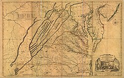
1751 map depicting Chartiers Creek (labeled as "Shartees Cr.", at top edge of map)
USA Pennsylvania relief location map.svg
Red pog.svg
Location of Chartiers Creek mouth
Usa edcp relief location map.png
Red pog.svg
Chartiers Creek (the United States)
Location
Country United States
State Pennsylvania
County Allegheny
Washington
City Washington
Borough Canonsburg
Carnegie
McKees Rocks
Thornburg
Heidelberg
Bridgeville
Houston
Physical characteristics
SourceFork of Bane Creek divide
  locationabout 0.25 miles north of Van Buren, Pennsylvania
  coordinates 40°05′05″N080°17′16″W / 40.08472°N 80.28778°W / 40.08472; -80.28778 [1]
  elevation1,220 ft (370 m) [2]
Mouth Ohio River
  location
McKees Rocks, Pennsylvania
  coordinates
40°27′54″N080°03′10″W / 40.46500°N 80.05278°W / 40.46500; -80.05278 [1]
  elevation
710 ft (220 m) [3]
Length47.60 mi (76.60 km) [4]
Basin size277.42 square miles (718.5 km2) [5]
Discharge 
  location Ohio River
  average321.31 cu ft/s (9.098 m3/s) at mouth with Ohio River [5]
Basin features
Progressiongenerally northeast [4]
River system Ohio River
Tributaries 
  left Georges Run
Chartiers Run
McPherson Creek
Coal Run
Millers Run
Thoms Run
Robinson Run
Campbells Run
  right Catfish Creek
Little Chartiers Creek
Brush Run
McLaughlin Run
Painters Run
Scrubgrass Run
Whiskey Run
WaterbodiesReservoir #2
BridgesPA 18 (x4), Farmer Lane, Old Scales Road, Vaneal Drive, Mounts Road, Jolly School Road, Old Plank Road, PA 18, Walker Lane, PA 18, Ridgewood Drive, US 40, I-70, Caldwell Avenue, Jessop Place, W Wylie Avenue, Woodland Avenue, PA 844, Wallace Lane, PA 18, Oak Grove Road, N Main Street Ext., Country Club Road, Pike Street, Racetrack Road, Vandale Drive, S. Johnson Road, S Main Street, Strabane Avenue, S. Jefferson Avenue, S Central Avenue, Morganza Road, Curry Avenue, Curry Hill Road, Southpoint Boulevard, I-79, Morganza Road, Atlas Lane, Maple Lane, Georgetown Road, Boyce Road, Mayview Road, PA 50, I-79, Prestley Road, Steen Road, I-79, PA 50, Greentree Road, Washington Avenue, Carothers Avenue, W Main Street, Chestnut Street, I-376, Rutgers Road, Stubenville Pike, Wind Gap Bridge, PA 51, W Carson Street

Chartiers Creek is a tributary of the Ohio River in Western Pennsylvania in the United States. The creek was named after Peter Chartier, [6] a trapper of French and Native American parentage who established a trading post at the mouth of the creek in 1743.

Contents

Course

Chartiers Creek winds from its headwaters in Washington County through Allegheny County, where it meets the Ohio River at McKees Rocks and Pittsburgh's West End, three miles west of the Point at Pittsburgh.

Tributaries

(Mouth at the Ohio River)

Environmental issues

Acid mine drainage, agricultural and industrial runoff, and sewer overflow made Chartiers Creek one of the most polluted watersheds in Pennsylvania. Although improvements have been made, the watershed remains significantly impaired. [9] [10]

The main source of acid mine drainage (Iron) in the Chartiers Creek watershed is the Gladden Discharge along Millers Run Creek, a tributary that meets Chartiers Creek in Bridgeville. In 2020, the South Fayette Conservation Group started a project that will treat the polluted water before it enters Millers Run. This will result in Miller’s Run running clear from Cecil to Bridgeville for the first time in generations, while eliminating the single biggest source of pollution along Chartiers Creek

Plans have been considered [11] [12] to establish the course of Chartiers Creek as a greenway including a multi-use path that would stretch from Canonsburg Lake to the Ohio River. Such a path could eventually provide connections with the Montour Trail near Lawrence, the Panhandle Trail near Carnegie, and the Three Rivers Heritage Trail in McKees Rocks.

See also

Related Research Articles

<span class="mw-page-title-main">Casselman River</span> Stream in Pennsylvania, USA

The Casselman River is a 56.5-mile-long (90.9 km) tributary of the Youghiogheny River in western Maryland and Pennsylvania in the United States. The Casselman River drains an area of 576 square miles.

Peters Creek is a 16.8-mile-long (27.0 km) tributary of the Monongahela River and part of the Ohio River and Mississippi River watersheds, flowing through southwestern Pennsylvania in the United States.


Chartiers Run is a tributary of Chartiers Creek in Washington County, Pennsylvania in the United States. It was named after Peter Chartier, a trapper of French and Native American parentage who established a trading post at the mouth of Chartiers Creek in 1743.

<span class="mw-page-title-main">Buffalo Creek (Ohio River tributary)</span> Tributary of the Ohio River

Buffalo Creek is a stream which runs through the United States commonwealths of Pennsylvania and West Virginia. It rises in East Finley Township, Washington County, Pennsylvania.

Muddy Creek is a 22.42 mi (36.08 km) long 4th order tributary to French Creek in Crawford County, Pennsylvania.

Painters Run is a 3.65 mi (5.87 km) long 2nd order tributary to Chartiers Creek in Allegheny County, Pennsylvania.

Whiskey Run is a 2.04 mi (3.28 km) long 1st order tributary to Chartiers Creek in Allegheny County, Pennsylvania.

Campbells Run is a 5.07 mi (8.16 km) long 2nd order tributary to Chartiers Creek in Allegheny County, Pennsylvania.

Robinson Run is a 15.90 mi (25.59 km) long 2nd order tributary to Chartiers Creek in Allegheny and Washington Counties, Pennsylvania.

Scrubgrass Run is a 2.24 mi (3.60 km) long 1st order tributary to Chartiers Creek in Allegheny County, Pennsylvania.

McLaughlin Run is a 6.39 mi (10.28 km) long 2nd order tributary to Chartiers Creek in Allegheny County, Pennsylvania.

Thoms Run is a 3.05 mi (4.91 km) long 2nd order tributary to Chartiers Creek in Allegheny County, Pennsylvania.

Millers Run is a 12.24 mi (19.70 km) long 3rd order tributary to Chartiers Creek in Allegheny and Washington Counties, Pennsylvania.

<span class="mw-page-title-main">Coal Run (Chartiers Creek tributary)</span> Stream in Pennsylvania, US

Coal Run is a 4.37 mi (7.03 km) long 2nd order tributary to Chartiers Creek in Allegheny and Washington Counties, Pennsylvania.

McPherson Creek is a 3.56 mi (5.73 km) long 1st order tributary to Chartiers Creek in Washington County, Pennsylvania.

Little Chartiers Creek is a 12.10 mi (19.47 km) long 3rd order tributary to Chartiers Creek in Washington County, Pennsylvania.

Plum Run is a 12.10 mi (19.47 km) long 2nd order tributary to Chartiers Run in Washington County, Pennsylvania.

Georges Run is a 5.11 mi (8.22 km) long 2nd order tributary to Chartiers Creek in Washington County, Pennsylvania.

Catfish Creek is a 3.83 mi (6.16 km) long 2nd order tributary to Chartiers Creek in Washington County, Pennsylvania.

Laidley Run is a 3.16 mi (5.09 km) long 2nd order tributary to Middle Wheeling Creek in Ohio County, West Virginia. This is the only stream of this name in the United States.

References

  1. 1 2 "GNIS Detail - Chartiers Creek". geonames.usgs.gov. US Geological Survey. Retrieved 12 May 2021.
  2. "Get Maps". USGS Topoview. US Geological Survey. Retrieved 12 May 2021.
  3. "Get Maps". USGS Topoview. US Geological Survey. Retrieved 12 May 2021.
  4. 1 2 "ArcGIS Web Application". epa.maps.arcgis.com. US EPA. Retrieved 12 May 2021.
  5. 1 2 "Chartiers Creek Watershed Report". US EPA Geoviewer. US EPA. Retrieved 12 May 2021.
  6. "Chartiers City". Archived from the original on 2009-04-25. Retrieved 2009-08-03.
  7. "Little Chartiers Creek". Geographic Names Information System. 1979-08-02. Retrieved 2010-05-05.
  8. "Chartiers Run". Geographic Names Information System. 1979-08-02. Retrieved 2009-11-25.
  9. "Watershed Restoration Action Strategy". Archived from the original on 2004-09-25. Retrieved 2008-09-15.
  10. "Ecology of Chartiers Creek Stream". Washington & Jefferson College Biology Department. Archived from the original on 2011-07-26.
  11. "Chartiers Creek". Archived from the original on 2008-09-25. Retrieved 2008-09-12.
  12. "Chartiers Creek -- the Montour Trail-Letter". Archived from the original on 2008-08-29. Retrieved 2008-09-12.