
Collier Township is a township in Allegheny County, Pennsylvania, United States. The population was 7,080 at the 2010 census.

Findlay Township is a township located west of Pittsburgh in Allegheny County, Pennsylvania, United States. The population was 5,060 at the 2010 census.
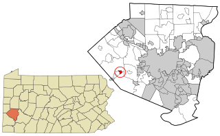
Oakdale is a borough in Allegheny County, Pennsylvania, United States and is a Pittsburgh suburb. The population was 1,459 at the 2010 census. Its zip code is 15071.

Penn Hills is a township with home rule status in Allegheny County, Pennsylvania, United States. The population as of the 2010 census was 42,329. Penn Hills is the second-largest municipality in Allegheny County, after the city of Pittsburgh.

South Fayette Township is a township in Allegheny County, Pennsylvania, United States. The population was 14,416 at the 2010 census.

Imperial is a census-designated place (CDP) in Allegheny County, Pennsylvania, United States and part of the Pittsburgh metropolitan area. The community was formerly part of the Imperial-Enlow CDP before splitting into two separate CDP's. The population was 2,541 at the 2010 census.

This is a list of properties and districts listed on the National Register of Historic Places in Pennsylvania. As of 2015, there are over 3,000 listed sites in Pennsylvania. Sixty-six of the 67 counties in Pennsylvania have listings on the National Register; Cameron County is the only county without any sites listed.
Geographic regions of the Commonwealth of Pennsylvania, United States of America.
Pennsylvania's 31st congressional district was one of Pennsylvania's districts of the United States House of Representatives. It existed from 1903 to 1953.

The West Allegheny School District is a midsized, suburban public school district which is located in the western corner of Allegheny County, approximately 16 miles (26 km) from downtown Pittsburgh. The district comprises Findlay Township, North Fayette Township, and the Oakdale Borough. The district encompasses approximately 59 square miles (150 km2) and is the largest in Allegheny County in terms of geographical area. The West Allegheny School District is home of the Pittsburgh International Airport terminal. West Allegheny was formed in 1949.

Enlow is a census-designated place (CDP) in Allegheny County, Pennsylvania, United States. The community used to be part of the Imperial-Enlow CDP, and was split into two separate CDPs as of the 2010 census. The population was 1,013 at the 2010 census.

Hickory Heights is an unincorporated community of South Fayette Township, Allegheny County, Pennsylvania, United States.

The 44th Pennsylvania House of Representatives District is in Western Pennsylvania and has been represented since 2019 by Valerie Gaydos.
Boyce is an unincorporated community in South Fayette and Upper St. Clair townships, Allegheny County, Pennsylvania, United States. Boyce is located along Chartiers Run 10.5 miles (16.9 km) southwest of downtown Pittsburgh.
Herriottsville is an unincorporated community in South Fayette Township, Allegheny County, Pennsylvania, United States. The community is located in the southeast corner of the township near Chartiers Run. Herriottsville had one of the first post offices in South Fayette Township and was a stagecoach stop on the Black Horse Trail.
The Pittsburgh-New Castle-Weirton, PA-OH-WV Combined Statistical Area is a 12-county Combined Statistical Area in the United States. The principal city of the area is the City of Pittsburgh, Pennsylvania but includes parts of the states of Pennsylvania, West Virginia, and Ohio and was officially defined by the U.S. Census Bureau in 2013. As a CSA, the Census Bureau has identified that the region shares integrated transportation and economic ties as evidenced by commuting patterns. The estimated population of the area was 2,635,228 in mid-2016.
Morgan is an unincorporated community in South Fayette Township, Allegheny County, Pennsylvania, United States. The community is located along Pennsylvania Route 50 9.7 miles (15.6 km) southwest of Pittsburgh. Morgan has a post office with ZIP code 15064.
This page is based on this
Wikipedia article Text is available under the
CC BY-SA 4.0 license; additional terms may apply.
Images, videos and audio are available under their respective licenses.


