Allison Park, Pennsylvania

Last updated

Allison Park, Pennsylvania
Northwood coverd bench.JPG
Bus stop in Allison Park
Allegheny County Pennsylvania incorporated and unincorporated areas Allison Park highlighted.svg
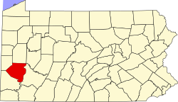
Location in Allegheny County and the U.S. state of Pennsylvania
Coordinates: 40°34′N79°58′W / 40.56°N 79.96°W / 40.56; -79.96
CountryUnited States
State Pennsylvania
County Allegheny
Area
  Total13.86 sq mi (35.90 km2)
Population
 (2020)
  Total21,864
  Density1,577.8/sq mi (4,086.48/km2)
Time zone UTC-5 (Eastern (EST))
  Summer (DST) UTC-4 (EDT)
ZIP code
15101
Area code 412
FIPS code 42-02056

Allison Park is a census-designated place in Allegheny County, Pennsylvania, United States. It is a suburb of Pittsburgh and is located within Hampton, McCandless, Shaler, Indiana and West Deer townships. It had a population of 21,864 at the 2020 census. [1] The ZIP Code for Allison Park is 15101. [2]

Contents

History

Allison Park in the 18th century was called Tally Cavey. Tally Cavey was part of the large Pitt Township. The word Talley Cavey is Irish Gaelic for "hill over the borough". Early Irish settlers named it after Tullycavy on the Ards Peninsula outside Greyabbey, County Down, now in Northern Ireland. [3] The town started in the woods that are now along Mt. Royal Boulevard, and continued until it reached what is now the Pennsylvania Turnpike.

Education

Allison Park is divided amongst the Hampton Township School District, North Allegheny School District Shaler Area School District, and Deer Lakes School District with students attending the schools for the respective municipality they reside in.

Related Research Articles

<span class="mw-page-title-main">Allegheny County, Pennsylvania</span> County in Pennsylvania, United States

Allegheny County is a county in Pennsylvania, United States. It is located in Southwestern Pennsylvania. As of the 2020 census, the population was 1,250,578, making it the state's second-most populous county, after Philadelphia County. Its county seat and most populous city is Pittsburgh, Pennsylvania's second most populous city. Allegheny County is the center of the Pittsburgh, PA metropolitan statistical area and the Pittsburgh media market.

<span class="mw-page-title-main">Fawn Township, Allegheny County, Pennsylvania</span> Township in Pennsylvania, United States

Fawn Township is a township in Allegheny County, Pennsylvania, United States. The population was 2,193 at the 2020 census. The township derives its name either directly after Fahan, County Donegal, Ireland, by Irish settlers of which 'fawn' is the phonetic pronunciation, or indirectly from the York County township of that name with name origin. According to the township itself, Fawn Township derived its name from its parent township, Deer Township, from which it was formed March 28, 1858.

<span class="mw-page-title-main">Indiana Township, Allegheny County, Pennsylvania</span> Township and census-designated place in Pennsylvania, United States

Indiana Township is a township in Allegheny County, Pennsylvania, and a Pittsburgh suburb located in the United States. It contains the communities of Rural Ridge, Dorseyville, and Indianola. The population was 7,254 at the 2020 census.

<span class="mw-page-title-main">Penn Hills, Pennsylvania</span> Home rule township in Pennsylvania, United States

Penn Hills is a township with home rule status in Allegheny County, Pennsylvania, United States. The population was 41,059 as of the 2020 census. A suburb of Pittsburgh, Penn Hills is the second-largest municipality in Allegheny County.

<span class="mw-page-title-main">Sharpsburg, Pennsylvania</span> Borough in Pennsylvania, United States

Sharpsburg is a borough in Allegheny County, Pennsylvania, United States, 5 miles (8 km) northeast of downtown Pittsburgh, along the Allegheny River. In 1900, nearly 7,000 people lived here; in 1920, the population peaked at just over 8,900 people. The population was 3,187 at the 2020 census.

<span class="mw-page-title-main">West Deer Township, Pennsylvania</span> Township in Pennsylvania, United States

West Deer Township is a township in Allegheny County, Pennsylvania, Pennsylvania, United States. The population was 12,262 at the 2020 census.

<span class="mw-page-title-main">Smithton, Pennsylvania</span> Borough in Pennsylvania, United States

Smithton is a borough in Westmoreland County, Pennsylvania, United States. The population was 399 at the 2010 census. As of 2018, the population was listed at 378. Smithton has its own post office, with zip code 15479, and is serviced by Yough School District.

<span class="mw-page-title-main">Hampton Township, Allegheny County, Pennsylvania</span> Township in Pennsylvania, United States

Hampton Township is a township in Allegheny County, Pennsylvania, United States. The population was 18,470 at the 2020 census. It is a suburb of the Pittsburgh metropolitan area.

<span class="mw-page-title-main">McCandless, Pennsylvania</span> Home rule municipality in Pennsylvania, United States

McCandless is a township with home rule status in Allegheny County, Pennsylvania, United States. The population was 29,709 at the 2020 census. It is a northern suburb of the Pittsburgh metropolitan area.

<span class="mw-page-title-main">Shaler Township, Pennsylvania</span> Township in Pennsylvania, United States

Shaler Township is a township in Allegheny County in the U.S. state of Pennsylvania. It consists of much of the community of Glenshaw and several neighboring communities. The population was 28,757 at the 2010 census. It is part of the Pittsburgh metropolitan area.

<span class="mw-page-title-main">Berwyn, Pennsylvania</span> Census-designated place in Pennsylvania, United States

Berwyn is a census-designated place (CDP) in Chester County, Pennsylvania, United States. Berwyn is located within Tredyffrin and Easttown Townships. The area is part of the Philadelphia Main Line suburbs.

<span class="mw-page-title-main">Imperial, Pennsylvania</span> Census-designated place in Pennsylvania, United States

Imperial is a census-designated place (CDP) in Allegheny County, Pennsylvania, United States and part of the Pittsburgh metropolitan area. The population was 2,722 at the 2020 census. The CDP is located in North Fayette and Findlay Townships, and geographically close to Pittsburgh International Airport.

<span class="mw-page-title-main">Clinton, Pennsylvania</span> Census-designated place in Pennsylvania, United States

Clinton is a census-designated place in Findlay Township, Allegheny County, Pennsylvania, United States. It had a population of 905 at the 2020 census. The community is located adjacent to the Pittsburgh International Airport within the Pittsburgh metropolitan area.

<span class="mw-page-title-main">Shaler Area School District</span> School district in Pennsylvania, United States

Shaler Area School District is a large, urban and suburban public school district located in Allegheny County, Pennsylvania. Shaler Area School District encompasses approximately 14 square miles (36 km2) in Pittsburgh's northern suburbs, including Shaler Township, Etna Borough, Millvale Borough, and Reserve Township. According to 2000 federal census data, it served a resident population of 41,565. By 2010, the district's population declined to 39,293 people. In 2009, Shaler Area School District residents’ per capita income was $21,333, while the median family income was $52,135. In the Commonwealth, the median family income was $49,501 and the United States median family income was $49,445, in 2010. By 2013, the median household income in the United States rose to $52,100.

The North Hills is the northern suburbs of Pittsburgh, Pennsylvania. The independent suburban municipalities that are included in the North Hills are Ross Township, Borough of West View, Shaler Township, West Deer Township, Franklin Park, Marshall Township, Bradford Woods, McCandless Township, Hampton Township, Pine Township, Richland Township, Borough of Fox Chapel, Indiana Township, O'Hara Township, Reserve Township, Ohio Township, Kilbuck Township.

<span class="mw-page-title-main">Gibsonia, Pennsylvania</span> Census-designated place in Pennsylvania, United States

Gibsonia is an unincorporated community and census-designated place in Richland Township, Allegheny County, in the U.S. state of Pennsylvania, north of the city of Pittsburgh.

The 28th Pennsylvania House of Representatives District is in southwestern Pennsylvania and has been represented by Rob Mercuri since 2021.

<span class="mw-page-title-main">Bairdford, Pennsylvania</span> Census-designated place in Pennsylvania, United States

Bairdford is a census-designated place within the township of West Deer in Allegheny County, Pennsylvania, United States. As of the 2020 census, it had a population of 855 with a median age of 44. There are 692 people classified as white, three as black, three as combination White and American Indian. There are eight people who identify as Latino. The town was built to house coal miners.

<span class="mw-page-title-main">Bakerstown, Pennsylvania</span> Census-designated place in Pennsylvania, United States

Bakerstown is a census-designated place within Richland Township in Allegheny County, Pennsylvania, United States. As of the 2020 census, it had a population of 2,745. Despite Bakerstown's small size, there are a few shops located within the settlement. Bakerstown is also home to the Richland Township Community Park.

<span class="mw-page-title-main">Foot of Ten, Pennsylvania</span> Census-designated place in Pennsylvania, United States

Foot of Ten is a census-designated place in Allegheny and Juniata Townships in Blair County, Pennsylvania, United States. It is located approximately one mile west of the small borough Duncansville on Foot of Ten Road, and about 2.5 miles (4 km) north of the even smaller borough Newry. It is often considered a region of Duncansville, despite lying outside the borough limits. As of the 2010 census, the population was 672 residents.

References

  1. "Race, Hispanic or Latino, Age, and Housing Occupancy: 2010 Census Redistricting Data (Public Law 94-171) Summary File (QT-PL), Allison Park CDP, Pennsylvania". United States Census Bureau . Retrieved September 30, 2011.
  2. "Allison Park PA ZIP Code". zipdatamaps.com. 2023. Retrieved May 13, 2023.
  3. "From Rostrevor to Raphoe: An Overview of Ulster Place-Names in Pennsylvania, 1700-1820 | Peter Gilmore - Academia.edu". Archived from the original on February 18, 2013. Retrieved November 1, 2017.