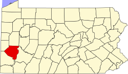
Industry, Allegheny County, Pennsylvania

Last updated
Industry, Pennsylvania
USA Pennsylvania location map.svg
Red pog.svg
Industry
Usa edcp location map.svg
Red pog.svg
Industry
Coordinates: 40°15′59″N79°47′35″W / 40.26639°N 79.79306°W / 40.26639; -79.79306
Country United States
State Pennsylvania
County Allegheny
Area
  Total0.290 sq mi (0.75 km2)
  Land0.258 sq mi (0.67 km2)
  Water0.032 sq mi (0.08 km2)
Elevation
784 ft (239 m)
Time zone UTC-5 (Eastern (EST))
  Summer (DST) UTC-4 (EDT)
Area code 724

Industry is an unincorporated community and census-designated place in Allegheny County, Pennsylvania. [1] [2]

Related Research Articles

<span class="mw-page-title-main">Goshen, New Jersey</span> Populated place in Cape May County, New Jersey, US

Goshen is an unincorporated community and census-designated place (CDP) located within Middle Township, in Cape May County, in the U.S. state of New Jersey.

<span class="mw-page-title-main">East Millstone, New Jersey</span> Populated place in Somerset County, New Jersey, US

East Millstone is an unincorporated community and census-designated place (CDP) located in Franklin Township in Somerset County, in the U.S. state of New Jersey.

<span class="mw-page-title-main">Pottersville, New Jersey</span> Populated place in Hunterdon and Somerset counties, New Jersey, US

Pottersville is an unincorporated community and census-designated place (CDP) split between Bedminster Township in Somerset County and Tewksbury Township in Hunterdon County, in the U.S. state of New Jersey. The area is served as United States Postal Service ZIP Code 07979. As of the 2010 United States Census, the population for ZIP Code Tabulation Area 07979 was 589. In 1990, most of the village was listed on the National Register of Historic Places as the Pottersville Village Historic District.

<span class="mw-page-title-main">Matheson, Colorado</span> Census-designated place in Elbert County, Colorado, United States.

Matheson is a census-designated place (CDP) and post office in and governed by Elbert County, Colorado, United States. The CDP is a part of the Denver–Aurora–Lakewood, CO Metropolitan Statistical Area. The Matheson post office has the ZIP Code 80830. At the United States Census 2020, the population of the Matheson CDP was 79.

<span class="mw-page-title-main">Dennisville, New Jersey</span> Populated place in Cape May County, New Jersey, US

Dennisville is an unincorporated community and census-designated place (CDP) located within Dennis Township, in Cape May County, in the U.S. state of New Jersey. It is part of the Ocean City Metropolitan Statistical Area. Its postal ZIP Code is 08214.

Leesburg is an unincorporated community and census-designated place (CDP) located within Maurice River Township in Cumberland County, in the U.S. state of New Jersey. The area is served as United States Postal Service ZIP Code 08327.

<span class="mw-page-title-main">Brookside, New Jersey</span> Place in Morris County, New Jersey, United States

Brookside is a historic unincorporated community and census-designated place (CDP) located within Mendham Township in Morris County, in the U.S. state of New Jersey. It is located approximately 6 mi (9.7 km) west of Morristown. It is close to the Washington Valley Historic District in neighboring Morris Township.

<span class="mw-page-title-main">Salem Metropolitan Statistical Area</span> Metropolitan statistical area in Oregon, United States

The Salem Metropolitan Statistical Area (MSA), as defined by the United States Census Bureau, is a Metropolitan Statistical Area consisting of two counties in western Oregon, Marion and Polk. The principal city is Salem, the state capital, which has a population of 175,535. The Salem MSA had a population of 433,353 at the 2020 census. In 2010, there were 390,738 people living in the Salem MSA. In 2000, the MSA had a population of 347,214, and had a population of 278,024 according to the 1990 census.

<span class="mw-page-title-main">Cooke City, Montana</span> Census-designated place in Montana, United States

Cooke City is an unincorporated community and census-designated place (CDP) in Park County, Montana, United States. As of the 2020 census, it had a population of 77. Prior to 2010, it was part of the Cooke City-Silver Gate CDP.

Pleasant View is a census-designated place (CDP) in Armstrong County, Pennsylvania, United States. The population was 677 at the 2020 census. Pleasant View was formerly part of the census-designated place of North Vandergrift-Pleasant View at the 2000 Census, before splitting into two separate CDPs for the 2010 census.

Colony Park is a census-designated place in Spring Township, Berks County, Pennsylvania, United States. It is located just off U.S. 222, approximately one mile northwest of the borough of Wyomissing. As of the 2010 census, the population was 1,076 residents.

Grazierville is a census-designated place in Snyder Township, Blair County, Pennsylvania, United States. It is located near I-99 and is approximately one mile to the south of the borough of Tyrone. As of the 2010 census, the population was 665 residents.

<span class="mw-page-title-main">Acacia Villas, Florida</span> CDP in Florida, United States

Acacia Villas is a census-designated place in Palm Beach County, Florida, United States. It is part of the Miami metropolitan area of South Florida. The population was 398 as of the 2020 census.

<span class="mw-page-title-main">Castleton (CDP), Vermont</span> Census-designated place in Vermont, United States

Castleton is the primary village and a census-designated place (CDP) in the town of Castleton, Rutland County, Vermont, United States. As of the 2020 census, it had a population of 1,337, out of 4,458 in the entire town. A large portion of the village is part of the Castleton Village Historic District, listed on the National Register of Historic Places in 1979. It is also home to Castleton University, founded in 1787, and now part of the Vermont State Colleges system.

Encore at Monroe is a gated community and census-designated place (CDP) located in Monroe Township, Middlesex County, in the U.S. state of New Jersey. It is in the western part of the township, bordered to the south by Clearbrook. It is 3 miles (5 km) southwest of Jamesburg, 15 miles (24 km) south of New Brunswick, 6 miles (10 km) northeast of Hightstown, and 18 miles (29 km) northeast of Trenton.

Forsgate is a golf course community and census-designated place (CDP) located in Monroe Township, Middlesex County, in the U.S. state of New Jersey. It consists of Forsgate Country Club and its associated housing developments. It is in the northwestern part of the township, bordered to the south across Forsgate Drive by Rossmoor, to the east by the Hightstown Industrial Track rail line, to the north by a branch rail line connecting Jamesburg and Monmouth Junction, and to the west by the New Jersey Turnpike at Exit 8A. It is 13 miles (21 km) south of New Brunswick and 19 miles (31 km) northeast of Trenton.

Monroe Manor is a census-designated place (CDP) located in Monroe Township, Middlesex County, in the U.S. state of New Jersey. It is in the southernmost part of Middlesex County and consists of the developments of Monroe Manor and Monroe Place. It is bordered to the south by Millstone Township in Monmouth County and to the west by the Renaissance at Monroe development. New Jersey Route 33 forms the northern border of the CDP, leading west 2.5 miles (4.0 km) to Hightstown and east 11 miles (18 km) to Freehold.

Regency at Monroe is a gated community and census-designated place (CDP) located in Monroe Township, Middlesex County, in the U.S. state of New Jersey. It is in the eastern part of the township, bordered by Mounts Mills Road to the north, Spotswood-Englishtown Road to the east, and Buckelew Avenue to the southwest. It is 7 miles (11 km) northwest of Freehold, 15 miles (24 km) south-southeast of New Brunswick, and 22 miles (35 km) northeast of Trenton.

References

  1. "2023 U.S. Gazetteer Files". United States Census Bureau. 2023. Retrieved 3 October 2023.
  2. "Industry Census Designated Place". Geographic Names Information System . United States Geological Survey, United States Department of the Interior . Retrieved October 4, 2023.