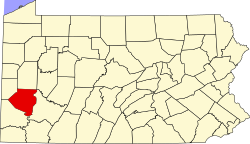
Edgewood, Pennsylvania | |
---|---|
Coordinates: 40°25′55″N79°53′4″W / 40.43194°N 79.88444°W Coordinates: 40°25′55″N79°53′4″W / 40.43194°N 79.88444°W | |
Country | United States |
State | Pennsylvania |
County | Allegheny |
Incorporated | 1888-12-01 [1] |
Government | |
• Type | Mayor–council |
• Mayor | J. Edward Cook (D) [2] |
Area | |
• Total | 0.59 sq mi (1.52 km2) |
• Land | 0.59 sq mi (1.52 km2) |
• Water | 0.00 sq mi (0.00 km2) |
Elevation | 978 ft (298 m) |
Population | |
• Total | 3,145 |
• Density | 5,348.64/sq mi (2,065.49/km2) |
Time zone | UTC-5 (Eastern (EST)) |
• Summer (DST) | UTC-4 (EDT) |
ZIP code | 15218 |
Area code | 412 |
FIPS code | 42-22520 [6] |
GNIS feature ID | U.S. Geological Survey Geographic Names Information System: 1174013 |
Website | www |
Edgewood is a borough in Allegheny County, Pennsylvania, United States, adjacent to the city of Pittsburgh. The population was 3,145 at the 2020 census. [7]
Edgewood was incorporated on December 1, 1888. [1] Its historic landmarks include the Edgewood Borough Building where the police and fire service are also housed; the First Presbyterian Church of Edgewood; the Edgewood Community House which is home to both CC Mellor Memorial Library and the Edgewood Club; Memorial Park; Koenig Community Field and Field House; Edgewood Primary School (which was originally a K-12 in Edgewood's own district but was incorporated into the Woodland Hills School District merger in 1982, and most recently serves as a K-6 school building); and a historic train station. The Gardner-Bailey House is on the National Register of Historic Places.
Union Switch & Signal's primary factory was located near here for 106 years prior to its closure in 1986. [8] Its site is currently being used as a shopping center, Edgewood Towne Centre, which was established in 1990. [9]
Edgewood is located at 40°25′55″N79°53′4″W / 40.43194°N 79.88444°W (40.431868, -79.884321). [10]
According to the United States Census Bureau, the borough has a total area of 0.6 square miles (1.6 km2), all land.
Year | Republican | Democratic | Third Parties |
---|---|---|---|
2020 | 13%329 | 85%2,025 | 0.6%15 |
2016 | 15%320 | 81%1,695 | 4%77 |
2012 | 26%530 | 72%1,452 | 2%36 |
Edgewood has four borders, including Wilkinsburg to the north, Braddock Hills to the east and southeast, Swissvale to the south and west, and the Pittsburgh neighborhood of Regent Square to the northwest.
Census | Pop. | Note | %± |
---|---|---|---|
1880 | 218 | — | |
1890 | 616 | 182.6% | |
1900 | 1,139 | 84.9% | |
1910 | 2,596 | 127.9% | |
1920 | 3,181 | 22.5% | |
1930 | 4,821 | 51.6% | |
1940 | 4,697 | −2.6% | |
1950 | 5,292 | 12.7% | |
1960 | 5,124 | −3.2% | |
1970 | 5,138 | 0.3% | |
1980 | 4,382 | −14.7% | |
1990 | 3,581 | −18.3% | |
2000 | 3,311 | −7.5% | |
2010 | 3,118 | −5.8% | |
2020 | 3,145 | 0.9% | |
Sources: [6] [14] [15] [16] [17] [5] |
At the 2010 United States Census, there were 3,118 people residing in Edgewood, a decrease of 5.8% since 2000. Of that total, 85.1% (2,653) identified themselves as White, 9.3% (290) as Black or African American, 2.6% (81) as Asian, 0.3% (10) as American Indian and Alaska Native, 0.6% (19) as Other, and 2.1% (65) as Multiracial. There were 2.7% (84) of the population who identified as Hispanic or Latino (of any race). [18]
At the 2000 census, [6] there were 3,311 people, 1,639 households and 824 families residing in the borough. The population density was 5,600.2 per square mile (2,166.8/km2). There were 1,730 housing units at an average density of 2,926.1/sq mi (1,132.1/km2). The racial makeup of the borough was 89.13% White, 7.85% African American, 0.12% Native American, 1.48% Asian, 0.09% Pacific Islander, 0.51% from other races, and 0.82% from two or more races. Hispanic or Latino of any race were 1.36% of the population.
There were 1,639 households, of which 19.5% had children under the age of 18 living with them, 39.3% were married couples living together, 8.4% had a female householder with no husband present, and 49.7% were non-families. 40.4% of all households were made up of individuals, and 9.9% had someone living alone who was 65 years of age or older. The average household size was 1.99 and the average family size was 2.75.
Age distribution was 17.4% under the age of 18, 7.1% from 18 to 24, 34.6% from 25 to 44, 27.0% from 45 to 64, and 13.9% who were 65 years of age or older. The median age was 40 years. For every 100 females, there were 85.8 males. For every 100 females age 18 and over, there were 81.1 males.
The median household income was $52,153, and the median family income was $68,281. Males had a median income of $47,292 versus $38,950 for females. The per capita income for the borough was $39,188. About 1.8% of families and 4.8% of the population were below the poverty line, including 8.0% of those under age 18 and 1.5% of those age 65 or over.
Edgewood is governed by a mayor and borough council under the administration of Mayor Jack Wilson (D), who took office in 2017. [2] The council is composed of seven members:
Councilman Wainright is the president of the council. [19]
Edgewood Borough is served by the Woodland Hills School District.
Brackenridge is a borough in Allegheny County, Pennsylvania, United States, located along the Allegheny River. It is part of the Greater Pittsburgh metropolitan area.
Chalfant is a borough in Allegheny County, Pennsylvania, United States. The population was 748 at the 2020 census.
East McKeesport is a borough in Allegheny County, Pennsylvania, United States, and is part of the Pittsburgh Metro Area. The population was 2,076 at the 2020 census.
East Pittsburgh is a borough in Allegheny County, Pennsylvania, United States, approximately 11 miles (18 km) southeast of the confluence of the Monongahela and the Allegheny rivers at Pittsburgh. The population in 1900 stood at 2,883, and in 1910, at 5,615. As of the 2020 census, the borough population was 1,927, having fallen from 6,079 in 1940. George Westinghouse erected large works there which supplied equipment to the great power plants at Niagara Falls and for the elevated and rapid-transit systems of New York. Nearby, the George Westinghouse Bridge over Turtle Creek is a prominent fixture in the area, which is very near the borough of Braddock.
Elizabeth is a borough in Allegheny County, Pennsylvania, United States, on the east bank of the Monongahela River, where Pennsylvania Route 51 crosses, 15 miles (24 km) upstream (south) of Pittsburgh and close to the county line. The population was 1,398 at the 2020 census. The borough of Elizabeth is entirely contained within the 15037 USPS ZIP code. The local school district is the Elizabeth Forward School District. The borough is home to neighborhoods Walker Heights and Town Hill. Elizabeth Borough is the birthplace of Town Hill Hockey established in 1978.
Etna is a borough of Allegheny County, Pennsylvania, United States, located across the Allegheny River from Pittsburgh. In 2019, Etna was recognized as the first ever Ecodistrict.
Forest Hills is a borough in Allegheny County, Pennsylvania, United States. The population was 6,429 at the 2020 census, as compared to 6,831 in 2000, and 7,335 in 1990.
Franklin Park is a borough in Allegheny County, Pennsylvania, United States. The population was 15,479 at the 2020 census. It is a suburb of the Pittsburgh metropolitan area.
Heidelberg is a borough located southwest of Pittsburgh in Allegheny County, Pennsylvania, United States. The population was 1,288 at the 2020 census. The borough was named after Heidelberg in Germany, the native home of a large share of the early settlers.
Ingram is a borough in Allegheny County, Pennsylvania, United States. The population was 3,391 at the 2020 census.
Liberty is a borough in Allegheny County, Pennsylvania, United States. The population was 2,355 at the 2020 census.
Lincoln is a borough in Allegheny County, Pennsylvania, United States. The population was 932 at the 2020 United States Census.
Mount Oliver is a borough in Allegheny County, Pennsylvania, United States. It is a largely residential area situated atop a crest about 3 miles (5 km) west of the Monongahela River. The borough is surrounded entirely by the city of Pittsburgh, having resisted annexations by the city, as it prefers to manage its own local needs and finances.
Rankin is a borough in Allegheny County, Pennsylvania, United States, 8 miles (13 km) south of Pittsburgh on the Monongahela River. The borough was named after Thomas Rankin, a local landowner. Early in the 20th century, Rankin specialized in manufacturing steel and wire goods. The population increased from 3,775 in 1900 to 7,470 in 1940, and has since declined to 1,896 as of the 2020 census.
Sewickley Hills is a borough in Allegheny County, Pennsylvania, United States. The population was 689 at the 2020 census.
Swissvale is a borough in Allegheny County, Pennsylvania, United States, 9 miles (14 km) east of downtown Pittsburgh. Named for a farmstead owned by James Swisshelm, during the industrial age it was the site of the Union Switch and Signal Company of George Westinghouse. The population was 8,624 at the 2020 census. In 1940, 15,919 people lived there.
Verona is a borough in Allegheny County, Pennsylvania, United States. It is 13 miles (21 km) northeast of downtown Pittsburgh, along the left bank of the Allegheny River. As of the 2020 census, the borough had a population of 2,492.
Versailles is a borough in Allegheny County, Pennsylvania, United States. At the 2020 census, the population was 1,476.
West Kittanning is a borough in Armstrong County, Pennsylvania, United States. The population was 1,175 at the 2010 census.
Wilkins Township is a township in Allegheny County, Pennsylvania, United States. The population was 6,357 at the 2010 census. It is served by Pennsylvania's 12th congressional district, the 43rd District of the Pennsylvania State Senate, and the 34th District of the Pennsylvania State House of Representatives.