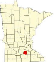
Le Sueur County is a county in the U.S. state of Minnesota. As of the 2010 United States Census, the population was 27,703. Its county seat is Le Center.
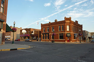
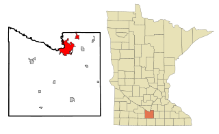
Le Center is a city in Le Sueur County, Minnesota, United States. The population was 2,499 at the 2010 census. It is the county seat of Le Sueur County. The Le Sueur County Courthouse and Jail are listed on the National Register of Historic Places.
Mankato is a city in Blue Earth, Nicollet, and Le Sueur counties in the state of Minnesota. The population was 42,610 according to 2018 US census estimates, making it the fifth largest city in Minnesota outside the Minneapolis–Saint Paul metropolitan area. The county seat of Blue Earth County, it is along a large bend of the Minnesota River at its confluence with the Blue Earth River. Mankato is across the Minnesota River from North Mankato. Mankato and North Mankato have a combined population of over 56,500 according to the 2018 census estimates. It completely encompasses the town of Skyline. North of Mankato Regional Airport, a tiny non-contiguous part of the city lies within Le Sueur County. Most of the city is in Blue Earth County.

Le Sueur is a city in Le Sueur and Sibley counties in the U.S. state of Minnesota, between Mankato and the Twin Cities. It lies along the Minnesota River and U.S. Highway 169. Le Sueur was named in honor of the French explorer Pierre-Charles Le Sueur. The population was 4,058 at the 2010 census.
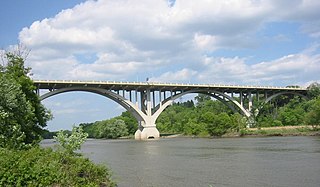
The Minnesota River is a tributary of the Mississippi River, approximately 332 miles (534 km) long, in the U.S. state of Minnesota. It drains a watershed of nearly 17,000 square miles (44,000 km2), 14,751 square miles (38,200 km2) in Minnesota and about 2,000 sq mi (5,200 km2) in South Dakota and Iowa.

The Blue Earth River is a tributary of the Minnesota River, 108 miles (174 km) long, in southern Minnesota in the United States. Two of its headwaters tributaries, the Middle Branch Blue Earth River and the West Branch Blue Earth River, also flow for short distances in northern Iowa. By volume, it is the Minnesota River's largest tributary, accounting for 46% of the Minnesota's flow at the rivers' confluence in Mankato. Via the Minnesota River, the Blue Earth River is part of the watershed of the Mississippi River, draining an area of 3,486 square miles (9,029 km²) in an agricultural region. Ninety percent of the river's watershed is in Minnesota. It is a Minnesota Department of Natural Resources designated Water Trail.

The Le Sueur River (lay-SEWER) is a tributary of the Blue Earth River, 111 miles (178 km) long, in southern Minnesota in the United States. Via the Blue Earth and Minnesota Rivers, it is part of the watershed of the Mississippi River, draining an area of 1,089 square miles (2,280 km²). It is the largest tributary of the Blue Earth River, draining 31% of its watershed.
Minnesota State Highway 112 was a 15.012-mile-long (24.159 km) highway in south-central Minnesota, which ran from its interchange with U.S. Highway 169 in the city of Le Sueur and continued south and then east to its eastern terminus at its intersection with State Highway 99 in Lexington Township near the city of Le Center.

Union Hill is an unincorporated community in Le Sueur and Scott counties in the U.S. state of Minnesota.
Ottawa is an unincorporated community in Ottawa Township, Le Sueur County, Minnesota, United States.
Cordova is an unincorporated community in Cordova Township, Le Sueur County, Minnesota, United States.
Greenland is an unincorporated community in Elysian Township, Le Sueur County, Minnesota, United States.
St. Thomas is an unincorporated community in Derrynane Township, Le Sueur County, Minnesota, United States.
Lexington is an unincorporated community in Lexington Township, Le Sueur County, Minnesota, United States.
Marysburg is an unincorporated community in Blue Earth and Le Sueur counties in the U.S. state of Minnesota.
Henderson Station is an unincorporated community in Tyrone Township, Le Sueur County, Minnesota, United States. The community is also known as East Henderson. It is 1.3 mile east of Henderson, and six miles north of Le Sueur.
Rush River is an unincorporated community in Kelso Township, Sibley County, Minnesota, United States, near Le Sueur.
Wilton is an unincorporated community in Wilton Township, Waseca County, Minnesota, United States, near Waseca. The community is located near the junction of Waseca County Roads 4 and 23. The Le Sueur River flows through the community.
St. Mary is an unincorporated community in St. Mary Township, Waseca County, Minnesota, United States, near Waseca. The community is located near the junction of Waseca County Roads 9 and 29, and 320th Avenue. The Le Sueur River flows nearby.