Waseca County is a county in the U.S. state of Minnesota. As of the 2010 United States Census, the population was 19,136. Its county seat is Waseca.

Le Sueur County is a county in the U.S. state of Minnesota. As of the 2010 United States Census, the population was 27,703. Its county seat is Le Center.

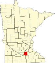
Blue Earth County is a county in the State of Minnesota. As of the 2010 United States Census, the population was 64,013. Its county seat is Mankato. The county is named for the Blue Earth River and for the deposits of blue-green clay once evident along the banks of the Blue Earth River.

Jamestown Township is a township in Blue Earth County, Minnesota, United States. The population was 628 as of the 2000 census.
Le Ray Township is a township in Blue Earth County, Minnesota, United States. The population was 846 as of the 2000 census.
Lime Township is a township in Blue Earth County, Minnesota, United States. The population was 1,395 as of the 2010 census.

The Le Sueur River (lay-SEWER) is a tributary of the Blue Earth River, 111 miles (178 km) long, in southern Minnesota in the United States. Via the Blue Earth and Minnesota Rivers, it is part of the watershed of the Mississippi River, draining an area of 1,089 square miles (2,280 km²). It is the largest tributary of the Blue Earth River, draining 31% of its watershed.
There are many lakes named Mud Lake in the U.S. state of Minnesota, including:
Union Hill is an unincorporated community in Le Sueur and Scott counties in the U.S. state of Minnesota.
Ottawa is an unincorporated community in Ottawa Township, Le Sueur County, Minnesota, United States.
Cordova is an unincorporated community in Cordova Township, Le Sueur County, Minnesota, United States.
Greenland is an unincorporated community in Elysian Township, Le Sueur County, Minnesota, United States.
St. Henry is an unincorporated community in Sharon Township, Le Sueur County, Minnesota, United States.
St. Thomas is an unincorporated community in Derrynane Township, Le Sueur County, Minnesota, United States.
Lexington is an unincorporated community in Lexington Township, Le Sueur County, Minnesota, United States.
Henderson Station is an unincorporated community in Tyrone Township, Le Sueur County, Minnesota, United States. The community is also known as East Henderson. It is 1.3 mile east of Henderson, and six miles north of Le Sueur.
Smiths Mill is an unincorporated community in Blue Earth and Waseca counties in the U.S. state of Minnesota. The community is located along 631st Avenue near 206th Street and U.S. Highway 14. Smiths Mill is located within Le Ray Township in Blue Earth County; and also located within Janesville Township in Waseca County. Nearby places include Janesville and Eagle Lake.
Alma City is an unincorporated community in Waseca County, Minnesota, United States, south of Janesville.

The Shanaska Creek Bridge, also called Washington Park Bridge and officially Bridge 4846, is an iron 8 panel pin-connected Pratt through truss bridge which was erected in 1875 over the Blue Earth River in the U.S. State of Minnesota and moved twice since. It was built near Vernon Center, Minnesota by Soulerin, James, and Company of Milwaukee, Wisconsin.