Heidelberg, Minnesota

Last updated

Heidelberg, Minnesota
Le Sueur County Minnesota Incorporated and Unincorporated areas Heidelberg Highlighted.svg
Location of Heidelberg, Minnesota
Coordinates: 44°30′01″N93°37′42″W / 44.50028°N 93.62833°W / 44.50028; -93.62833
CountryUnited States
State Minnesota
County Le Sueur
PlattedDecember 4, 1878
Incorporated June 26, 1894
Government
   Mayor Lori Weldon
Area
[1]
  Total0.524 sq mi (1.356 km2)
  Land0.524 sq mi (1.356 km2)
  Water0.000 sq mi (0.000 km2)
Elevation
[2]
1,053 ft (321 m)
Population
 (2020) [3]
  Total137
  Estimate 
(2022) [4]
132
  Density261.45/sq mi (101.01/km2)
Time zone UTC–6 (Central (CST))
  Summer (DST) UTC–5 (CDT)
ZIP Code
56071
Area code 952
FIPS code 27-28214
GNIS feature ID2394346 [2]
Sales tax 7.375% [5]
Website cityofheidelbergmn.com

Heidelberg is a city in Le Sueur County, Minnesota, United States. The population was 137 at the 2020 census. [3]

Contents

Geography

According to the United States Census Bureau, the city has a total area of 0.524 square miles (1.36 km2), all land. [1]

County Highway 28 serves as a main route in the community. Minnesota State Highway 13 passes nearby.

History

Heidelberg was platted on December 4, 1878, and named by its original German settlers (Frank Heil and Frederick Ihrig) after Heidelberg, in Germany. [6] A post office operated in the community from 1872 until 1903. [7] Heidelberg was incorporated on June 26, 1894. [6]

Demographics

Historical population
CensusPop.Note
1900 114
1910 111−2.6%
1920 73−34.2%
1930 56−23.3%
1940 7126.8%
1950 61−14.1%
1960 44−27.9%
1970 7263.6%
1980 10241.7%
1990 73−28.4%
2000 72−1.4%
2010 12269.4%
2020 13712.3%
2021 (est.)132 [4] −3.6%
U.S. Decennial Census [8]
2020 Census [3]

The median income for a household in the city as of 2009 was $69,686. The per capita income for the city was $25,398. None of the population or the families were below the poverty line.

2010 census

As of the 2010 census, there were 122 people, 41 households, and 34 families residing in the city. The population density was 230.2 inhabitants per square mile (88.9/km2). There were 47 housing units at an average density of 88.7 per square mile (34.2/km2). The racial makeup of the city was 100.0% White. Hispanic or Latino of any race were 1.6% of the population.

There were 41 households, of which 51.2% had children under the age of 18 living with them, 75.6% were married couples living together, 4.9% had a female householder with no husband present, 2.4% had a male householder with no wife present, and 17.1% were non-families. 12.2% of all households were made up of individuals, and 4.9% had someone living alone who was 65 years of age or older. The average household size was 2.98 and the average family size was 3.32.

The median age in the city was 40.3 years. 33.6% of residents were under the age of 18; 2.4% were between the ages of 18 and 24; 27.9% were from 25 to 44; 25.4% were from 45 to 64; and 10.7% were 65 years of age or older. The gender makeup of the city was 55.7% male and 44.3% female.

Related Research Articles

<span class="mw-page-title-main">Foley, Minnesota</span> City in Minnesota, United States

Foley is a city and the county seat of Benton County, Minnesota, United States. The population was 2,711 at the 2020 census.

<span class="mw-page-title-main">Odessa, Minnesota</span> City in Minnesota, United States

Odessa is a city in Big Stone County, Minnesota, United States. The population was 103 at the 2020 census.

<span class="mw-page-title-main">St. Clair, Minnesota</span> City in Minnesota, United States

St. Clair or Saint Clair is a city in Blue Earth County, Minnesota, United States, located along the Le Sueur River. The population was 750 at the 2020 census. It is part of the Mankato-North Mankato Metropolitan Statistical Area.

<span class="mw-page-title-main">Comstock, Minnesota</span> City in Minnesota, United States

Comstock is a city in Clay County, Minnesota, United States. The population was 100 at the 2020 census.

<span class="mw-page-title-main">Emily, Minnesota</span> City in Minnesota, United States

Emily is a city in Crow Wing County, Minnesota, United States. The population was 843 at the 2020 census. It is part of the Brainerd Micropolitan Statistical Area.

<span class="mw-page-title-main">Trommald, Minnesota</span> City in Minnesota, United States

Trommald is a city in Crow Wing County, Minnesota, United States. The population was 99 at the 2020 census. It is part of the Brainerd Micropolitan Statistical Area.

<span class="mw-page-title-main">Effie, Minnesota</span> City in Minnesota, United States

Effie( EF-ee) is a city in Itasca County, Minnesota, United States. The population was 109 at the 2020 census.

<span class="mw-page-title-main">Sunburg, Minnesota</span> City in Minnesota, United States

Sunburg is a city in Kandiyohi County, Minnesota, United States. The population was 94 at the 2020 census.

<span class="mw-page-title-main">Cleveland, Minnesota</span> City in Minnesota, United States

Cleveland is a city in Le Sueur County, Minnesota, United States. The population was 719 at the 2010 census and 747 at the 2020 census.

<span class="mw-page-title-main">Kilkenny, Minnesota</span> City in Minnesota, United States

Kilkenny is a city in Le Sueur County, Minnesota, United States. The population was 134 at the 2010 census.

<span class="mw-page-title-main">Le Center, Minnesota</span> City in Minnesota, United States

Le Center is a city and the county seat of Le Sueur County, Minnesota, United States. The population was 2,517 at the 2020 census. The Le Sueur County Courthouse and Jail are listed on the National Register of Historic Places.

<span class="mw-page-title-main">Waterville, Minnesota</span> City in Minnesota, United States

Waterville is a town in Le Sueur County, Minnesota, United States. The population was 1,868 at the 2010 census. It is close to Sakatah Lake State Park on the Cannon River.

<span class="mw-page-title-main">Hillman, Minnesota</span> City in Minnesota, United States

Hillman is a city in Morrison County, Minnesota, United States. The population was 23 at the 2020 census.

<span class="mw-page-title-main">Lastrup, Minnesota</span> City in Minnesota, United States

Lastrup is a city in Morrison County, Minnesota, United States. The population was 120 at the 2020 census.

<span class="mw-page-title-main">Erhard, Minnesota</span> City in Minnesota, United States

Erhard is a city in Otter Tail County, Minnesota, United States. The population was 132 at the 2020 census.

<span class="mw-page-title-main">Urbank, Minnesota</span> City in Minnesota, United States

Urbank is a city in Otter Tail County, Minnesota, United States. The population was 52 at the 2020 census.

<span class="mw-page-title-main">McKinley, St. Louis County, Minnesota</span> City in Minnesota, United States

McKinley is a city in Saint Louis County, Minnesota, United States; located within the Iron Range region of Minnesota. The population was 103 at the 2020 census.

<span class="mw-page-title-main">Barnesville, Minnesota</span> City in Minnesota, United States

Barnesville is a city in Clay County, Minnesota, United States. The population was 2,759 at the 2020 census.

<span class="mw-page-title-main">Elysian, Minnesota</span> City in Minnesota, United States

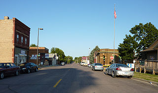
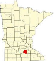
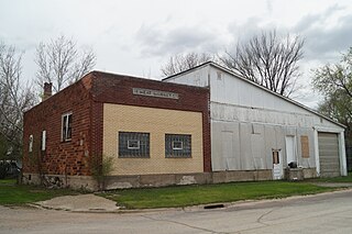
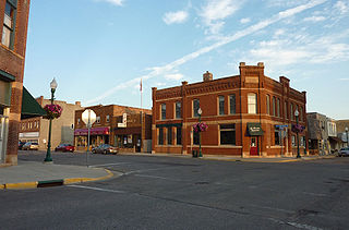
Elysian is a city in Le Sueur and Waseca counties in the U.S. state of Minnesota. The population was 708 at the 2020 Census. The city is distinct from Elysian Township.

<span class="mw-page-title-main">Minneiska, Minnesota</span> City in Minnesota, United States

Minneiska is a city in Wabasha and Winona counties in the U.S. state of Minnesota. The population was 97 at the 2020 census.

References

  1. 1 2 "2023 U.S. Gazetteer Files". United States Census Bureau. Retrieved July 24, 2022.
  2. 1 2 U.S. Geological Survey Geographic Names Information System: Heidelberg, Minnesota
  3. 1 2 3 "Explore Census Data". United States Census Bureau . Retrieved February 8, 2024.
  4. 1 2 "City and Town Population Totals: 2020-2022". United States Census Bureau. February 8, 2024. Retrieved February 8, 2024.
  5. "Heidelberg (MN) sales tax rate" . Retrieved February 8, 2024.
  6. 1 2 Upham, Warren (1920). Minnesota Geographic Names: Their Origin and Historic Significance. Minnesota Historical Society. p.  301.
  7. "Le Sueur County County". Jim Forte Postal History. Retrieved July 18, 2015.
  8. "Census of Population and Housing". census.gov. Retrieved June 4, 2015.