St. Michael-Sidman, Pennsylvania

Last updated

St. Michael-Sidman
Former CDP
South Fork Fishing and Hunting Clubhouse.jpg
Clubhouse for the former South Fork Fishing and Hunting Club
Map of St. Michael-Sidman, Cambria County, Pennsylvania Highlighted.png
Location within Cambria County
USA Pennsylvania location map.svg
Red pog.svg
St. Michael-Sidman
Location within the U.S. state of Pennsylvania
Coordinates: 40°19′55″N78°45′37″W / 40.33194°N 78.76028°W / 40.33194; -78.76028
Country United States
State Pennsylvania
County Cambria
Area
  Total2.0 sq mi (5.3 km2)
Population
 (2000)
  Total973
  Density480/sq mi (180/km2)
Time zone UTC-5 (Eastern (EST))
  Summer (DST) UTC-4 (EDT)

St. Michael-Sidman was a census-designated place (CDP) in Cambria County, Pennsylvania, United States. The population was 973 at the 2000 census. For the 2010 census, the area was split into two CDPs, St. Michael and Sidman.

Contents

Geography

St. Michael-Sidman was located at 40°19′55″N78°45′37″W / 40.33194°N 78.76028°W / 40.33194; -78.76028 (40.331874, -78.760371). [1]

According to the United States Census Bureau, the CDP had a total area of 2.0 square miles (5.2 km2), of which 2.0 square miles (5.2 km2) was land and 0.49% was water.

Demographics

As of the census [2] of 2000, there were 973 people, 396 households, and 277 families residing in the CDP. The population density was 480.3 inhabitants per square mile (185.4/km2). There were 417 housing units at an average density of 205.8 per square mile (79.5/km2). The racial makeup of the CDP was 98.77% White, 0.21% African American, 0.10% Pacific Islander, 0.21% from other races, and 0.72% from two or more races. Hispanic or Latino of any race were 0.62% of the population.

There were 396 households, out of which 26.3% had children under the age of 18 living with them, 56.1% were married couples living together, 11.1% had a female householder with no husband present, and 29.8% were non-families. 27.8% of all households were made up of individuals, and 16.9% had someone living alone who was 65 years of age or older. The average household size was 2.40 and the average family size was 2.91.

In the CDP, the population was spread out, with 19.8% under the age of 18, 8.2% from 18 to 24, 27.3% from 25 to 44, 22.7% from 45 to 64, and 21.9% who were 65 years of age or older. The median age was 42 years. For every 100 females, there were 87.8 males. For every 100 females age 18 and over, there were 86.6 males.

The median income for a household in the CDP was $30,673, and the median income for a family was $33,906. Males had a median income of $30,179 versus $17,200 for females. The per capita income for the CDP was $13,914. About 8.5% of families and 16.2% of the population were below the poverty line, including 6.9% of those under age 18 and 33.8% of those age 65 or over.

Related Research Articles

<span class="mw-page-title-main">Zephyrhills West, Florida</span> CDP in Florida, United States

Zephyrhills West is a census-designated place (CDP) in Pasco County, Florida, United States. The population was 5,242 at the 2000 census.

<span class="mw-page-title-main">Lincoln Park, Georgia</span> CDP in Georgia, United States

Lincoln Park is a census-designated place (CDP) in Upson County, Georgia, United States. The population was 1,122 at the 2000 census.

<span class="mw-page-title-main">Middletown, Michigan</span> Census-designated place & unincorporated community in Michigan, United States

Middletown is an unincorporated community and census-designated place (CDP) in Shiawassee County in the U.S. state of Michigan. The CDP had a population of 825 at the 2020 census. Middletown is located within Caledonia Township along M-71 between the cities of Corunna and Owosso

<span class="mw-page-title-main">Brownville, New Jersey</span> Populated place in Middlesex County, New Jersey, US

Brownville is an unincorporated community and census-designated place (CDP) located within Old Bridge Township, in Middlesex County, in the U.S. state of New Jersey. As of the 2010 United States Census, the CDP's population was 2,383.

<span class="mw-page-title-main">East Freehold, New Jersey</span> Populated place in Monmouth County, New Jersey, US

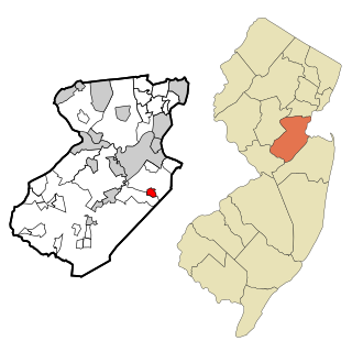
East Freehold is an unincorporated community and census-designated place (CDP) located within Freehold Township, in Monmouth County, in the U.S. state of New Jersey. As of the 2010 United States Census, the CDP's population was 4,894.

<span class="mw-page-title-main">North Boston, New York</span> Census-designated place in New York, United States

North Boston is a hamlet and census-designated place (CDP) in the town of Boston in Erie County, New York, United States. As of the 2010 census, the CDP population was 2,521. It is part of the Buffalo–Niagara Falls Metropolitan Statistical Area.

<span class="mw-page-title-main">Lake Katrine, New York</span> CDP in New York, United States

Lake Katrine is a hamlet in Ulster County, New York, United States. The population was 2,522 at the 2020 census.

<span class="mw-page-title-main">Shenorock, New York</span> CDP in New York, United States

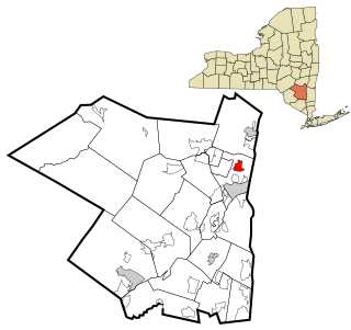
Shenorock is a hamlet and census-designated place (CDP) located in the town of Somers in Westchester County, New York, United States. The population was 1,898 at the 2010 census.

<span class="mw-page-title-main">Oak Hills, Pennsylvania</span> Census-designated place in Pennsylvania, United States

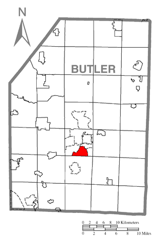
Oak Hills is a census-designated place (CDP) in Butler County, Pennsylvania, United States. The population was 2,333 at the 2010 census.

<span class="mw-page-title-main">Beaverdale, Pennsylvania</span> Census-designated place in Pennsylvania, United States

Beaverdale is an unincorporated community and census-designated place (CDP) in Cambria County, Pennsylvania, United States. The population was 1,035 at the 2010 census. Prior to that time, the CDP was known as Beaverdale-Lloydell.

<span class="mw-page-title-main">Lower Yoder Township, Cambria County, Pennsylvania</span> Township in Pennsylvania, United States

Lower Yoder Township is a township in Cambria County, Pennsylvania, United States. The population was 2,699 at the 2010 census, down from 3,029 at the 2000 census. It is part of the Johnstown, Pennsylvania Metropolitan Statistical Area.

<span class="mw-page-title-main">Salix, Pennsylvania</span> Census-designated place in Pennsylvania, United States

Salix is an unincorporated community and census-designated place (CDP) in Cambria County, Pennsylvania, United States. The population was 1,149 at the 2010 census. In previous censuses it was listed as Salix-Beauty Line Park.

<span class="mw-page-title-main">Vinco, Pennsylvania</span> Census-designated place in Pennsylvania, United States

Vinco is an unincorporated community and census-designated place (CDP) in Jackson Township, Cambria County, in the U.S. state of Pennsylvania. The population was 1,305 at the 2010 census.

<span class="mw-page-title-main">Republic, Pennsylvania</span> Census-designated place in Pennsylvania, United States

Republic is an unincorporated community and census-designated place (CDP) in Fayette County, Pennsylvania, United States. The population was 1,096 at the 2010 census, down from 1,396 at the 2000 census. The community is in Redstone Township.

Heilwood is a census-designated place (CDP) in Indiana County, Pennsylvania, United States. The population was 711 at the time of the 2010 census.

<span class="mw-page-title-main">Evansburg, Pennsylvania</span> Census-designated place in Pennsylvania, United States

Evansburg is a census-designated place (CDP) in Montgomery County, Pennsylvania, United States. The population was 2,129 at the 2010 census. It is a section of Lower Providence Township and is the namesake of Evansburg State Park.

<span class="mw-page-title-main">Pottsgrove, Pennsylvania</span> Census-designated place in Pennsylvania, United States

Pottsgrove is a census-designated place (CDP) in Montgomery County, Pennsylvania, United States. The population was 3,469 at the 2010 census.

<span class="mw-page-title-main">Spring House, Pennsylvania</span> Census-designated place in Pennsylvania, United States

Spring House is a census-designated place (CDP) in Lower Gwynedd Township, Montgomery County, Pennsylvania, United States. The population was 3,978 at the 2020 census.

<span class="mw-page-title-main">Brandonville, Pennsylvania</span> CDP in Pennsylvania, United States

Brandonville is a census-designated place (CDP) in East Union Township in Schuylkill County, Pennsylvania. The population was 180 at the 2020 census.

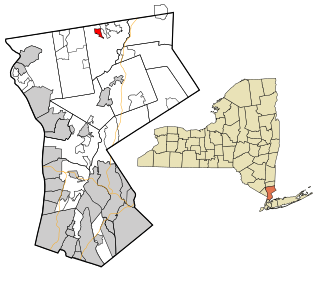
Yorkshire is a census-designated place (CDP) in the northeastern corner of the town of Yorkshire in Cattaraugus County, New York, United States. The population of the CDP was 1,180 at the 2010 census, out of 3,913 in the town of Yorkshire as a whole.

References

  1. "US Gazetteer files: 2010, 2000, and 1990". United States Census Bureau. February 12, 2011. Retrieved April 23, 2011.
  2. "U.S. Census website". United States Census Bureau . Retrieved January 31, 2008.