St. Xavier, Montana

Last updated

St. Xavier, Montana
Unincorporated community and census-designated place
St. Xavier, Montana (2014).jpg
St. Xavier in 2014
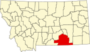
Big Horn County Montana Incorporated and Unincorporated areas St. Xavier Highlighted.svg
Location of St. Xavier, Montana
Coordinates: 45°27′40″N107°43′18″W / 45.46111°N 107.72167°W / 45.46111; -107.72167
Country United States
State Montana
County Big Horn
Area
[1]
  Total5.60 sq mi (14.49 km2)
  Land5.60 sq mi (14.49 km2)
  Water0.00 sq mi (0.00 km2)
Elevation
[2]
3,074 ft (937 m)
Population
 (2020)
  Total78
  Density13.94/sq mi (5.38/km2)
Time zone UTC-7 (Mountain (MST))
  Summer (DST) UTC-6 (MDT)
ZIP code
59075 [3]
Area code 406
FIPS code 30-65650
GNIS feature ID776137 [2] 2409234 [4]

St. Xavier is an unincorporated community and census-designated place (CDP) in Big Horn County, Montana, United States. [4] [2] The CDP population was 83 at the 2010 census. [5]

Contents

Geography

According to the United States Census Bureau, the CDP has a total area of 5.6 square miles (14.6 km2), of which 5.6 square miles (14.4 km2) is land and 0.077 square miles (0.2 km2), or 1.12%, is water. [5] It is located on the Crow Indian Reservation [6] along the Bighorn River.

Demographics

Historical population
CensusPop.Note
2020 78
U.S. Decennial Census [7]

As of the census [8] of 2000, there were 67 people, 20 households, and 18 families residing in the CDP. The population density was 12.0 people per square mile (4.6/km2). There were 36 housing units at an average density of 6.5 per square mile (2.5/km2). The racial makeup of the CDP was 38.81% White, 52.24% Native American, 7.46% from other races, and 1.49% from two or more races. Hispanic or Latino of any race were 22.39% of the population.

There were 20 households, out of which 55.0% had children under the age of 18 living with them, 70.0% were married couples living together, 15.0% had a female householder with no husband present, and 10.0% were non-families. 10.0% of all households were made up of individuals, and none had someone living alone who was 65 years of age or older. The average household size was 3.15 and the average family size was 3.33.

In the CDP, the population was spread out, with 32.8% under the age of 18, 13.4% from 18 to 24, 31.3% from 25 to 44, 16.4% from 45 to 64, and 6.0% who were 65 years of age or older. The median age was 28 years. For every 100 females, there were 67.5 males. For every 100 females age 18 and over, there were 95.7 males.

The median income for a household in the CDP was $19,722, and the median income for a family was $19,722. Males had a median income of $11,250 versus $15,500 for females. The per capita income for the CDP was $11,578. There were 25.0% of families and 40.7% of the population living below the poverty line, including 70.4% of under eighteens and none of those over 64.

Notable person

Related Research Articles

<span class="mw-page-title-main">Big Horn County, Montana</span> County in Montana, United States

Big Horn County is a county located in the U.S. state of Montana. As of the 2020 census, the population was 13,124. The county seat is Hardin. The county, like the river and the mountain range, is named after the bighorn sheep in the Rocky Mountains. The county was founded in 1913. It is located on the south line of the state.

<span class="mw-page-title-main">Busby, Montana</span> Census-designated place in Big Horn County, Montana, United States

Busby is a census-designated place (CDP) in Big Horn County, Montana, United States. It is on the Northern Cheyenne reservation. The population was 745 at the 2010 census.

<span class="mw-page-title-main">Pryor, Montana</span> Census-designated place in Montana, United States

Pryor is a census-designated place (CDP) in Big Horn County, Montana, United States. The community is located on Crow Tribe's reservation. The population was 618 at the 2010 census. The area is named for Nathaniel Hale Pryor, a sergeant in the Lewis and Clark Expedition.

<span class="mw-page-title-main">Wyola, Montana</span> Census-designated place in Montana, United States

Wyola is a census-designated place (CDP) in Big Horn County, Montana, United States. The population was 215 at the 2010 census. 79% of the residents are Native American, and the majority are members of the Crow Nation.

<span class="mw-page-title-main">Fort Belknap Agency, Montana</span> Census-designated place in Montana, United States

Fort Belknap Agency is a census-designated place (CDP) in Blaine County, Montana, United States. As of the 2010 census, its population was 1,293.

<span class="mw-page-title-main">Hays, Montana</span> Census-designated place in Montana, United States

Hays is a census-designated place (CDP) in Blaine County, Montana, United States. The population was 843 at the 2010 census. The community lies within the Fort Belknap Indian Reservation, near the reservation's southern end. The nearby community of Lodge Pole lies to the east.

<span class="mw-page-title-main">Boneau, Montana</span> Census-designated place in Montana, United States

Boneau is a census-designated place (CDP) in Chouteau County, Montana, United States. The population was 380 at the 2010 census, up from 190 in 2000.

<span class="mw-page-title-main">North Browning, Montana</span> Census-designated place in Montana, United States

North Browning is a census-designated place (CDP) in Glacier County, Montana, United States. The population was 2,408 at the 2010 census.

<span class="mw-page-title-main">South Browning, Montana</span> Census-designated place in Montana, United States

South Browning is a census-designated place (CDP) in Glacier County, Montana, United States. The population was 1,785 at the 2010 census. South Browning is a rural village on the Blackfeet Indian Reservation. It is bordered to the north by the town of Browning.

<span class="mw-page-title-main">Starr School, Montana</span> Census-designated place in Montana, United States

Starr School is a census-designated place (CDP) in Glacier County, Montana, United States. The population was 252 at the 2010 census.

<span class="mw-page-title-main">Elmo, Montana</span> Census-designated place in Montana, United States

Elmo is a census-designated place (CDP) in Lake County, Montana, United States. The population was 180 at the 2010 census, up from 143 in 2000.

<span class="mw-page-title-main">Evaro, Montana</span> CDP in Montana, United States

Evaro is a census-designated place (CDP) in Missoula County, Montana, United States, and part of the Missoula Metropolitan Statistical Area. It is located on the southernmost tip of the Flathead Indian Reservation, approximately 12 miles (19 km) north of downtown Missoula and is served by US Highway 93. In 2010, Evaro had a population of 322, a decrease from 329 in 2000.

<span class="mw-page-title-main">Heart Butte, Montana</span> Census–designated place in Pondera County, Montana

Heart Butte is a census-designated place (CDP) in Pondera County, Montana, United States. The population was 698 at the 2000 census. The town is on the Blackfeet Indian Reservation.

<span class="mw-page-title-main">Birney, Montana</span> Census-designated place in Montana, United States

Birney is a census-designated place (CDP) in Rosebud County, Montana, United States. The population was 108 at the 2000 census.

<span class="mw-page-title-main">Reserve, Montana</span> CDP in Montana, United States

Reserve is a census-designated place (CDP) in Sheridan County, Montana, United States. The population was 23 at the 2010 census.

<span class="mw-page-title-main">Absarokee, Montana</span> CDP in Montana, United States

Absarokee is a census-designated place (CDP) in Stillwater County, Montana, United States, approximately 14 miles (23 km) south of Columbus on Highway 78. It is named after the Crow Indians who formerly inhabited the land. The population was 1,234 at the 2000 census. The Stillwater Mine, operated by the Stillwater Mining Company, is located near Absarokee.

<span class="mw-page-title-main">Ballantine, Montana</span> CDP in Montana, United States

Ballantine is a census-designated place (CDP) in Yellowstone County, Montana, United States. It lies approximately nine miles (14 km) northeast of Billings on Interstate 94. The population was 346 at the 2000 census. Ballantine, along with the communities of Pompey's Pillar, Worden, and Huntley, is part of the Huntley Project, an irrigation district created by the United States Bureau of Reclamation. The majority of Ballantine's population lives on scattered farms and ranches surrounding the actual townsite.

<span class="mw-page-title-main">Huntley, Montana</span> CDP in Montana, United States

Huntley is a census-designated place (CDP) in Yellowstone County, Montana, United States. The population was 411 at the 2000 census. Huntley lent its name to the Huntley Project, a federal irrigation project that began delivering water to the arid district in 1907. Today, Huntley is an eastern suburb of Billings and is located east of Shepherd and west of Worden.

<span class="mw-page-title-main">Worden, Montana</span> CDP in Montana, United States

Worden is a census-designated place (CDP) in Yellowstone County, Montana, United States. The population was 506 at the 2000 census. Worden, along with Ballantine, Huntley, and Pompey's Pillar, is part of the Huntley Project, an irrigation district established by the United States Bureau of Reclamation in 1907.

<span class="mw-page-title-main">Niarada, Montana</span> Unincorporated community in Montana, United States

Niarada is a census-designated place (CDP) in Flathead and Sanders counties in Montana, United States. The population was 27 at the 2010 census, down from 50 in 2000.

References

  1. "ArcGIS REST Services Directory". United States Census Bureau. Retrieved September 5, 2022.
  2. 1 2 3 U.S. Geological Survey Geographic Names Information System: St. Xavier, Montana
  3. "Saint Xavier ZIP Code". zipdatamaps.com. 2022. Retrieved November 11, 2022.
  4. 1 2 U.S. Geological Survey Geographic Names Information System: Saint Xavier Census Designated Place
  5. 1 2 "Geographic Identifiers: 2010 Demographic Profile Data (G001): St. Xavier CDP, Montana". U.S. Census Bureau, American Factfinder. Archived from the original on February 12, 2020. Retrieved June 25, 2013.
  6. US Census, 2020 CENSUS - TRIBAL TRACT MAP: Crow Reservation and Off-Reservation Trust Land Link
  7. "Census of Population and Housing". Census.gov. Retrieved June 4, 2016.
  8. "U.S. Census website". United States Census Bureau . Retrieved January 31, 2008.