St Bartholomew's Anglican Church and Cemetery, Prospect

Last updated

St Bartholomew's Anglican Church (former) and Cemetery
St Bartholomew's Anglican Church (former)
ProspectNSWStBarts.jpg
The former St Bartholomew's Anglican Church, pictured in 2009
Location map Australia Sydney.png
Red pog.svg
St Bartholomew's Anglican Church (former) and Cemetery
33°48′16″S150°55′03″E / 33.8045°S 150.9176°E / -33.8045; 150.9176
LocationPonds Road, Prospect, City of Blacktown, New South Wales
CountryAustralia
Denomination Anglican
Website stbartholomewsprospect.org/FOSBchurch.html
History
Status Church
Dedication Saint Bartholomew
Consecrated 1841 (1841)
Associated people
Architecture
Functional statusPreserved
Architect(s) Henry Robertson
Architectural typeChurch
Style Victorian Georgian
Years built1838–1840
Construction cost 1,250
Closed24 December 1967 (1967-12-24)
Specifications
Materials
  • Brick
  • Corrugated iron
  • Cedar joinery
Official nameSt. Bartholomew's Anglican Church (former) & Cemetery; Bartholomew's Anglican Church & Cemetery; St Bartholomew's Anglican Church
TypeState heritage (complex / group)
Designated2 April 1999
Reference no.37
TypeChurch
CategoryReligion
BuildersJames Atkinson

St Bartholomew's Anglican Church and Cemetery is a heritage-listed former Anglican church and cemetery at Ponds Road, Prospect, City of Blacktown, New South Wales, Australia. It was designed by Henry Robertson and built from 1838 to 1840 by James Atkinson. It was added to the New South Wales State Heritage Register on 2 April 1999. [1] Since 1975, the site has been leased to the Council of the City of Blacktown.

Contents

History

Aboriginal and European settler history

The area of Prospect Reservoir is an area of known Aboriginal occupation, with favourable camping locations along the Eastern Creek and Prospect Creek catchments, and in elevated landscapes to the south. There is also evidence to suggest that the occupation of these lands continued after European contact, through discovery of intermingled glass and stone flakes in archaeological surveys of the place. The area was settled by Europeans by 1789. [1]

Prospect Hill, Sydney's largest body of igneous rock, lies centrally in the Cumberland Plain and dominates the landscape of the area. Very early after first settlement, on 26 April 1788, an exploration party heading west led by Governor Phillip, climbed Prospect Hill. An account by Phillip states that the exploration party saw from Prospect Hill, "for the first time since we landed Carmathen [sic] Hills (Blue Mountains) as likewise the hills to the southward". Phillip's "Bellevue" (Prospect Hill) acquired considerable significance for the new settlers. Prospect Hill provided a point from which distances could be meaningfully calculated, and became a major reference point for other early explorers. When Watkin Tench made another official journey to the west in 1789, he began his journey with reference to Prospect Hill, which commanded a view of the great chain of mountains to the west. A runaway convict, George Bruce, used Prospect Hill as a hideaway from soldiers in the mid-1790s. [1]

During the initial struggling years of European settlement in NSW, Governor Phillip began to settle time-expired convicts on the land as farmers, after the success of James Ruse at Rose Hill. On 18 July 1791 Phillip placed a number of men on the eastern and southern slopes of Prospect Hill, as the soils weathered from the basalt cap were richer than the sandstone derived soils of the Cumberland Plain. The grants, mostly 30 acres, encircled Prospect Hill. The settlers included William Butler, James Castle, Samuel Griffiths, John Herbert, George Lisk, Joseph Morley, John Nicols, William Parish and Edward Pugh. [1]

The arrival of the first settlers prompted the first organised Aboriginal resistance to the spread of settlement, with the commencement of a violent frontier conflict in which Pemulwuy and his Bidjigal clan played a central role. On 1 May 1801 Governor King took drastic action, issuing a public order requiring that Aboriginal people around Parramatta, Prospect Hill and Georges River should be "driven back from the settlers" habitations by firing at them'. King's edicts appear to have encouraged a shoot-on-sight attitude whenever any Aboriginal men, women or children appeared. [1]

With the death of Pemulwuy, the main resistance leader, in 1802, Aboriginal resistance gradually diminished near Parramatta, although outer areas were still subject to armed hostilities. Prompted by suggestions to the Reverend Marsden by local Prospect Aboriginal groups that a conference should take place "with a view of opening the way to reconciliation", Marsden promptly organised a meeting near Prospect Hill. At the meeting, held on 3 May 1805, local Aboriginal representatives discussed with Marsden ways of ending the restrictions and indiscriminate reprisals inflicted on them by soldiers and settlers in response to atrocities committed by other Aboriginal clans. The meeting was significant because a group of Aboriginal women and a young free settler at Prospect named John Kennedy acted as intermediaries. The conference led to the end of the conflict for the Aboriginal clans around Parramatta and Prospect. This conference at Prospect on Friday 3 May 1805 is a landmark in Aboriginal/European relations. Macquarie's "Native Feasts" held at Parramatta from 1814 followed the precedent set in 1805. The Sydney Gazette report of the meeting is notable for the absence of the sneering tone that characterised its earlier coverage of Aboriginal matters. [1]

From its commencement in 1791 with the early settlement of the area, agricultural use of the land continued at Prospect Hill. Much of the land appears to have been cleared by the 1820s and pastoral use of the land was well established by then. When Governor Macquarie paid a visit to the area in 1810, he was favourably impressed by the comfortable conditions that had been created. [1]

Nelson Lawson, third son of explorer William Lawson (1774–1850), married Honoria Mary Dickinson and before 1837 built "Greystanes House" as their future family home on the western side of Prospect Hill. Lawson had received the land from his father, who had been granted 202 hectares (500 acres) here by the illegal government that followed the overthrow of Governor Bligh in 1808. [1]

Governor Macquarie confirmed the grant, where William Lawson had built a house, which he called "Veteran Hall", because he had a commission in the NSW Veterans Company. The house was demolished in 1928 and the site is now partly covered by the waters of Prospect Reservoir. Greystanes was approached by a long drive lined with an avenue of English trees – elms (Ulmus procera), hawthorns ( Crataegus sp.), holly ( Ilex aquifolium ), and woodbine ( Clematis sp.) mingling with jacarandas ( Jacaranda mimosifolia ). It had a wide, semi-circular front verandah supported by four pillars. The foundations were of stone, the roof of slate, and the doors and architraves of heavy red cedar. It was richly furnished with articles of the best quality available and was the scene of many glittering soirees attended by the elite of the colony. Honoria Lawson died in 1845, Nelson remarried a year later, but died in 1849, and the property reverted to his father. Greystanes house was demolished in the 1940s. [2] [1]

By the 1870s, with the collapse of the production of cereal grains across the Cumberland Plain, the Prospect Hill area appears to have largely been devoted to livestock. The dwellings of the earliest settlers largely appear to have been removed by this stage. By the time that any mapping was undertaken in this vicinity, most of these structures had disappeared, making their locations difficult to pinpoint. [1]

The land was farmed from 1806 to 1888 when the Prospect Reservoir was built. In 1867, the Governor of New South Wales appointed a Commission to recommend a scheme for Sydney's water supply, and by 1869 it was recommended that construction commence on the Upper Nepean Scheme. This consisted of two diversion weirs, located at Pheasant's Nest and Broughton's Pass, in the Upper Nepean River catchment, with water feeding into a series of tunnels, canals and aqueducts known as the Upper Canal. It was intended that water be fed by gravity from the catchment into a reservoir at Prospect. This scheme was to be Sydney's fourth water supply system, following the Tank Stream, Busby's Bore and the Botany (Lachlan) Swamps. [1] Designed and constructed by the NSW Public Works Department, Prospect Reservoir was built during the 1880s and completed in 1888. Credit for the Upper Nepean Scheme is largely given to Edward Orpen Moriarty, the Engineer in Chief of the Harbours and Rivers Branch of the Public Works Department from 1858 to 1888. [1]

St. Bartholemew's Church

Prior to 1836 the building of churches in New South Wales had been a haphazard responsibility of the government. In 1836 the Church Act came into force to promote the building of churches and chapels and provide for the maintenance of Ministers of Religion. The Act immediately led to a spate of church building. [1] St. Bartholemew's Church of England was built by pioneers of Prospect with funds collected from 1837. [1]

In August 1838 tenders were called for the construction of St Bartholomew's Church. The contract was won by James Atkinson of Mulgoa who was building three other churches at the same time: St Peter's at Richmond, St Mary Magdalene at St Mary's and St Thomas' at Mulgoa. His contract was with the trustees, William Lawson, Robert Crawford and Nelson Simmons Lawson. The original contract sum for the building was 1,250, half of which was borne by private subscription and half by the Colonial Treasury. Henry Robertson is thought to have been the architect for the building although it is highly possible that William Lawson, a surveyor by training, was designer of the church. [1] [3] :2–3

Grave of William Lawson, St Bartholomew's Churchyard Grave of William Lawson St. Bartholomew's Churchyard Prospect (10338475133).jpg
Grave of William Lawson, St Bartholomew's Churchyard

Lawson (1774–1850) who crossed the Blue Mountains with Gregory Blaxland and William Wentworth in 1813, lived in a house in Prospect called Veteran Hall (Lawson was a lieutenant in the NSW Veterans' Company, hence the name). Built in 1810 as a small cottage, it was extended to a forty-room mansion in 1822. Lawson's descendants continued to improve the house until the 1880s. It was demolished in 1926 and its site is now within the Prospect Reservoir grounds. Lawson married Sarah Leadbeater on Norfolk Island while serving there and they had 11 children between 1803 and 1826. William Lawson was buried on 16 June 1850. One of their daughters, Sophia, was born at Prospect, and when she died in 1906, was the last surviving child. The family vault at St. Bartholemew's shelters the remains of several members of this large family. [1]

In April/May 1841 the church and cemetery were consecrated. The earliest burials, on 18 July 1841, were Ann and Margaret Goodin, the 25 and 9 year old daughters of early settlers James and Ann Goodin. The first minutes of the vestry meeting are dated 1842 and refer to the opening of the parish registers by the Rev. H. H. Bobart, who was the rector of St. John's, Parramatta. [1]

By 1891 over 360 burials had been recorded in the Parish Register. From the turn of the century to 1941 there was a substantial increase in the annual number of burials, reflecting the development of the district with the subdivision of farms into suburban allotments, the encroaching metropolitan area and the industrial development with the development of metal quarries, saw mills, brick and tile works and Bonds cotton spinning mills. Burials are now only permitted in previously purchased plots, the sale of which were discontinued in 1992 and in existing graves where there is space. Two burials are permitted in most plots. [1] [4] :15–16

The condition of the church deteriorated throughout the mid-twentieth century, and a dwindling congregation and lack of financial support led to its closure in 1967. [5] The last service was held on Christmas Eve that year. A group of citizens interested in preserving the church formed The Prospect Trust in November 1967 under the chairmanship of Robert Brown. In late 1969 the City of Blacktown commenced negotiations with the Church of England Property Trust. A fifty-year lease over most of the property was obtained by Council in 1975. [1]

In 1978 $20,000 was made available from National Estate Funds towards restoration provided the funds be administered by the National Trust of Australia. [1]

In 1982 a Permanent Conservation order was placed on the site. A further $100,000 were allocated for restoration by the Minister for Public Works subject to Blacktown Council meeting this amount on a dollar for dollar basis. Blacktown Council requested the Minister's offer be deferred until Council had negotiated the leasing arrangement into purchase of the building by them or the Department of Environment and Planning. [1]

Fire destroyed much of the contents of the church and severely damaged the roof in November 1989. Parts of the original box pews and joinery, an 1850s organ brought to St Bartholomew's in 1888, a pulpit and lecterns from 1908 and all pressed metal ceilings were lost. In 1991 work commenced to repair the roof and brickwork damaged by the fire. [1] [3] :3–4 From 2000 to 2001 the Church was completely restored, including interiors and windows with the use of Centenary of Federation funding. [1] The restoration received an EnergyAustralia National Trust Heritage Award in 2004. [1]

In October 2015, the state government gave the City of Blacktown a 52,000-square-metre (560,000 sq ft) parcel of land surrounding the cemetery, allowing the council to proceed with plans to extend the cemetery to meet the needs of the area's growing population. [6] As of June 2018, this has not yet taken place, with the Council continuing to advertise that no new burial licenses can be purchased, with burials only able to take place where rights were purchased prior to 1992. [7]

Modifications and dates

Description

Site

St Bartholomew's stands on the hill for which the district is famous – Prospect Hill. It is a conspicuous landmark from which there are fine views from to the Blue Mountains and the City of Sydney. Several mature trees including Mediterranean cypress ( Cupressus sempervirens ), arborvitae ( Thuja species), coral trees ( Erythrina species, possibly E.indica), Moreton Bay figs ( Ficus macrophylla ), gums ( Eucalyptus spp.), and Bunya pine ( Araucaria bidwillii ), and African olive (Olea europaea var.africana) clumps are found alongside the fence at either side of the entrance gates to the church. Remnants of early post and rail fencing and entrance gateposts are also found. Lower plantings include variegated century plant ( Agave americana Variegata). [8] [1]

The church is surrounded by a graveyard laid out in a grid pattern. It contains sandstone headstones and columns and small headstones in marble and granite, many originally bordered by cast iron surrounds. [1]

Church

The building is a plain, rectangular brick structure in the Victorian Georgian style, built on an east–west axis comprising nave, chancel and vestries with a tower at the west end. The tower has a square base with an octagonal belfry. The belfry roof timbers carry a timber bell supporting frame although no bell is in place. The roof over the chancel and vestries is separate from the main roof over the nave. The entrance to the building is through the tower. There are also entrances to the vestries from the exterior. [1]

The external walls are modelled by flat pilasters and finely moulded stone entablatures carried on carved stone modillion brackets, rectangular openings and blind windows. The hipped roof, originally shingled, is now clad with corrugated steel. [1]

The interior joinery was finely moulded cedar and the interior walls plastered and painted. Each vestry had a fireplace but the chimneys and mantelpieces have now been removed. The floors are timber. The chancel floor, originally one step above the main floor, has been raised further and a rectangular projecting dais into the main hall added. There is also a small dais in the north western corner of the church on which a font was once placed. [1]

Church Hall

The church hall, relocated from its original location in Wetherill Park in 1908, is a one-storey, rectangular building. The exterior walls are corrugated iron over timber framing and the interior walls are timber boarded. The roof is corrugated steel over timber rafters with metal rods. The hall is on a brick base and may have been a prefabricated building. [1] [3] :5–6

Condition

The physical condition of the site was reported to be good to excellent as at 9 August 2005. [1]

Some elements have been removed for their protection and preservation. There are some problems involved in reinstating them. [1]

Heritage listing

The St Bartholomew's site is closely linked with the development and history of the surrounding area and contains the graves of a considerable number of prominent families from the area since the 1840s. The church is unusually styled for its period and the graveyard is one of the earliest in western Sydney. St. Bartholomew's remains a dominant landmark in the surrounding landscape due to its prominent siting, striking design and mature tree plantings. [1] [3] :8 [4] :100

St Bartholomew's Anglican Church & Cemetery was listed on the New South Wales State Heritage Register on 2 April 1999 having satisfied the following criteria. [1]

The place is important in demonstrating the course, or pattern, of cultural or natural history in New South Wales.

The cemetery contains the graves of a number of prominent families and individuals from the founders of the community, including the Lawsons of Veteran Hall (Blaxland, Lawson and Wentworth) and the Westons, through to the more recent sporting fame of the Heckenbergs. It demonstrates important family lineages across its entire site from the earliest settlers to their more recent descendants, such as the Leabon and Pond families. [1] [4] :100

The church is an unusually detailed and planned church. The division of the east end into three separately roofed compartments may be the only extant example in NSW of this design. It therefore occupies a special position in the architectural evolution of churches in NSW. [1]

The church hall provides an element associated with the construction of Prospect Reservoir, a major engineering achievement within the district. [1] [3] :8

The place is important in demonstrating aesthetic characteristics and/or a high degree of creative or technical achievement in New South Wales.

The site is an important surviving fragment of nineteenth century cultural landscape; an historic icon; a virtual oasis, and de facto public heritage green space, in a once notable rural area now surrounded by the effects of rapid urban, industrial and commercial development. It reflects a visual continuity between 19th and 20th century society. This may be seen not only in the chronological continuity of family burials, but also dramatically in the direct accommodation of power transmission towers, the F4 tollway, the modern Great Western Highway route and the first Great Western Highway route. [1] [4] :100

The place has a strong or special association with a particular community or cultural group in New South Wales for social, cultural or spiritual reasons.

The church is a building closely linked with the development and early history of the district. [1] [3] :8

The place has potential to yield information that will contribute to an understanding of the cultural or natural history of New South Wales.

The church is an extant example of an 1840s church, providing evidence of the Church Act. [1] [3] :8

See also

Related Research Articles

<span class="mw-page-title-main">Greater Western Sydney</span> Region in New South Wales, Australia

Greater Western Sydney (GWS) is a large region of the metropolitan area of Greater Sydney, New South Wales (NSW), Australia that generally embraces the north-west, south-west, central-west, far western and the Blue Mountains sub-regions within Sydney's metropolitan area and encompasses 13 local government areas: Blacktown, Blue Mountains, Camden, Campbelltown, Canterbury-Bankstown, Cumberland, Fairfield, Hawkesbury, Hills Shire, Liverpool, Parramatta, Penrith and Wollondilly. It includes Western Sydney, which has a number of different definitions, although the one consistently used is the region composed of ten local government authorities, most of which are members of the Western Sydney Regional Organisation of Councils (WSROC). Penrith, Hills Shire & Canterbury-Bankstown are not WSROC members. The NSW Government's Office of Western Sydney calls the region "Greater Western Sydney".

<span class="mw-page-title-main">Seven Hills, New South Wales</span> Suburb of Sydney, New South Wales, Australia

Seven Hills is a suburb in the Greater Western Sydney region of Sydney, in the state of New South Wales, Australia, located 33 kilometres North West of the Sydney central business district. Seven Hills is within the local government areas of the City of Parramatta and Blacktown City councils.

<span class="mw-page-title-main">Prospect, New South Wales</span> Suburb of Sydney, New South Wales, Australia

Prospect is a suburb of Sydney, in the state of New South Wales, Australia. Prospect is located 32 kilometres west of the Sydney central business district in the local government area of the City of Blacktown and a small part of Cumberland City Council, is part of the Greater Western Sydney region. One of the oldest suburbs in Sydney, Prospect takes its name from the prominent nearby landmark of Prospect Hill - from the top of which people could get a prospect of the surrounding countryside.

<span class="mw-page-title-main">Blacktown City Council</span> Local government area in New South Wales, Australia

Blacktown City Council is a local government area in Western Sydney, situated on the Cumberland Plain, approximately 35 kilometres (22 mi) west of the Sydney central business district, in the state of New South Wales, Australia. Established in 1906 as the Blacktown Shire and becoming the Municipality of Blacktown in 1961 before gaining city status in 1979, the City occupies an area of 246.9 square kilometres (95.3 sq mi) and has a population of 410,419, making it the most populous local government area in Sydney.

<span class="mw-page-title-main">Prospect Hill (New South Wales)</span>

Prospect Hill is a heritage-listed hill in Pemulwuy and Prospect in the greater western region of Sydney, New South Wales, Australia. Situated about 30 kilometres west of central Sydney, the hill is Sydney's largest body of igneous rock and is higher than the ridges of the Cumberland Plain around it, with its present-day highest point being 117 metres high, although before its summit was quarried away it rose to a height of 131 metres above sea level.

<span class="mw-page-title-main">St John's Cathedral, Parramatta</span> Church in New South Wales, Australia

St John's Cathedral is a heritage-listed, Anglican cathedral in Parramatta, City of Parramatta, Sydney, New South Wales, Australia. St John's was given the status of provisional cathedral of the Anglican Diocese of Sydney in 1969, and designated a Regional Cathedral in 2011 for the Western Region. It was added to the New South Wales State Heritage Register on 5 March 2010.

<span class="mw-page-title-main">St Jude's Church, Randwick</span> Church in New South Wales, Australia

The St Jude's Church is an active Anglican church in Randwick, a suburb of Sydney, New South Wales, Australia. It is part of a significant heritage group that includes the church, cemetery, rectory and original Randwick Borough Chambers, later converted to church use. The group is located on Avoca Street, Randwick, and has a federal heritage listing. It was added to the New South Wales State Heritage Register on 2 April 1999.

<span class="mw-page-title-main">St Peters Church, St Peters</span> Church in St Peters, Sydney, Australia

St Peter's Anglican Church is a heritage-listed Anglican church located at 187-209 Princes Highway, St Peters, in Sydney, New South Wales, Australia. It is one of the oldest churches in Sydney. Designed by Thomas Bird, the church is sometimes referred to as St Peter's Church, Cooks River, as it is located in the Anglican Parish of Cooks River, New South Wales. The church is listed on the NSW State Heritage Register and on the Register of the National Estate.

<span class="mw-page-title-main">Old St Mark's Anglican Church, Slacks Creek</span> Historic site in Queensland, Australia

Old St Mark's Anglican Church is a heritage-listed former church and current church hall at 2 Boronia Drive and 41A Winnetts Road, Daisy Hill, City of Logan, Queensland, Australia. It was built in 1901 by W Anthony. It was known as St Mark's Anglican Church. It was added to the Queensland Heritage Register on 30 March 2001.

Maria Lock was an Aboriginal Australian landowner in the Darug area of Western Sydney. Lock is significant in Australian history due to her educational achievements, having the first legally recognised marriage between a settler and an Aboriginal person, and later for being a landowner in early colonial times. She is also known as Maria Locke.

<span class="mw-page-title-main">Holy Trinity Anglican Church, Kelso</span> Heritage listed Church in New South Wales, Australia

Holy Trinity Anglican Church is a heritage-listed Anglican church precinct, containing the church, rectory and adjacent cemetery, at 71-85 Gilmour Street, Kelso, Bathurst Region, New South Wales, Australia. The church was built from 1833 to 1878, with John Foster being responsible for the building of the original church. Edmund Blacket designed the rectory. The property is owned by Anglican Property Trust Diocese of Bathurst and Parish of Kelso, Anglican Diocese of Bathurst. It was added to the New South Wales State Heritage Register on 14 January 2011.

<span class="mw-page-title-main">St Andrew's Anglican Church, Seven Hills</span> Church in New South Wales, Australia

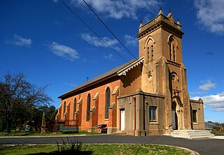
St Andrew's Anglican Church is a heritage-listed former Anglican church complex and now private residence at 313 Seven Hills Road, Seven Hills, City of Blacktown, Sydney, New South Wales, Australia. It was designed by G. H. Stoker, and built by Stoker from 1863 to 1892. It is also known as St. Andrew's Anglican Church, Hall & Rectory, St Andrew's and St Andrews. The property is privately owned. It was added to the New South Wales State Heritage Register on 2 April 1999.

<span class="mw-page-title-main">Former Great Western Road Alignment, Prospect</span> Historic road in New South Wales, Australia

Former Great Western Road Alignment, Prospect is a heritage-listed stretch of road, now divided into four separately-named sections of road and partially divided by the M4 Western Motorway at, Prospect, City of Blacktown, Sydney, New South Wales, Australia. The road was initiated by Governor Lachlan Macquarie, likely surveyed by George Evans and built from 1815 to 1818 by William Cox. It is also known as The Western Road, The Great Western Road, The Old Western Road and The Great Western Highway. The property is owned by Blacktown City Council. It was added to the New South Wales State Heritage Register on 27 June 2014.

<span class="mw-page-title-main">Prospect Post Office</span> Historic site in New South Wales, Australia

Prospect Post Office is a heritage-listed former post office and shop at 23 Tarlington Place, Prospect, City of Blacktown, New South Wales, Australia. It was designed by James Watts and built by Watts from 1880 to 1890. The property is owned by the City of Blacktown. It was added to the New South Wales State Heritage Register on 2 April 1999.

<span class="mw-page-title-main">Royal Cricketers Arms Inn</span> Historic site in New South Wales, Australia

Royal Cricketers Arms Inn is a heritage-listed Australian pub at 385 Reservoir Road, Prospect, City of Blacktown, New South Wales, Australia. It was designed by James Manning and built by James Manning. It is also known as Cricketers Arms Inn. It was added to the New South Wales State Heritage Register on 2 April 1999.

<span class="mw-page-title-main">Veteran Hall Remains</span> Historic site in New South Wales, Australia

The Veteran Hall Remains are the heritage-listed archaeological remains of the former Veteran Hall house at Great Western Highway, Prospect, City of Blacktown, New South Wales, Australia. Veteran Hall was built in 1821 by William Lawson. The property is owned by Sydney Water. It was added to the New South Wales State Heritage Register on 18 November 1999.

<span class="mw-page-title-main">Prospect Reservoir Valve House</span> Historic site in New South Wales, Australia

The Prospect Reservoir Valve House is a heritage-listed waterworks located at East of Reservoir, Prospect in the City of Blacktown local government area of New South Wales, Australia. Situated on the grounds of Prospect Nature Reserve, it was designed and built by The Metropolitan Board of Water Supply and Sewerage. The property is owned by Sydney Water and Water NSW, agencies of the Government of New South Wales. It was added to the New South Wales State Heritage Register on 18 November 1999.

<span class="mw-page-title-main">St John's Anglican Church and Macquarie Schoolhouse</span> Church in New South Wales, Australia

St John's Anglican Church and Macquarie Schoolhouse is a heritage-listed Anglican church building and church hall located at 43-43a Macquarie Road, Wilberforce, City of Hawkesbury, New South Wales, Australia. The church was designed by Edmund Blacket and built from 1819 to 1859 by James Atkinson, senior; and the schoolhouse was built by John Brabyn. The church is also known as the St. John's (Blacket) Church, while the hall is also known as the Macquarie Schoolhouse/Chapel and the Wilberforce Schoolhouse. It was added to the New South Wales State Heritage Register on 20 August 2010.

<span class="mw-page-title-main">Prospect Nature Reserve</span>

Prospect Nature Reserve is a nature reserve and recreational area that is situated in the western suburbs of Sydney, New South Wales, Australia, which incorporates the Prospect Reservoir, and also features picnic spots, lookouts, walking tracks and BBQ areas within the Australian bush. It is located within the Blacktown City local government area, but is also close to the boundaries of Cumberland Council and the City of Fairfield.

<span class="mw-page-title-main">St Peter's Anglican Church, Richmond</span> Church in New South Wales, Australia (ty for the article whoever did it)

St Peter's Anglican Church is a heritage-listed Anglican church and associated Sunday school, rectory, and cemetery at 384 Windsor Street, Richmond, City of Hawkesbury, New South Wales, Australia. It was designed by Francis Clarke and Edmund Blacket and built from 1836 to 1841 by James Atkinson (church). It is also known as St Peter's Anglican Church Group, St Peter's Church Group, Church, Rectory, Church Yard, Cemetery and Stables. It was added to the New South Wales State Heritage Register on 16 August 2019; and on the City of Hawkesbury local government heritage register, and listed on the New South Wales Heritage Database on 12 September 2012.

References

  1. 1 2 3 4 5 6 7 8 9 10 11 12 13 14 15 16 17 18 19 20 21 22 23 24 25 26 27 28 29 30 31 32 33 34 35 36 37 38 39 40 41 "St. Bartholomew's Anglican Church (former) & Cemetery". New South Wales State Heritage Register . Department of Planning & Environment. H00037. Retrieved 1 June 2018. CC BY icon.svg Text is licensed by State of New South Wales (Department of Planning and Environment) under CC-BY 4.0 licence .
  2. Pollon, 1988, 116, amended Read, S., 2006 – "The house can't have been "on the crest" of Prospect Hill as Pollon states, if its site was covered by the Reservoir."
  3. 1 2 3 4 5 6 7 8 Historic Buildings Group, 1991
  4. 1 2 3 4 Heritage Group, 1994
  5. Buena, Pamela. "The Postmodern Ghost Tour". UTS ePress. Retrieved 18 June 2018.
  6. "St Bartholomew's Prospect cemetery given expansion green light after State Government land transfer". Blacktown Advocate. 13 October 2015. Retrieved 18 June 2018.
  7. "St Bartholomew's Cemetery". City of Blacktown. Retrieved 18 June 2018.
  8. Plant notes by Stuart Read, 2002

Bibliography

Attribution

CC BY icon-80x15.png This Wikipedia article was originally based on St. Bartholomew's Anglican Church (former) & Cemetery , entry number 00037 in the New South Wales State Heritage Register published by the State of New South Wales (Department of Planning and Environment) 2018 under CC-BY 4.0 licence , accessed on 1 June 2018.

Commons-logo.svg Media related to St Bartholomew's Anglican Church and Cemetery, Prospect at Wikimedia Commons