Staffelegg Formation

Last updated
Staffelegg Formation
Stratigraphic range: late Hettangian-early Toarcian
~200–182  Ma
ETH-BIB-Staffelegg, Jura-Profil von Suden, Schellenbrucke -Asperchlus--Dia 247-14394.tif
Outcrop of the formation in the Schellen quarry
Type Geological formation
Sub-units See text
Underlies Opalinus Clay
Overlies Keuper Group
Thickness20 to 50 m (66 to 164 ft)
Lithology
Primary Siltstone, marl
Other Limestone, sandstone
Location
Coordinates 47°24′N8°36′E / 47.4°N 8.6°E / 47.4; 8.6
Approximate paleocoordinates 36°54′N17°24′E / 36.9°N 17.4°E / 36.9; 17.4
Region Canton of Aargau
CountryFlag of Switzerland (Pantone).svg   Switzerland
Extent Folded Jura
Type section
Named for Staffelegg Pass
Named byReisdorf et al.
Location Staffelegg
Year defined2011
Switzerland relief location map.jpg
Blue pog.svg
Staffelegg Formation (Switzerland)

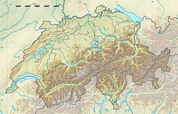
The Staffelegg Formation (German: Staffelegg-Formation, French: Formation de la Staffelegg, Italian: Formazione della Staffelegg) is a formation of Early Jurassic age (late Hettangian to early Toarcian stages) in the Canton of Aargau of northern Switzerland. The siltstones, marls, limestones and intermittent sandstones of the formation were deposited on the Northern Tethyan Carbonate Platform (NTCP). The Staffelegg Formation has provided fossils of the ichthyosaur Eurhinosaurus longirostris and the ammonite Catacoeloceras raquinianum .
Contents

Description

The formation is found in the northern canton of Aargau of Switzerland and has a thickness of 20 to 50 metres (66 to 164 ft), and in the Mont Terri area approximately 70 metres (230 ft). The Staffelegg Formation is named after the Staffelegg Pass, overlies the Keuper Group and is overlain by the Opalinus Clay. The formation comprises siltstones and marls. Additionally, limestones and subordinately also sandstones may occur especially in the Sinemurian part. In the Folded Jura, these sediments may make up the major portion of the Staffelegg Formation. Facies changes may occur within short distances in the Folded Jura. The Staffelegg Formation displays a small thickness compared to the occurrences of the Early Jurassic of southeastern France and southwestern Germany. A gradual decrease in thickness can be detected which continues from southwestern Germany into northern Switzerland. [1]

Formerly, the formation was considered part of the Posidonia Shale, until it was defined as a separate formation by Reisdorf et al. in 2011. [1] [2]

The formation was deposited on the Northern Tethyan Carbonate Platform. The Staffelegg Formation dates from the late Hettangian to early Toarcian. [1]

Subdivision

The Staffelegg Formation is subdivided into: [1]

  • Gross Wolf Member
  • Rietheim Member
  • Rickenbach Member
  • Breitenmatt Member
  • Grünschholz Member
  • Frick Member
  • Fasiswald Member
  • Membre du Mont Terri
  • Weissenstein Member
  • Beggingen Member
  • Schambelen Member

Fossil content

Among others, the following fossils have been reported from the formation: [3]

Reptiles

Life restoration of Eurhinosaurus Eurhinosaurus BW.jpg
Life restoration of Eurhinosaurus
Ichthyosaurs

Invertebrates

Ammonites

Related Research Articles

<span class="mw-page-title-main">Jurassic</span> Second period of the Mesozoic Era 201-145 million years ago

The Jurassic is a geologic period and stratigraphic system that spanned from the end of the Triassic Period 201.4 million years ago (Mya) to the beginning of the Cretaceous Period, approximately 145 Mya. The Jurassic constitutes the middle period of the Mesozoic Era and is named after the Jura Mountains, where limestone strata from the period were first identified.

<span class="mw-page-title-main">Early Jurassic</span> First epoch of the Jurassic Period

The Early Jurassic Epoch is the earliest of three epochs of the Jurassic Period. The Early Jurassic starts immediately after the Triassic–Jurassic extinction event, 201.3 Ma, and ends at the start of the Middle Jurassic 174.7 ±0.8 Ma.

<i>Temnodontosaurus</i> Extinct genus of reptiles

Temnodontosaurus is an extinct genus of ichthyosaur from the Early Jurassic period. They lived between 200 and 175 million years ago (Hettangian-Toarcian) in what is now Western Europe and possibly other countries including Switzerland and Chile. It lived in the deeper areas of the open ocean. University of Bristol paleontologist Jeremy Martin described the genus Temnodontosaurus as "one of the most ecologically disparate genera of ichthyosaurs," although the number of valid Temnodontosaurus species has varied over the years.

<i>Eurhinosaurus</i> Genus of leptonectid ichthyosaur from the Early Jurassic period

Eurhinosaurus is an extinct genus of ichthyosaur from the Early Jurassic (Toarcian), ranging between 183 and 175 million years. Fossils of the aquatic reptile have been found in Western Europe. They used to live in the deep, open sea area. Eurhinosaurus was a large genus of ichthyosaurs. An adult individual could reach up to 7 metres (23 ft) in length.

<span class="mw-page-title-main">Blue Anchor to Lilstock Coast SSSI</span>

Blue Anchor to Lilstock Coast SSSI is a 742.8 hectare geological Site of Special Scientific Interest between Blue Anchor and Lilstock in Somerset, notified in 1971.

<i>Palaeocoma</i> Extinct genus of brittle stars

Palaeocoma is an extinct genus of brittle stars that lived during the Middle Triassic to Early Jurassic Periods. Its fossils have been found in Europe.

<span class="mw-page-title-main">Blue Lias</span> Triassic/Jurassic geological formation in the UK

The Blue Lias is a geological formation in southern, eastern and western England and parts of South Wales, part of the Lias Group. The Blue Lias consists of a sequence of limestone and shale layers, laid down in latest Triassic and early Jurassic times, between 195 and 200 million years ago. The Blue Lias is famous for its fossils, especially ammonites.

The Aquitaine Basin is the second largest Mesozoic and Cenozoic sedimentary basin in France after the Paris Basin, occupying a large part of the country's southwestern quadrant. Its surface area covers 66,000 km2 onshore. It formed on Variscan basement which was peneplained during the Permian and then started subsiding in the early Triassic. The basement is covered in the Parentis Basin and in the Subpyrenean Basin—both sub-basins of the main Aquitaine Basin—by 11,000 m of sediment.

<span class="mw-page-title-main">Fernie Formation</span> Stratigraphic Unit in Western Canada

The Fernie Formation is a stratigraphic unit of Jurassic age. It is present in the western part of the Western Canada Sedimentary Basin in western Alberta and northeastern British Columbia. It takes its name from the town of Fernie, British Columbia, and was first defined by W.W. Leach in 1914.

<span class="mw-page-title-main">Posidonia Shale</span> Early Jurassic geological formation of south-western Germany

The Posidonia Shale geologically known as the Sachrang Formation, is an Early Jurassic geological formation of southwestern and northeast Germany, northern Switzerland, northwestern Austria, southern Luxembourg and the Netherlands, including exceptionally well-preserved complete skeletons of fossil marine fish and reptiles.

<span class="mw-page-title-main">Waterloo Bay</span>

Waterloo Bay is an area of foreshore in Larne on the east coast of County Antrim, Northern Ireland. It is of particular interest to geologists because it provides a clear, complete and accessible example of the sequences from Upper Triassic to Lower Jurassic, when the rock types changed from land to marine.

The Allgäu Formation is a geologic formation in Austria, Germany and Slovakia. It preserves fossils dating back to the Hettangian to Sinemurian stages of the Early Jurassic period, or Raricostatum to Obtusum in the regional stratigraphy. Initially and formally defined by Jacobshagen (1965). The Allgäu Formation is formerly known as spotted marls (Lias-Fleckenmergel) and spotted marly limestones (Fleckenkalk). The formation is represented by dark-grey bioturbated limestones and marlstone interbeds. It represents basinal hemipelagic facies common in Alpine Tethys regions of Alps, Carpathians and other mountain ranges. Several horizons of the formation are particularly rich in ammonite fauna.

The Calcare di Sogno is a geological formation in Italy, dated to roughly between 182-169 million years ago and covering the Lower Toarcian-Late Bajocian stagess of the Jurassic Period in the Mesozoic Era. Thallatosuchian remains are known from the formation, as well fishes and other taxa.

<span class="mw-page-title-main">Paleobiota of the Posidonia Shale</span> Fossil flora and fauna in the Posidonia Shale, Germany

The Sachrang Formation or "Posidonienschiefer" Formation is a geological formation of southwestern Germany, northern Switzerland, northwestern Austria, southeast Luxembourg and the Netherlands, that spans about 3 million years during the Early Jurassic period. It is known for its detailed fossils, especially sea fauna, listed below. Composed mostly by black shale, the formation is a Lagerstätte, where fossils show exceptional preservation, with a thickness that varies from about 1 m to about 40 m on the Rhine level, being on the main quarry at Holzmaden between 5 and 14 m. Some of the preserved material has been transformed into fossil hydrocarbon Jet, specially wood remains, used for jewelry. The exceptional preservation seen on the Posidonia Shale has been studied since the late 1800s, finding that a cocktail of chemical and environmental factors let to such an impressive conservation of the marine fauna. The most common theory is the changes in the oxygen level, where the different anoxic events of the Toarcian left oxygen-depleted bottom waters, with the biota dying and falling to the bottom without any predator able to eat the dead bodies.

<span class="mw-page-title-main">Ciechocinek Formation</span> Jurassic geologic formation in Europe

The Ciechocinek Formation, known in Germany as the Green Series/Grimmen Formation is a Jurassic geologic formation that extends across the Baltic coast, from Grimmen, Germany, to Lithuania, with its major sequence in Poland and a few boreholes in Kaliningrad. It represents the largest continental area defined as deltaic in the fossil record, estimated to cover ~7.1 × 100,000 km2 (39,000 sq mi) only in the Polish realm. It is mostly known for its diverse entomofauna, composed of more than 150 species of different groups of insects, as well as its marine vertebrate fossils, including remains of sharks, actinopterygians and marine reptiles, along with terrestrial remains of dinosaurs, including the early thyreophoran Emausaurus and others not yet assigned to a definite genus. Its exposures are mostly derived from active clay mining of a dislocated glacial raft with exposed Upper Pliensbachian to late Toarcian shallow-marine sediments. Starting with coarse and fine sand deposits with concretions, the pure clay of the Ciechocinek Formation, after the falciferum zone, was deposited in a restricted basin south of the Fennoscandian mainland. It hosts a layer full of carbonate concretions, where a great entomofauna is recovered.

<span class="mw-page-title-main">Budoš Limestone</span> Geological formation in Montenegro

The Budoš Limestone is a geological formation in Montenegro, dating to 184-180 million years ago, and covering the Toarcian stage of the Jurassic Period. It has been considered an important setting in Balkan paleontology, as it represents a unique terrestrial setting with abundant plant material, one of the few know from the Toarcian of Europe. It is the regional equivalent to the Toarcian units of Spain such as the Turmiel Formation and the El Pedregal Formation, units like the Azilal Formation of Morocco and others from the Mediterranean such as the Posidonia Beds of Greece and the Marne di Monte Serrone of Italy. In the Adriatic section, this unit is an equivalent of the Calcare di Sogno of north Italy, as well represents almost the same type of ecosystem recovered in the older (Pliensbachian) Rotzo Formation of the Venetian region, know also for its rich floral record.

<span class="mw-page-title-main">Krempachy Marl Formation</span> Geological formation in Poland and Slovakia

The Krempachy Marl Formation is a geological formation in Poland and Slovakia, dating to about 179 million years ago, and covering the middle Toarcian stage of the Jurassic Period. It is among the most important formations of the Toarcian boundary on the Carpathian realm, being the regional equivalent of the Posidonia Shale.

<span class="mw-page-title-main">Saubach Formation</span> Geological formation in Austria and Germany, about 180–174 million years old

The Saubach Formation is a geological formation in Austria and Germany, dating to about 180–174 million years ago. It was described originally as Saubachschichten in 1975, and classified as part of the Lower Jurassic Adnet Group.

The Rya Formation is a geologic formation in Skåne County, southern Sweden. It is Early to early Middle Jurassic in age. The Rya Formation comprises siltstones, claystones, sandstones, mudstones and rare coal beds. The formation overlies the Höganäs Formation and is overlain by the Vilhelmsfält and Mariedal Formations.

<span class="mw-page-title-main">Tafraout Group</span> Geological formations in Morocco

The Tafraout Group is a geological group of formations of Toarcian-Aalenian age in the Azilal, Béni-Mellal, Imilchil, Zaouiat Ahansal, Ouarzazate, Tinerhir and Errachidia areas of the High Atlas of Morocco. The Group represents the remnants of a local massive Siliciclastic-Carbonate platform, best assigned to succession W-E of alluvial environment occasionally interrupted by shallow marine incursions and inner platform to open marine settings, and marks a dramatic decrease of the carbonate productivity under increasing terrigenous sedimentation. Fossils include large reef biotas with richness in "lithiotid" bivalves and coral mounts, but also by remains of vertebrates such as the sauropod Tazoudasaurus and the basal ceratosaur Berberosaurus, along with several undescribed genera. While there have been attributions of its lowermost layers to the Latest Pliensbachian, the current oldest properly measured are part of the Earliest Toarcian regression ("MRST10"), part of the Lower-Middle Palymorphum biozone. This group is composed of the following units, which extend from west to east: the Azilal Formation ; the Amezraï Formation ; the Aguerd-nˈTazoult Formation ; the Tafraout Formation & the Tagoudite Formation. They are connected with the offshore Ait Athmane Formation and the deeper shelf deposits of the Agoudim 1 Formation. Overall, this group represents a mixed carbonate-siliciclastic system of several hundred meters thick, dominated by deposits of shallow marine platforms linked to a nearby hinterland dominated by conglomerates. The strata of the group extend towards the central High Atlas, covering different anticlines and topographic features along the mountain range.

References

  1. 1 2 3 4 Staffelegg Formation at Strati.ch
  2. Reisdorf et al., 2011a
  3. Staffelegg Formation at Fossilworks.org
  4. 1 2 Reisdorf et al., 2011b
  5. 1 2 3 4 Klug, C.; Sivgin, T.; Miedema, F.; Scheffold, B.; Reisdorf, A.G.; Stössel, I.; Maxwell, E.E.; Scheyer, T.M. (2024). "Swiss ichthyosaurs: a review". Swiss Journal of Palaeontology . 143. 31. doi: 10.1186/s13358-024-00327-4 . PMC   11366730 .

Bibliography

Further reading