
A ZIP Code is a postal code used by the United States Postal Service (USPS). Introduced in 1963, the basic format consists of five digits. In 1983, an extended ZIP+4 code was introduced; it includes the five digits of the ZIP Code, followed by a hyphen and four digits that designate a more specific location.

Lake George is an unincorporated community and census-designated place (CDP) in Lake George Township, Hubbard County, Minnesota, United States. As of the 2010 census, its population was 230.

Glade Hill is an unincorporated community in Franklin County, Virginia, United States. Glade Hill is located on Virginia State Route 40 7.2 miles (11.6 km) east of Rocky Mount. Glade Hill has a post office with ZIP code 24092, which opened on April 1, 1837.

Little York is an unincorporated community located along the border of Alexandria and Holland townships in Hunterdon County, New Jersey, United States. Little York is located on County Route 614 3.1 miles (5.0 km) north-northeast of Milford. Little York has a post office with ZIP code 08834.

Wallpack Center is an unincorporated community located within Walpack Township, Sussex County, New Jersey, United States. Wallpack Center is located in the Flat Brook Valley 6.7 miles (10.8 km) west of Branchville. Wallpack Center has a post office with ZIP code 07881.

Whites City is a census-designated place and unincorporated community in Eddy County, New Mexico, United States. Its population was 7 as of the 2010 census. Whites City has a post office with ZIP code 88268.

Los Ojos is a census-designated place in Rio Arriba County, New Mexico, United States. Its population was 125 as of the 2010 census. Los Ojos has a post office with ZIP code 87551, which opened on February 7, 1877. The community is near U.S. Route 64 and U.S. Route 84.

Sandusky is a hamlet in the town of Freedom in Cattaraugus County, New York, United States. The community is located along New York State Route 98 3.3 miles (5.3 km) southeast of Arcade. Sandusky had a post office from December 23, 1830, until June 8, 1996; it still has its own ZIP code, 14133.

Davis Station is an unincorporated community in Clarendon County, South Carolina, United States. The community is 7.1 miles (11.4 km) south-southwest of Manning. Davis Station has a post office with ZIP code 29041.
Gable is an unincorporated community in Clarendon County, South Carolina, United States. The community is located along U.S. Route 301, 10.7 miles (17.2 km) north-northeast of Manning. Gable has a post office with ZIP code 29051, which opened on June 6, 1916.
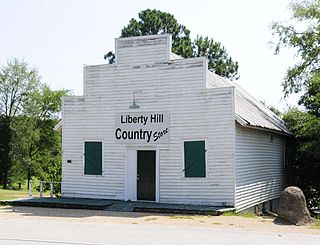
Liberty Hill is an unincorporated community in Kershaw County, South Carolina, United States. The community is located at the junction of South Carolina Highway 97 and South Carolina Highway 522, 19.5 miles (31.4 km) northwest of Camden. Liberty Hill has a post office with ZIP code 29074, which opened on January 19, 1818.
White Stone is an unincorporated community in Spartanburg County, South Carolina, United States. The community is located along South Carolina Highway 295, 7.3 miles (11.7 km) east-southeast of Spartanburg. White Stone has a post office with ZIP code 29386, which opened on February 2, 1827.
Eldred is a rural hamlet located in the central part of the town of Highland, Sullivan County, New York, United States. The community is located along New York State Route 55, approximately 13.5 miles (21.7 km) southwest of Monticello. Eldred has a post office, which opened on October 5, 1831, with the current ZIP code as 12732. Other points of interest in the hamlet include the Highland Town Hall, Sunshine Hall Free Library, a firehouse, several churches and parks, and a Dollar General store. Public education in Eldred is serviced through the Eldred Central School District.
Greenfield Park is a hamlet in Ulster County, New York, United States. The community is located along New York State Route 52 4.7 miles (7.6 km) west of Ellenville. Greenfield Park has a post office with ZIP code 12435, which opened on December 23, 1852.
Verona Beach is a hamlet in Oneida County, New York, United States. The community is located along the eastern shore of Oneida Lake and New York State Route 13; the Erie Canal separates the community from neighboring Sylvan Beach. Verona Beach has a post office with ZIP code 13162. Verona Beach State Park is located in the community.
South New Berlin is a hamlet in Chenango County, New York, United States. The community is located along the Unadilla River at the intersection of New York State Route 8 and New York State Route 23, 7.1 miles (11.4 km) east of Norwich. South New Berlin has a post office with ZIP code 13843, which opened on July 20, 1822.
South Plymouth is a hamlet in Chenango County, New York, United States. The community is located along New York State Route 23 4 miles (6.4 km) north-northwest of Norwich. South Plymouth has a post office with ZIP code 13844, which opened on April 20, 1848.

West Oneonta is a hamlet in Otsego County, New York, United States. The community is located along New York State Route 23, 3 miles (4.8 km) west-northwest of Oneonta. West Oneonta has a post office with ZIP code 13861.
Farmersville Station is a hamlet in Cattaraugus County, New York, United States. The community is located along New York State Route 98 8 miles (13 km) northeast of Franklinville. Farmersville Station has a post office with ZIP code 14060, which opened on October 23, 1878.
Stella Niagara is a hamlet in Niagara County, New York, United States. The community is located along the Niagara River and New York State Route 18F 7.3 miles (11.7 km) north of Niagara Falls. Stella Niagara had a post office until July 19, 1997; it still has its own ZIP code, 14144.


