Following the proclamation of the Republic, Turkish museums developed considerably, mainly due to the importance Atatürk had attached to the research and exhibition of artifacts of Anatolia. When the Republic of Turkey was proclaimed, there were only the İstanbul Archaeology Museum called the "Asar-ı Atika Müzesi", the Istanbul Military Museum housed in the St. Irene Church, the Islamic Museum in the Suleymaniye Complex in Istanbul and the smaller museums of the Ottoman Empire Museum in a few large cities of Anatolia.
The Turkish football system is divided into the following leagues.
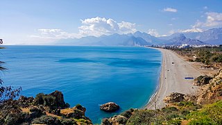
The Mediterranean Region is a geographical region of Turkey. The largest city in the region is Antalya. Other big cities are Adana, Mersin, Isparta, Antakya and Kahramanmaraş.
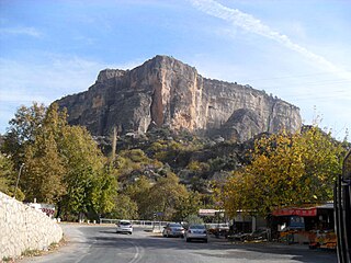
The Sertavul Pass is a mountain pass situated on the central Taurus Mountains at the border of Mersin Province with Karaman Province on the road from Konya over Karaman to the Mediterranean coast at Anamur or Silifke.
There are 81 provinces in Turkey. Among the 81 provinces, 30 provinces are designated metropolitan municipalities. Metropolitan municipalities are subdivided into districts, where each district includes a corresponding district municipality, which is a second tier municipality.

The State Railways of the Republic of Turkey, abbreviated as TCDD, is a government-owned national railway company responsible with the ownership and maintenance of railway infrastructure in Turkey, as well as the planning and construction of new lines. TCDD was formed on 4 June 1929 as part of the nationalisation of railways in Turkey.

The General Directorate Of Highways (KGM) is a state agency in charge of the construction and maintenance of all public roadways outside of cities and towns in Turkey. It was established on 1 March 1950, following the acceptance of the International Highways Act in 1949. The agency is a sub unit of the Ministry of Transport and Infrastructure.
State road D.715 is a north-to-south state road in Turkey. The northern end of the 415-kilometre (258 mi) road merges with State road D.750 at a location popularly known as Kulu makası north of Lake Tuz. The southern end of the road merges with State road D.400 in Silifke. D-715 runs through the provinces of Konya, Karaman and Mersin.

Radio Çukurova is a regional radio network of the Turkish Radio and Television Corporation (TRT).

The Cyprus Memorial Forest, a.k.a. Cyprus Memorial Cemetery, is a memorial forest including a symbolic military cemetery and an open-air museum dedicated to the Turkish servicemen killed in action during the 1974 Turkish military invasion of Cyprus. Established in 1976, it is located at Silifke district of Mersin Province in southern Turkey.
Mersin İdmanyurdu Sports Club; located in Mersin, east Mediterranean coast of Turkey in 1961–62. Mersin İdmanyurdu (MİY) football team.

The Governor of Mersin is the bureaucratic state official responsible for both national government and state affairs in the Province of Mersin. Similar to the governors of the 80 other Provinces of Turkey, the Governor of Mersin is appointed by the government of Turkey and is responsible for the implementation of government legislation within Mersin. The governor is also the most senior commander of both the Mersin provincial police force and the Mersin Gendarmerie.

Governor of Konya is the civil service official responsible for both national government and state affairs in the Province of Konya. Similar to the Governors of the 80 other Provinces of Turkey, the Governor of Konya is appointed by the Government of Turkey and is responsible for the implementation of government legislation within Konya. The Governor is also the most senior commander of both the Konya provincial police force and the Konya Gendarmerie.

Otoyol 21A, abbreviated as O-21A, is a 32 km (20 mi) long auxiliary otoyol connecting the D.330 and D.750 to the O-21. The motorway was opened in 1992 as a connecting route to Konya and passes through mostly uninhabited rural land. The O-21A is a part of the E90.
Sıt is the Turkish word for archaeological site. The governmental committees named Cultural Assets Conservation Committees determine the archaeological sites. As of 2015 there were 14861 sit areas in Turkey. With a history including Hittites, Hellenistic Age, Roman and Byzantine Empires, Seljuks and the Ottoman Empire, Turkey is full of archaeological sites Below is the number of Sıt areas in Turkey classified according to the Turkish provinces (il).
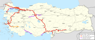
The Otoyol is the national network of controlled-access highways in Turkey. The term Otoyol translates to motorway while the literal meaning is auto-route. The Otoyol was first opened in 1973.

The Konya–Yenice railway is a 344.7 km (214.2 mi) long, partially electrified railway in southern Turkey. The railway is a major route connecting Turkey's Mediterranean coast to the Anatolian interior as well as the only railway line through the Taurus Mountains. The line begins in Konya and runs southeast through Karaman until turning south at Ulukışla and joining the Adana–Mersin railway at Yenice. The section between Konya and Karaman is classified as a High-standard railway, while the rest of the route is classified as a Conventional railway.
The Mersin–Adana–Gaziantep high-speed railway, known officially as the Mersin–Adana–Gaziantep higher-speed railway and abbreviated as MAG, is a 303 km (188 mi) long high-speed/higher-speed railway corridor currently under construction in southern Turkey. Beginning at Mersin, on the Mediterranean Sea, the railway corridor stretches inland to Gaziantep, via Yenice, Adana and Osmaniye. The scope of the project includes the upgrading of three existing railway lines, the construction of a new railway tunnel bypass, and the construction of a new, direct rail-link to Gaziantep.
This page is based on this
Wikipedia article Text is available under the
CC BY-SA 4.0 license; additional terms may apply.
Images, videos and audio are available under their respective licenses.