Stienta

Last updated
Stienta
Comune
Comune di Stienta
Italy provincial location map 2015.svg
Red pog.svg
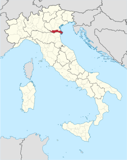
Stienta
Location of Stienta in Italy
Coordinates: 44°56′N11°33′E / 44.933°N 11.550°E / 44.933; 11.550 Coordinates: 44°56′N11°33′E / 44.933°N 11.550°E / 44.933; 11.550
Country Italy
Region Veneto
Province Province of Rovigo (RO)
Frazioni Argine Sabato, Argine Valle Est, Argine Valle Ovest, Beccari, Bentivoglio, Boaria Gilliola, Boaria Guerra, Boaria Roveta, Boaria Val dell'Oca e Casetta, Boaria Val di Mezzo, Boaria Varotta, Brigo, Chiavicone, Fazzenda, Folega, Guratti, Ponte Favarzano, Prati Nuovi, Sabbioni, Zampine
Area
  Total 24.1 km2 (9.3 sq mi)
Population (Dec. 2004)
  Total 3,118
  Density 130/km2 (340/sq mi)
Demonym(s) Stientesi
Time zone CET (UTC+1)
  Summer (DST) CEST (UTC+2)
Postal code45039
Dialing code 0425
Website Official website

Stienta is a comune (municipality) in the Province of Rovigo in the Italian region Veneto, located about 80 kilometres (50 mi) southwest of Venice and about 25 kilometres (16 mi) southwest of Rovigo. As of 31 December 2004, it had a population of 3,118 and an area of 24.1 square kilometres (9.3 sq mi). [1]

<i>Comune</i> third-level administrative divisions of the Italian Republic

The comune is a basic administrative division in Italy, roughly equivalent to a township or municipality.

Province of Rovigo Province of Italy

The Province of Rovigo is a province in the Veneto region of Italy. Its capital is the city of Rovigo. It borders on the north with the provinces of Verona, Padua and Venice, on the south with the province of Ferrara, on the west with the province of Mantua, and on the east with the Adriatic Sea.

Italy republic in Southern Europe

Italy, officially the Italian Republic, is a country in Europe. Located in the middle of the Mediterranean Sea, Italy shares open land borders with France, Switzerland, Austria, Slovenia and the enclaved microstates San Marino and Vatican City. Italy covers an area of 301,340 km2 (116,350 sq mi) and has a largely temperate seasonal and Mediterranean climate. With around 61 million inhabitants, it is the fourth-most populous EU member state and the most populous country in Southern Europe.

Contents

The municipality of Stienta contains the frazioni (subdivisions, mainly villages and hamlets) Argine Sabato, Argine Valle Est, Argine Valle Ovest, Beccari, Bentivoglio, Boaria Gilliola, Boaria Guerra, Boaria Roveta, Boaria Val dell'Oca e Casetta, Boaria Val di Mezzo, Boaria Varotta, Brigo, Chiavicone, Fazzenda, Folega, Guratti, Ponte Favarzano, Prati Nuovi, Sabbioni, and Zampine.

"Frazione" is the Italian name given in administrative law to a type of territorial subdivision of a comune; for other administrative divisions, see municipio, circoscrizione, quartiere. It is cognate to the English word fraction, but in practice is roughly equivalent to "parishes" or "wards" in other countries.

Stienta borders the following municipalities: Bagnolo di Po, Castelguglielmo, Ferrara, Fiesso Umbertiano, Gaiba, Occhiobello.

Bagnolo di Po Comune in Veneto, Italy

Bagnolo di Po is a comune in the province of Rovigo, in Veneto, northern Italy. It is bounded by other communes of Castelguglielmo, Trecenta, Canda, and Ficarolo.

Castelguglielmo Comune in Veneto, Italy

Castelguglielmo is a comune (municipality) in the Province of Rovigo in the Italian region Veneto, located about 80 kilometres (50 mi) southwest of Venice and about 20 kilometres (12 mi) southwest of Rovigo. As of 31 December 2004, it had a population of 1,730 and an area of 22.1 square kilometres (8.5 sq mi).

Ferrara Comune in Emilia-Romagna, Italy

Ferrara is a city and comune in Emilia-Romagna, northern Italy, capital of the Province of Ferrara. As of 2016 it had 132,009 inhabitants. It is situated 44 kilometres northeast of Bologna, on the Po di Volano, a branch channel of the main stream of the Po River, located 5 km north. The town has broad streets and numerous palaces dating from the Renaissance, when it hosted the court of the House of Este. For its beauty and cultural importance, it has been designated by UNESCO as a World Heritage Site.

Demographic evolution

Stienta

Related Research Articles

Bozzolo Comune in Lombardy, Italy

Bozzolo is a comune (municipality) in the Province of Mantua in the Italian region Lombardy, located about 110 kilometres (68 mi) southeast of Milan and about 25 kilometres (16 mi) southwest of Mantua.

La Valle Agordina Comune in Veneto, Italy

La Valle Agordina is a comune (municipality) in the Province of Belluno in the Italian region Veneto, located about 90 kilometres (56 mi) north of Venice and about 20 kilometres (12 mi) northwest of Belluno. As of 31 December 2004, it had a population of 1,217 and an area of 48.7 square kilometres (18.8 sq mi).

Arquà Polesine Comune in Veneto, Italy

Arquà Polesine is a comune (municipality) in the Province of Rovigo in the Italian region Veneto, located about 70 kilometres (43 mi) southwest of Venice and about 7 kilometres (4 mi) southwest of Rovigo.

Bergantino Comune in Veneto, Italy

Bergantino is a comune (municipality) in the Province of Rovigo in the Italian region Veneto, located about 90 kilometres (56 mi) southwest of Venice and about 40 kilometres (25 mi) west of Rovigo.

Canda Comune in Veneto, Italy

Canda is a comune (municipality) in the Province of Rovigo in the Italian region Veneto, located about 80 km southwest of Venice and about 20 kilometres (12 mi) west of Rovigo. As of 31 December 2004, it had a population of 958 and an area of 14.4 square kilometres (5.6 sq mi).

Costa di Rovigo Comune in Veneto, Italy

Costa di Rovigo is a comune (municipality) in the Province of Rovigo in the Italian region Veneto, located about 60 kilometres (37 mi) southwest of Venice and about 7 kilometres (4 mi) southwest of Rovigo.

Crespino Comune in Veneto, Italy

Crespino is a comune (municipality) in the Province of Rovigo in the Italian region Veneto, located about 60 kilometres (37 mi) southwest of Venice and about 12 kilometres (7 mi) southeast of Rovigo. As of 31 December 2004, it had a population of 2,111 and an area of 31.9 square kilometres (12.3 sq mi).

Ficarolo Comune in Veneto, Italy

Ficarolo is a comune (municipality) in the Province of Rovigo in the Italian region Veneto, located about 90 kilometres (56 mi) southwest of Venice and about 30 kilometres (19 mi) southwest of Rovigo.

Fiesso Umbertiano Comune in Veneto, Italy

Fiesso Umbertiano is a comune (municipality) in the Province of Rovigo in the Italian region Veneto, located about 80 kilometres (50 mi) southwest of Venice and about 20 kilometres (12 mi) southwest of Rovigo. As of 31 December 2004, it had a population of 4,207 and an area of 27.3 square kilometres (10.5 sq mi).

Frassinelle Polesine Comune in Veneto, Italy

Frassinelle Polesine is a comune (municipality) in the Province of Rovigo in the Italian region Veneto, located about 70 kilometres (43 mi) southwest of Venice and about 10 kilometres (6 mi) southwest of Rovigo. As of 31 December 2004, it had a population of 1,559 and an area of 21.9 square kilometres (8.5 sq mi).

Pettorazza Grimani Comune in Veneto, Italy

Pettorazza Grimani is a comune (municipality) in the Province of Rovigo in the Italian region Veneto, located about 40 kilometres (25 mi) southwest of Venice and about 20 kilometres (12 mi) northeast of Rovigo.

Salara Comune in Veneto, Italy

Salara is a comune (municipality) in the Province of Rovigo in the Italian region Veneto, located about 90 kilometres (56 mi) southwest of Venice and about 30 kilometres (19 mi) southwest of Rovigo.

San Bellino Comune in Veneto, Italy

San Bellino is a comune (municipality) in the Province of Rovigo in the Italian region Veneto, located about 73 kilometres (45 mi) southwest of Venice and about 15 kilometres (9 mi) west of Rovigo.

San Martino di Venezze Comune in Veneto, Italy

San Martino di Venezze is a comune (municipality) in the Province of Rovigo in the Italian region Veneto, located about 50 kilometres (31 mi) southwest of Venice and about 10 kilometres (6 mi) northeast of Rovigo.

Trecenta Comune in Veneto, Italy

Trecenta is a comune (municipality) in the Province of Rovigo in the Italian region Veneto, located about 80 kilometres (50 mi) southwest of Venice and about 25 kilometres (16 mi) west of Rovigo.

Villadose Comune in Veneto, Italy

Villadose is a comune (municipality) in the Province of Rovigo in the Italian region Veneto, located about 50 kilometres (31 mi) southwest of Venice and about 8 kilometres (5 mi) east of Rovigo. As of 31 December 2004, it had a population of 5,303 and an area of 32.5 square kilometres (12.5 sq mi).

Villamarzana Comune in Veneto, Italy

Villamarzana is a comune (municipality) in the Province of Rovigo in the Italian region Veneto, located about 70 kilometres (43 mi) southwest of Venice and about 10 kilometres (6 mi) southwest of Rovigo. As of 31 December 2004, it had a population of 1,176 and an area of 14.1 square kilometres (5.4 sq mi).

Villanova del Ghebbo Comune in Veneto, Italy

Villanova del Ghebbo is a comune (municipality) in the Province of Rovigo in the Italian region Veneto, located about 70 kilometres (43 mi) southwest of Venice and about 10 kilometres (6 mi) west of Rovigo. As of 31 December 2004, it had a population of 2,209 and an area of 11.8 square kilometres (4.6 sq mi).

Villanova Marchesana Comune in Veneto, Italy

Villanova Marchesana is a comune (municipality) in the Province of Rovigo in the Italian region Veneto, located about 60 kilometres (37 mi) southwest of Venice and about 15 kilometres (9 mi) southeast of Rovigo. As of 31 December 2004, it had a population of 1,109 and an area of 18.2 square kilometres (7.0 sq mi).

References

  1. All demographics and other statistics: Italian statistical institute Istat.