Duncan is a census-designated place (CDP) in Hancock County, Iowa, United States. The population was 131 at the 2010 census.
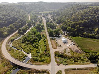
Dorchester is an unincorporated community in northwestern Allamakee County, Iowa, United States. It lies along local roads just off Iowa Highway 76, north of the city of Waukon, the county seat of Allamakee County. Its elevation is 738 feet (225 m). The town was originally settled by Harvey Bell and Edmund Bell, and was named after Dorchester, England. Although Dorchester is unincorporated, it has a post office, with the ZIP code of 52140, which opened on 21 May 1857. Dorchester is located in Waterloo Township.
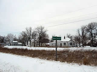
New Boston is an unincorporated community in central Lee County, Iowa, United States. It lies in the southeast corner of Iowa, along U.S. Highway 218 and southwest of the city of Fort Madison, the county seat of Lee County. New Boston is located nearby to the unincorporated communities of Argyle, Iowa and Charleston, Iowa. The community is part of the Fort Madison–Keokuk, IA-MO Micropolitan Statistical Area. There are no commercial establishments in New Boston, although this is the home of Liberty Baptist Church.
Lycurgus is a rural unincorporated community in Allamakee County, Iowa, United States.
Volney is an unincorporated community in Allamakee County, Iowa, United States.
Mederville is an unincorporated community in Clayton County, Iowa, United States.
Osborne is an unincorporated community in Clayton County, Iowa, United States.
Loveland is a census-designated place in Pottawattamie County, Iowa, United States.
Miller is an unincorporated community and census-designated place in Hancock County, Iowa, United States. As of the 2010 census, the population was 60.
Hutchins is an unincorporated community and census-designated place in Hancock County, Iowa, United States. As of the 2010 census the population was 28.
Waukon Junction is an unincorporated community in Allamakee County, Iowa, United States.
Maud is an unincorporated community in Allamakee County, Iowa, United States.
Dean is an unincorporated community in Appanoose County, Iowa, United States.
Olaf is an unincorporated community in Wright County, Iowa, United States.
Watson is an unincorporated community in Clayton County, Iowa, United States. The county seat of Elkader lies approximately 15 miles to the southwest.
Turkey River is an unincorporated community in Clayton County, Iowa, United States. The community of Turkey River borders the Mississippi River, and the Turkey River. Turkey River also is situated on Iowa's border with Wisconsin.

Plainview is an unincorporated community in Cleona and Hickory Grove Townships, Scott County, Iowa, United States. Plainview is located along Iowa Highway 130 5.7 miles (9.2 km) north of Walcott.
Oneida is an unincorporated community in Oneida Township, Delaware County, Iowa, United States. The community is on county highway D13, 3 miles (4.8 km) south of Greeley.
Douglas is an unincorporated community in Fayette County, Iowa, United States. It is located near the junction of County Road B44 and Maple Road, three miles southwest of Eldorado.
Alice is an unincorporated community in Linn County, in the U.S. state of Iowa.

