
Newell Highway is a national highway in New South Wales (NSW), Australia. It provides the major road link between southeastern Queensland and Victoria via central NSW and as such carries large amounts of freight. At 1,058 kilometres (657 mi) in length, the Newell is the longest highway in NSW, and passes through fifteen local government areas.
Terowie is a small town in the Mid North region of South Australia located 220 kilometres (137 mi) north of the state capital of Adelaide. It is located in the Regional Council of Goyder. Terowie retains a number of authentic and well preserved 1880s buildings, and has been declared a "historic town". It also remains a town of interest to those interested in rail history. Although now a very small town with few facilities, Terowie remains a popular destination for photographers, historians, and rail buffs. At the 2016 census, Terowie had a population of 131.

Truro is a town in South Australia, 80 km northeast of Adelaide. It is situated in an agricultural and pastoral district on the Sturt Highway, east of the Barossa Valley, where the highway crosses somewhat lofty and rugged parts of the Mount Lofty Ranges. At the 2021 census, Truro had a population of 523.

Northern Areas Council is a local government area in the Yorke and Mid North region of South Australia. The council seat and main council offices are at Jamestown, while the council also maintains district offices at Gladstone and Spalding.
Laura is a rural town in the Mid North region of South Australia, 12 km north of Gladstone on the Horrocks Highway and 40 km east of Port Pirie. The first European to explore the district was Thomas Burr in September 1842. His promising reports soon led to occupation of the district by pastoralists, one of whom was Herbert Bristow Hughes. When the present town was surveyed he named it for his wife, Laura née White.

Boyanup is a town on the South Western Highway in the South West agricultural region, 195 km south of Perth and 18 km south-east of Bunbury, Western Australia. The town is located on the Preston River.

The Mount Remarkable District Council is a local government area located between the top of the Spencer Gulf and the base of the Southern Flinders Ranges in South Australia. The district encompasses a wide variety of towns, including coastal ports and agricultural centres. The economy of the district council is largely based on agriculture.
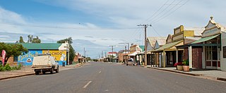
Booleroo Centre is a town in the southern Flinders Ranges region of South Australia. The town is located in the Mount Remarkable District Council local government area, 282 kilometres (175 mi) north of the state capital, Adelaide. At the 2006 census, Booleroo Centre had a population of 516.

Sedan is a rural town in South Australia. It is located about 100 kilometres east of Adelaide and about 20 kilometres west of the Murray River. It is located on the dry eastern side of the Mount Lofty Ranges.
Wirrabara is a town and a locality in South Australia, about 235 kilometres (146 mi) north of Adelaide. It is located in the Southern Flinders Ranges in the Mid North of South Australia, along the Rocky River. The Horrocks Highway passes through the town. At the 2016 census, the locality had a population of 403 of which 230 lived in its town centre.
Canowie or Canowie Station was a former pastoral lease located about 18 kilometres (11 mi) north west of Hallett and 23 kilometres (14 mi) south west of Terowie in the state of South Australia.
Rocky River was an electoral district of the House of Assembly in the Australian state of South Australia from March 1938 to December 1985.
The District Council of Port Germein was a local government area in South Australia, centred on the town of Port Germein. It was gazetted on 5 January 1888 under the provisions of the District Councils Act 1887 and encompassed the hundreds of Baroota, Wongyarra, Booleroo, Telowie, Darling and Appila. It replaced an abortive earlier municipality, the Corporate Town of Port Germein, which had been established on 15 September 1887 when residents, concerned about increased taxation and their interests being lost in a broader shire under the forthcoming reforms, decided to incorporate the town. The local residents reportedly regretted the decision, and when the Act passed late in the year creating the new District Council, state parliament agreed to amalgamate the Corporate Town into the new municipality.
The Rocky River is a river located in the Mid North region of the Australian state of South Australia.
Honiton is a locality in the Australian state of South Australia located on the south coast of Yorke Peninsula immediately adjoining Investigator Strait about 89 kilometres west of the state capital of Adelaide and about 5 kilometres west of the Edithburgh town centre.
Bundaleer North is a rural locality in the Mid North region of South Australia, situated in the Northern Areas Council. Its modern boundaries were established in April 2001 for the long established local name. Bundaleer North is divided by the RM Williams Way between the Bundaleer Forest Reserve to the west and agricultural land to the east.
Mannanarie is a rural locality in the Mid North region of South Australia, situated in the Northern Areas Council. It was established in April 2001, when boundaries were formalised for the "long established local name". It comprises most of the cadastral Hundred of Mannanarie, apart from a northern section which lies in Tarcowie and Yatina. The name stems from an Aboriginal word, "manangari", meaning "good string or cord", stemming from a local native plant useful for string making.

The County of Frome is one of the 49 cadastral counties of South Australia in straddling the Mid North and Flinders Ranges regions. It was proclaimed in 1851 by Governor Henry Young and was named for the former Surveyor-General of South Australia, Edward Charles Frome. The iconic Mount Remarkable in the Hundred of Gregory is at the centre of the county.
Wirrabara Range Conservation Park was a protected area located in the Australian state of South Australia in the locality of Wirrabara about 215 kilometres (134 mi) north of the state capital of Adelaide and about 11 kilometres (6.8 mi) west of the town of Wirrabara. On 26 November 2021 it became part of the Wapma Thura–Southern Flinders Ranges National Park, along with several other conservation parks.

Wapma Thura–Southern Flinders Ranges National Park is a protected area in the southern Flinders Ranges in South Australia, proclaimed on 25 November 2021. The area comprises several former conservation parks.

