Subprefecture of Itaim Paulista

Last updated
Subprefecture of Itaim Paulista
Subprefecture
SP-Itaim Paulista.GIF
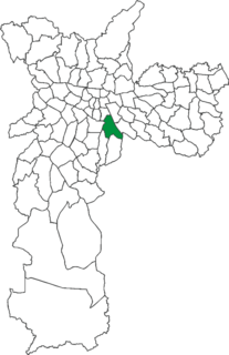
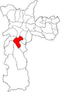
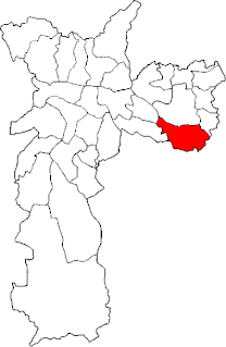
Location of the Subprefecture of Itaim Paulista in São Paulo
SaoPaulo Municip SaoPaulo.svg
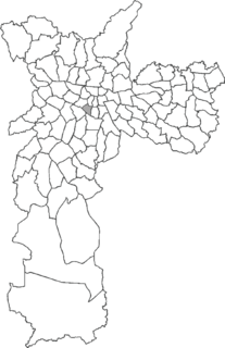
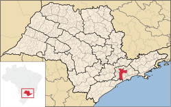
Location of municipality of São Paulo within the State of São Paulo
Country Flag of Brazil.svg  Brazil
Region Southeast
State Bandeira do Estado de Sao Paulo.svg São Paulo
Municipality Sao Paulo City flag.svg São Paulo
Administrative Zone East 2
Districts Itaim Paulista, Vila Curuçá
Government
  Type Subprefecture
   Subprefect Irene Mitsue Inada
Area
  Total 21.72 km2 (8.39 sq mi)
Population (2008)
  Total 399,140
Website Subprefeitura Itaim Paulista (Portuguese)

The Subprefecture of Itaim Paulista is one of 32 subprefectures of the city of São Paulo, Brazil. It comprises two districts: Itaim Paulista and Vila Curuçá. [1]

A subprefecture is an administrative division of a country that is below prefecture or province.

São Paulo Municipality in Brazil

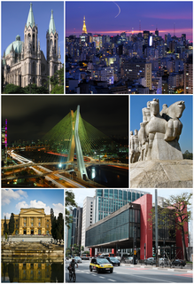
São Paulo is a municipality in the Southeast Region of Brazil. The metropolis is an alpha global city and the most populous city in Brazil, the Western Hemisphere and the Southern Hemisphere, besides being the largest Portuguese-speaking city in the world. The municipality is also the Earth's 11th largest city proper by population. The city is the capital of the surrounding state of São Paulo, the most populous and wealthiest state in Brazil. It exerts strong international influences in commerce, finance, arts and entertainment. The name of the city honors the Apostle, Saint Paul of Tarsus. The city's metropolitan area, the Greater São Paulo, ranks as the most populous in Brazil and the 12th most populous on Earth. The process of conurbation between the metropolitan areas located around the Greater São Paulo created the São Paulo Macrometropolis, a megalopolis with more than 30 million inhabitants, one of the most populous urban agglomerations in the world.

Brazil Federal republic in South America

Brazil, officially the Federative Republic of Brazil, is the largest country in both South America and Latin America. At 8.5 million square kilometers and with over 208 million people, Brazil is the world's fifth-largest country by area and the fifth most populous. Brazil borders every South American country except Chile and Ecuador. Its capital is Brasília, and its most populated city is São Paulo. The federation is composed of the union of the 26 states, the Federal District, and the 5,570 municipalities. It is the largest country to have Portuguese as an official language and the only one in the Americas; it is also one of the most multicultural and ethnically diverse nations, due to over a century of mass immigration from around the world.

It's the easternmost subprefecture. Its population consists largely of migrants from the north-east of Brazil, in particular from the states of Bahia and Pernambuco. Earlier immigrants came from Italy, Japan and Hungary. [2]

Bahia State of Brazil

Bahia is one of the 26 states of Brazil and is located in the northeastern part of the country on the Atlantic coast. It is the 4th-largest Brazilian state by population and the 5th-largest by area. Bahia's capital is the city of Salvador, located on a spit of land separating the Bay of All Saints from the Atlantic. Once a monarchial stronghold dominated by agricultural, slaving, and ranching interests, Bahia is now a major manufacturing center whose last three elections have been dominated by the Workers' Party.

Pernambuco State of Brazil

Pernambuco is a state of Brazil, located in the Northeast region of the country. The state of Pernambuco also includes the archipelago Fernando de Noronha. With an estimated population of 9.2 million people in 2013, it is the seventh most populous state of Brazil, and is the sixth most densely populated and the 19th most extensive among the states and territories of the country. Its capital and largest city, Recife, is one of the most important economic and urban hubs in the country. As of 2013 estimates, Recife's metropolitan area is the fifth most populous in the country, and the largest urban agglomeration in Northeast Brazil.

Related Research Articles

Morumbi, São Paulo Place in São Paulo, Brazil

Morumbi is a district of the city of São Paulo belonging to the subprefecture of Butantã, in the southwestern part of the city. A common folk etymology attributes its name to the mixed Portuguese and Tupi phrase morro obi, which would mean "green hill", but this is disputed.

Ipiranga (district of São Paulo) Place in São Paulo, Brazil

Ipiranga is an historical district located in the subprefecture of the same name of São Paulo, Brazil. The name Ipiranga comes from the river of the same name located in the region, which means "red river" in a Tupí–Guaraní language. The Independence Park, where supposedly the Emperor Pedro I of Brazil proclaimed the independence of Brazil, the Paulista Museum, which exhibits classic architecture and a collection of Brazilian colonial artifacts, and the Museum of Zoology of the University of São Paulo, are also located in Ipiranga.

Bela Vista Place in São Paulo, Brazil

Bela Vista is one of the most traditional Italian neighborhoods in the city of São Paulo, Brazil. It belongs to the borough of Sé, and it has been a mixed neighborhood since its beginning, where free African-Brazilians and/or a mixture of Native-Brazilians, Blacks and Portuguese descendants lived. Later, more European immigrants arrived, such as Spaniards, Germans, English, French, Belgians, and Italians. The Italian community became more numerous than all the others during the first decades of the twentieth century.

Itaim Paulista Place in São Paulo, Brazil

Itaim Paulista is a district in the subprefecture of the same name in the city of São Paulo, Brazil. The name Itaim comes from Tupi and means Little Stone.

Itaim Bibi Place in São Paulo, Brazil

Itaim Bibi is a district in the subprefecture of Pinheiros in the city of São Paulo, Brazil. It includes in its area a neighbourhood of the same name.

Vila Curuçá Place in São Paulo, Brazil

Vila Curuçá is a municipal District located in the eastern section, Zona Leste, of the city and prefecture of São Paulo, Brazil. It is one of the two districts making up the subprefecture of Itaim Paulista.

Subprefecture of Butantã Subprefecture in Southeast, Brazil

The Subprefecture of Butantã is one of 32 subprefectures of the city of São Paulo, Brazil. It comprises five districts: Butantã, Morumbi, Vila Sônia, Raposo Tavares, and Rio Pequeno. It hosts the main campus of University of São Paulo and the headquarters of São Paulo Futebol Clube, one of the largest teams of the city. The headquarters of Rede Bandeirantes, one of the largest media groups of Brazil, are also in this subprefecture.

Subprefecture of Campo Limpo Subprefecture in Southeast, Brazil

The Subprefecture of Campo Limpo is one of 32 subprefectures of the city of São Paulo, Brazil. It comprises three districts: Campo Limpo, Capão Redondo, and Vila Andrade. The slum of Paraisópolis, the second largest of the city and surrounded by middle-to-upper class apartment buildings, is located here.

Subprefecture of Casa Verde Subprefecture in Southeast, Brazil

The Subprefecture of Casa Verde is one of 32 subprefectures of the city of São Paulo, Brazil. It comprises three districts: Casa Verde, Cachoeirinha, and Limão.

Subprefecture of Ipiranga Subprefecture in Southeast, Brazil

The Subprefecture of Ipiranga is one of 32 subprefectures of the city of São Paulo, Brazil. It comprises three districts: Ipiranga, Cursino, and Sacomã. This subprefecture hosts the Ipiranga Museum and the Parque da Independência, where the independence of Brazil was proclaimed.

Subprefecture of Jaçanã-Tremembé Subprefecture in Southeast, Brazil

The Subprefecture of Jaçanã-Tremembé is one of 32 subprefectures of the city of São Paulo, Brazil. It comprises two districts: Jaçanã and Tremembé. It's the northernmost subprefecture and largely covered by parts of the Atlantic Forest.

Subprefecture of Parelheiros Subprefecture in Southeast, Brazil

The Subprefecture of Parelheiros is one of 32 subprefectures of the city of São Paulo, Brazil. It comprises two districts: Parelheiros and Marsilac.

Subprefecture of Pinheiros Subprefecture in Southeast, Brazil

The Subprefecture of Pinheiros is one of 32 subprefectures of the city of São Paulo, Brazil. It comprises four districts: Pinheiros, Alto de Pinheiros, Itaim Bibi, and Jardim Paulista.

Subprefecture of Santo Amaro Subprefecture in Southeast, Brazil

The Subprefecture of Santo Amaro is one of 32 subprefectures of the city of São Paulo, Brazil. It comprises three districts: Santo Amaro, Campo Belo, and Campo Grande.

Subprefecture of São Mateus Subprefecture in Southeast, Brazil

The Subprefecture of São Mateus is one of 32 subprefectures of the city of São Paulo, Brazil. It comprises three districts: São Mateus, São Rafael, and Iguatemi.

Subprefecture of São Miguel Paulista Subprefecture in Southeast, Brazil

The Subprefecture of São Miguel Paulista is one of 32 subprefectures of the city of São Paulo, Brazil. It comprises three districts: São Miguel Paulista, Jardim Helena, and Vila Jacuí.

Subprefecture of Sé Subprefecture in Southeast, Brazil

The Subprefecture of Sé is one of 32 subprefectures of the city of São Paulo, Brazil. It comprises eight districts: Bela Vista, Bom Retiro, Cambuci, Consolação, Liberdade, República, Sé, Santa Cecília. This subprefecture forms the inner city, historical core of the city. The São Paulo Stock Exchange is also located in this area.

Subprefecture of Vila Mariana Subprefecture in Southeast, Brazil

The Subprefecture of Vila Mariana is one of 32 subprefectures of the city of São Paulo, Brazil. It comprises three districts: Vila Mariana, Saúde, and Moema.

Subprefecture of Vila Prudente Subprefecture in Southeast, Brazil

The Subprefecture of Vila Prudente is one of 32 subprefectures of the city of São Paulo, Brazil. It comprises two districts: Vila Prudente and São Lucas.

São Miguel Paulista is a district in the subprefecture of the same name in the city of São Paulo, Brazil.

References

Coordinates: 23°30′17″S46°23′11″W / 23.50472°S 46.38639°W / -23.50472; -46.38639

Geographic coordinate system Coordinate system

A geographic coordinate system is a coordinate system that enables every location on Earth to be specified by a set of numbers, letters or symbols. The coordinates are often chosen such that one of the numbers represents a vertical position and two or three of the numbers represent a horizontal position; alternatively, a geographic position may be expressed in a combined three-dimensional Cartesian vector. A common choice of coordinates is latitude, longitude and elevation. To specify a location on a plane requires a map projection.