Subprefecture of Vila Maria-Vila Guilherme

Last updated
Subprefecture of Vila Maria-Vila Guilherme
Subprefecture
SP-Vila Maria-Vila Guilherme.GIF
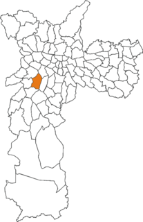
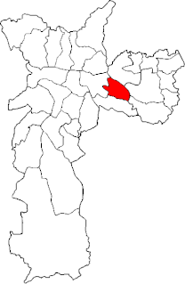
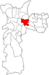
Location of the Subprefecture of Vila Maria-Vila Guilherme in São Paulo
SaoPaulo Municip SaoPaulo.svg
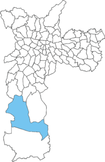
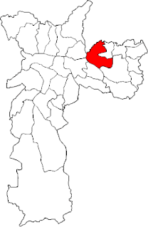
Location of municipality of São Paulo within the State of São Paulo
Country Flag of Brazil.svg  Brazil
Region Southeast
State Bandeira do Estado de Sao Paulo.svg São Paulo
Municipality Sao Paulo City flag.svg São Paulo
Administrative Zone Northeast
Districts Vila Maria, Vila Guilherme, Vila Medeiros
Government
  Type Subprefecture
   Subprefect Antônio de Pádua Perosa
Area
  Total 26.87 km2 (10.37 sq mi)
Population (2008)
  Total 287,866
Website Subprefeitura Vila Maria-Vila Guilherme (Portuguese)

The Subprefecture of Vila Maria-Vila Guilherme is one of 32 subprefectures of the city of São Paulo, Brazil. It comprises three districts: Vila Maria, Vila Guilherme, and Vila Medeiros. [1]

A subprefecture is an administrative division of a country that is below prefecture or province.

São Paulo Municipality in Brazil

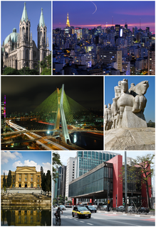
São Paulo is a municipality in the Southeast Region of Brazil. The metropolis is an alpha global city and the most populous city in Brazil, the Western Hemisphere and the Southern Hemisphere, besides being the largest Portuguese-speaking city in the world. The municipality is also the Earth's 11th largest city proper by population. The city is the capital of the surrounding state of São Paulo, the most populous and wealthiest state in Brazil. It exerts strong international influences in commerce, finance, arts and entertainment. The name of the city honors the Apostle, Saint Paul of Tarsus. The city's metropolitan area, the Greater São Paulo, ranks as the most populous in Brazil and the 12th most populous on Earth. The process of conurbation between the metropolitan areas located around the Greater São Paulo created the São Paulo Macrometropolis, a megalopolis with more than 30 million inhabitants, one of the most populous urban agglomerations in the world.

Brazil Federal republic in South America

Brazil, officially the Federative Republic of Brazil, is the largest country in both South America and Latin America. At 8.5 million square kilometers and with over 208 million people, Brazil is the world's fifth-largest country by area and the fifth most populous. Brazil borders every South American country except Chile and Ecuador. Its capital is Brasília, and its most populated city is São Paulo. The federation is composed of the union of the 26 states, the Federal District, and the 5,570 municipalities. It is the largest country to have Portuguese as an official language and the only one in the Americas; it is also one of the most multicultural and ethnically diverse nations, due to over a century of mass immigration from around the world.

This is the subprefecture where are the roads for Rio de Janeiro, Minas Gerais and the São Paulo–Guarulhos International Airport (in the neighbouring municipality of Guarulhos), thus forming an important logistic hub of the city, hosting many transport and storage companies.

Rio de Janeiro Second-most populous municipality in Brazil

Rio de Janeiro, or simply Rio, is anchor to the Rio de Janeiro metropolitan area and the second-most populous municipality in Brazil and the sixth-most populous in the Americas. Rio de Janeiro is the capital of the state of Rio de Janeiro, Brazil's third-most populous state. Part of the city has been designated as a World Heritage Site, named "Rio de Janeiro: Carioca Landscapes between the Mountain and the Sea", by UNESCO on 1 July 2012 as a Cultural Landscape.

Minas Gerais State of Brazil

Minas Gerais is a state in the north of Southeastern Brazil. It ranks as the second most populous, the third by gross domestic product (GDP), and the fourth largest by area in the country. The state's capital and largest city, Belo Horizonte, is a major urban and finance center in Latin America, and the sixth largest municipality in Brazil, after the cities of São Paulo, Rio de Janeiro, Salvador, Brasilia and Fortaleza, but its metropolitan area is the third largest in Brazil with just over 5,500,000 inhabitants, after those of São Paulo and Rio de Janeiro. Nine Brazilian presidents were born in Minas Gerais, the most of any state.

São Paulo–Guarulhos International Airport international airport serving São Paulo, Brazil

São Paulo/Guarulhos–Governador André Franco Montoro International Airport, often referred to as GRU Airport, or simply GRU, is the primary international airport serving São Paulo. It is popularly known locally as either Cumbica Airport, after the district where it is located and the Brazilian Air Force base that still exists at the airport complex, or Guarulhos Airport, after the municipality of Guarulhos, in the São Paulo metropolitan area, where it is located. Since November 28, 2001 the airport has been named after André Franco Montoro (1916–1999), former Governor of São Paulo state. The airport was rebranded as GRU Airport in 2012.

Related Research Articles

Morumbi, São Paulo Place in São Paulo, Brazil

Morumbi is a district of the city of São Paulo belonging to the subprefecture of Butantã, in the southwestern part of the city. A common folk etymology attributes its name to the mixed Portuguese and Tupi phrase morro obi, which would mean "green hill", but this is disputed.

Parelheiros (district of São Paulo) Place in São Paulo, Brazil

Parelheiros is one of 96 districts of the city of São Paulo. Located in the subprefecture of Parelheiros in the extreme south of the city, it is one of the largest and most rural districts. Very little of this area is inhabited, and is covered with reserves of the Atlantic Forest. In Parelheiros there are also two indigenous villages of a Guaraní subgroup with about one thousand residents. The region also received many German immigrants in the beginning of 1800. The inhabitants of the place have the lowest purchasing power of the city. The district is poorly served by public transport and roads; there is little connection to the central districts of the city.

Santana (district of São Paulo) Place in São Paulo, Brazil

Santana is a northern district in the subprefecture of Santana-Tucuruvi of the city of São Paulo, Brazil, and is located between 4–7 km (2.5–4.3 mi) from downtown São Paulo.

Tatuapé Place in São Paulo, Brazil

Tatuapé is a district in the subprefecture of Mooca, in São Paulo, Brazil. It is divided by a railway and the eight lane Radial Leste highway cutting the district into two, northern and southern, parts.

Vila Leopoldina Place in São Paulo, Brazil

Vila Leopoldina is a district in the subprefecture of Lapa in the city of São Paulo, Brazil.

Socorro (district of São Paulo) Place in São Paulo, Brazil

Socorro is a district in the subprefecture of Capela do Socorro, in southern São Paulo, Brazil. Between the Guarapiranga and Billings Reservoirs, lies the Autódromo José Carlos Pace.

Subprefecture of Aricanduva Subprefecture in Southeast, Brazil

The Subprefecture of Aricanduva is one of 32 subprefectures of the city of São Paulo, Brazil. It comprises three districts: Aricanduva, Carrão, and Vila Formosa. The largest graveyard and the largest shopping mall of the city, Centro Comercial Aricanduva, are located in this region.

Subprefecture of Butantã Subprefecture in Southeast, Brazil

The Subprefecture of Butantã is one of 32 subprefectures of the city of São Paulo, Brazil. It comprises five districts: Butantã, Morumbi, Vila Sônia, Raposo Tavares, and Rio Pequeno. It hosts the main campus of University of São Paulo and the headquarters of São Paulo Futebol Clube, one of the largest teams of the city. The headquarters of Rede Bandeirantes, one of the largest media groups of Brazil, are also in this subprefecture.

Subprefecture of Campo Limpo Subprefecture in Southeast, Brazil

The Subprefecture of Campo Limpo is one of 32 subprefectures of the city of São Paulo, Brazil. It comprises three districts: Campo Limpo, Capão Redondo, and Vila Andrade. The slum of Paraisópolis, the second largest of the city and surrounded by middle-to-upper class apartment buildings, is located here.

Subprefecture of Ermelino Matarazzo Subprefecture in Southeast, Brazil

The Subprefecture of Ermelino Matarazzo is one of 32 subprefectures of the city of São Paulo, Brazil. It comprises two districts: Ermelino Matarazzo and Ponte Rasa. It hosts the second largest campus of University of São Paulo in the city.

Subprefecture of Itaim Paulista Subprefecture in Southeast, Brazil

The Subprefecture of Itaim Paulista is one of 32 subprefectures of the city of São Paulo, Brazil. It comprises two districts: Itaim Paulista and Vila Curuçá.

Subprefecture of Jaçanã-Tremembé Subprefecture in Southeast, Brazil

The Subprefecture of Jaçanã-Tremembé is one of 32 subprefectures of the city of São Paulo, Brazil. It comprises two districts: Jaçanã and Tremembé. It's the northernmost subprefecture and largely covered by parts of the Atlantic Forest.

Subprefecture of Lapa Subprefecture in Southeast, Brazil

The Subprefecture of Lapa is one of 32 subprefectures of the city of São Paulo, Brazil. It comprises six districts: Lapa, Barra Funda, Perdizes, Vila Leopoldina, Jaguaré, and Jaguara.

Subprefecture of Mooca Subprefecture in Southeast, Brazil

The Subprefecture of Mooca is one of 32 subprefectures of the city of São Paulo, Brazil. It comprises six districts: Brás, Mooca, Belém, Pari, Água Rasa, and Tatuapé.

Subprefecture of Penha Subprefecture in Southeast, Brazil

The Subprefecture of Penha is one of 32 subprefectures of the city of São Paulo, Brazil. It comprises four districts: Penha, Cangaíba, Vila Matilde, and Artur Alvim.

Subprefecture of Pinheiros Subprefecture in Southeast, Brazil

The Subprefecture of Pinheiros is one of 32 subprefectures of the city of São Paulo, Brazil. It comprises four districts: Pinheiros, Alto de Pinheiros, Itaim Bibi, and Jardim Paulista.

Subprefecture of São Miguel Paulista Subprefecture in Southeast, Brazil

The Subprefecture of São Miguel Paulista is one of 32 subprefectures of the city of São Paulo, Brazil. It comprises three districts: São Miguel Paulista, Jardim Helena, and Vila Jacuí.

Subprefecture of Sé Subprefecture in Southeast, Brazil

The Subprefecture of Sé is one of 32 subprefectures of the city of São Paulo, Brazil. It comprises eight districts: Bela Vista, Bom Retiro, Cambuci, Consolação, Liberdade, República, Sé, Santa Cecília. This subprefecture forms the inner city, historical core of the city. The São Paulo Stock Exchange is also located in this area.

Subprefecture of Vila Mariana Subprefecture in Southeast, Brazil

The Subprefecture of Vila Mariana is one of 32 subprefectures of the city of São Paulo, Brazil. It comprises three districts: Vila Mariana, Saúde, and Moema.

Subprefecture of Vila Prudente Subprefecture in Southeast, Brazil

The Subprefecture of Vila Prudente is one of 32 subprefectures of the city of São Paulo, Brazil. It comprises two districts: Vila Prudente and São Lucas.

References

Coordinates: 23°30′52″S46°34′43″W / 23.51444°S 46.57861°W / -23.51444; -46.57861

Geographic coordinate system Coordinate system

A geographic coordinate system is a coordinate system that enables every location on Earth to be specified by a set of numbers, letters or symbols. The coordinates are often chosen such that one of the numbers represents a vertical position and two or three of the numbers represent a horizontal position; alternatively, a geographic position may be expressed in a combined three-dimensional Cartesian vector. A common choice of coordinates is latitude, longitude and elevation. To specify a location on a plane requires a map projection.