Subprefecture of M'Boi Mirim

Last updated
Subprefecture of M'Boi Mirim
Subprefecture
SP-M'Boi Mirim.GIF
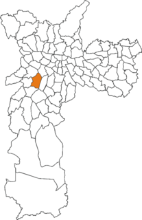
Location of the Subprefecture of M'Boi Mirim in São Paulo
SaoPaulo Municip SaoPaulo.svg
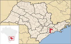
Location of municipality of São Paulo within the State of São Paulo
Coordinates: 23°41′10″S46°46′14″W / 23.68611°S 46.77056°W / -23.68611; -46.77056 Coordinates: 23°41′10″S46°46′14″W / 23.68611°S 46.77056°W / -23.68611; -46.77056
Country Flag of Brazil.svg  Brazil
Region Southeast
State Bandeira do Estado de Sao Paulo.svg São Paulo
Municipality Sao Paulo City flag.svg São Paulo
Administrative Zone South
Districts Jardim Ângela, Jardim São Luís
Government
  Type Subprefecture
   Subprefect Beto Mendes
Area
  Total 62.74 km2 (24.22 sq mi)
Population (2008)
  Total 544,446
Website Subprefeitura M'Boi Mirim (in Portuguese)

The Subprefecture of M'Boi Mirim is one of 32 subprefectures of the city of São Paulo, Brazil. It comprises two districts: Jardim Ângela and Jardim São Luís. [1]

A subprefecture is an administrative division of a country that is below prefecture or province.

São Paulo Municipality in Brazil

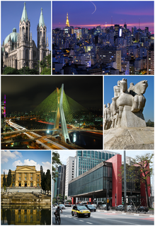
São Paulo is a municipality in the Southeast Region of Brazil. The metropolis is an alpha global city and the most populous city in Brazil, the Western Hemisphere and the Southern Hemisphere, besides being the largest Portuguese-speaking city in the world. The municipality is also the Earth's 11th largest city proper by population. The city is the capital of the surrounding state of São Paulo, the most populous and wealthiest state in Brazil. It exerts strong international influences in commerce, finance, arts and entertainment. The name of the city honors the Apostle, Saint Paul of Tarsus. The city's metropolitan area, the Greater São Paulo, ranks as the most populous in Brazil and the 12th most populous on Earth. The process of conurbation between the metropolitan areas located around the Greater São Paulo created the São Paulo Macrometropolis, a megalopolis with more than 30 million inhabitants, one of the most populous urban agglomerations in the world.

Brazil Federal republic in South America

Brazil, officially the Federative Republic of Brazil, is the largest country in both South America and Latin America. At 8.5 million square kilometers and with over 208 million people, Brazil is the world's fifth-largest country by area and the fifth most populous. Brazil borders every South American country except Chile and Ecuador. Its capital is Brasília, and its most populated city is São Paulo. The federation is composed of the union of the 26 states, the Federal District, and the 5,570 municipalities. It is the largest country to have Portuguese as an official language and the only one in the Americas; it is also one of the most multicultural and ethnically diverse nations, due to over a century of mass immigration from around the world.

The area is serviced by Line 5 of the São Paulo Metro.

Line 5 (São Paulo Metro) line on the Sao Paulo metro

Line 5 (Lilac) is a line of the São Paulo Metro. The southern part of the line is operational. This section was completed in 2002 and was envisioned as a surface railway line of the CPTM called Line G. The project was transferred to the São Paulo Metro and the line was built to rapid transit standard and renamed to Line 5. A northern extension connecting it with the rest of the São Paulo Metro network started construction 2009 with a completion deadline of 2013. The project stalled due to issues with property acquisition and restarted in 2011. The completion deadline of the extension has been delayed several times with the current deadline being March 2019.

Related Research Articles

Morumbi, São Paulo Place in São Paulo, Brazil

Morumbi is a district of the city of São Paulo belonging to the subprefecture of Butantã, in the southwestern part of the city. A common folk etymology attributes its name to the mixed Portuguese and Tupi phrase morro obi, which would mean "green hill", but this is disputed.

Pinheiros Place in São Paulo, Brazil

Pinheiros is a district in the subprefecture of the same name in the city of São Paulo, Brazil. Prior to development, the land which this borough occupies was dominated by the dense forest which contained a Brazilian subtropical species of pine, Araucaria angustifolia, which is also the symbol of the Paraná state.

Parelheiros (district of São Paulo) Place in São Paulo, Brazil

Parelheiros is one of 96 districts of the city of São Paulo. Located in the subprefecture of Parelheiros in the extreme south of the city, it is one of the largest and most rural districts. Very little of this area is inhabited, and is covered with reserves of the Atlantic Forest. In Parelheiros there are also two indigenous villages of a Guaraní subgroup with about one thousand residents. The region also received many German immigrants in the beginning of 1800. The inhabitants of the place have the lowest purchasing power of the city. The district is poorly served by public transport and roads; there is little connection to the central districts of the city.

Santana (district of São Paulo) Place in São Paulo, Brazil

Santana is a northern district in the subprefecture of Santana-Tucuruvi of the city of São Paulo, Brazil, and is located between 4–7 km (2.5–4.3 mi) from downtown São Paulo.

Itaim Paulista Place in São Paulo, Brazil

Itaim Paulista is a district in the subprefecture of the same name in the city of São Paulo, Brazil. The name Itaim comes from Tupi and means Little Stone.

Jardim Paulista Place in São Paulo, Brazil

Jardim Paulista is a district in the subprefecture of Pinheiros in the city of São Paulo, Brazil.

Jardins São Paulo region in Southeast, Brazil

Jardins is the name given to an upper class region of São Paulo city, which includes the neighbourhoods all comprised within the Subprefecture of Pinheiros:

Marsilac Place in São Paulo, Brazil

Marsilac is one of 96 districts of São Paulo, located in the extreme south tip of the city in the subprefecture of Parelheiros. Its name is a tribute to engineer Jose Alfredo Marsilac, who developed many techniques for building roads and tunnels, even after losing 99% of his vision from being hit by a bomb in the Revolution of 1932.

Jardim Ângela Place in São Paulo, Brazil

Jardim Ângela is a district in the subprefecture of M'Boi Mirim of the city of São Paulo, Brazil.

Iguatemi (district of São Paulo) Place in São Paulo, Brazil

Iguatemi is a district in the subprefecture of São Mateus in the city of São Paulo, Brazil.

Socorro (district of São Paulo) Place in São Paulo, Brazil

Socorro is a district in the subprefecture of Capela do Socorro, in southern São Paulo, Brazil. Between the Guarapiranga and Billings Reservoirs, lies the Autódromo José Carlos Pace.

Itaquera (district of São Paulo) Place in São Paulo, Brazil

Itaquera is a district in the subprefecture of Itaquera of the city and prefecture of São Paulo in Brazil.

Vila Curuçá Place in São Paulo, Brazil

Vila Curuçá is a municipal District located in the eastern section, Zona Leste, of the city and prefecture of São Paulo, Brazil. It is one of the two districts making up the subprefecture of Itaim Paulista.

Jardim São Paulo-Ayrton Senna (São Paulo Metro) metro station in Sao Paulo, Brazil

Jardim São Paulo-Ayrton Senna is a station on Line 1 (Blue) of the São Paulo Metro. Known until 2011 as 'Jardim São Paulo, it was inaugurated by governor Mário Covas on April 29, 1998, along with stations Tucuruvi and Parada Inglesa, within the northern expansion project of Line 1, which began in 1996.

Subprefecture of Pinheiros Subprefecture in Southeast, Brazil

The Subprefecture of Pinheiros is one of 32 subprefectures of the city of São Paulo, Brazil. It comprises four districts: Pinheiros, Alto de Pinheiros, Itaim Bibi, and Jardim Paulista.

Subprefecture of São Miguel Paulista Subprefecture in Southeast, Brazil

The Subprefecture of São Miguel Paulista is one of 32 subprefectures of the city of São Paulo, Brazil. It comprises three districts: São Miguel Paulista, Jardim Helena, and Vila Jacuí.

Osasco Municipality in Southeast, Brazil

Osasco is a municipality in São Paulo State, Brazil, located in the Greater São Paulo and ranking 5th in population among São Paulo municipalities. According to the IBGE 2015, Osasco currently has the 9th highest Gross Domestic Product in Brazil, and the 2nd largest in the State of São Paulo. The population is 696,382 in an area of 64.95 km². It is among the world's more dense cities, similar in density to Tokyo and New York City. It's considered the major urban centre of the Western portion of the Greater São Paulo. It used to be a district of São Paulo City until February 19, 1962, when Osasco became a municipality of its own. The city motto is "Urbs labor", Latin phrase that means "City work".

Água Rasa Place in São Paulo, Brazil

Água Rasa is a district within the subprefecture of Mooca in São Paulo, Brazil.

Grajaú (district of São Paulo) Place in São Paulo, Brazil

Grajaú is one of 96 districts in the city of São Paulo, Brazil.

Subprefecture of Sapopemba Subprefecture in Southeast, Brazil

The Subprefecture of Sapopemba is one of 32 subprefectures of the city of São Paulo, Brazil. It comprises one district: Sapopemba. It is divided into 51 neighborhoods and its population density is 21,076 hab/km². This subprefecture was founded in 2013 from a territory of the Subprefecture of Vila Prudente, which makes it the youngest subprefecture of the city of São Paulo.

References