
An earthquake is the shaking of the surface of the Earth resulting from a sudden release of energy in the Earth's lithosphere that creates seismic waves. Earthquakes can range in intensity, from those that are so weak that they cannot be felt, to those violent enough to propel objects and people into the air, damage critical infrastructure, and wreak destruction across entire cities. The seismic activity of an area is the frequency, type, and size of earthquakes experienced over a particular time. The seismicity at a particular location in the Earth is the average rate of seismic energy release per unit volume. The word tremor is also used for non-earthquake seismic rumbling.
Peak ground acceleration (PGA) is equal to the maximum ground acceleration that occurred during earthquake shaking at a location. PGA is equal to the amplitude of the largest absolute acceleration recorded on an accelerogram at a site during a particular earthquake. Earthquake shaking generally occurs in all three directions. Therefore, PGA is often split into the horizontal and vertical components. Horizontal PGAs are generally larger than those in the vertical direction but this is not always true, especially close to large earthquakes. PGA is an important parameter for earthquake engineering, The design basis earthquake ground motion (DBEGM) is often defined in terms of PGA.
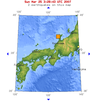
The 2007 Noto earthquake occurred on March 25, 2007, in the Hokuriku region of Japan.
On February 4, 1975 at 19:36 CST, an earthquake of 7.5 and intensity (MMI) IX hit the city of Haicheng, Liaoning, China. Much of the city was evacuated before the earthquake, so few died from building collapse, however, many died from fire and hypothermia in the subsequent days. The evacuees lived during the deep winter in self-made tents made of tree branches, bed sheets, tarps and straw, 372 froze to death and 6,578 suffered frostbite, while a fire burned 341 to death and 980 suffered non-fatal burns. The fire was one of the most notable earthquake-induced fires in China, triggered from a combination of cooking, winter heating and lighting.

On June 14, the 2008 Iwate earthquake struck the Tōhoku region of northeastern Honshū in Japan. Japan Meteorological Agency (JMA) officially named this earthquake the Iwate–Miyagi Nairiku earthquake in 2008. This earthquake occurred in the south of the inland of Iwate Prefecture at 8:43 JST on June 14. The JMA magnitude was estimated at MJMA 7.2, and the moment magnitude by USGS was at 6.9. The epicenter was located at 39°01.7′N140°52.8′E, about 85 kilometres (55 mi) north of Sendai and about 385 kilometres (240 mi) north-northeast of Tokyo.

In Japan, the Earthquake Early Warning (EEW) is a warning issued when an earthquake is detected by multiple seismometers. These warnings are primarily issued by the Japan Meteorological Agency (JMA), with guidance on how to react to them.
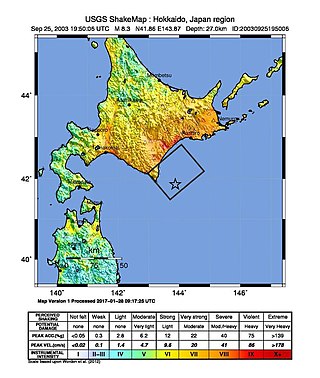
The 2003 Hokkaidō earthquake, scientifically named the 2003 Tokachi-Oki earthquake, occurred off the coast of Hokkaidō, Japan on 26 September at 04:50 local time. At a focal depth of 27 km (17 mi), this great undersea earthquake measured 8.3 on the moment magnitude scale, making it the most powerful earthquake of 2003, as well as one of the most intense earthquakes to hit Japan since modern record-keeping began in 1900.

The 1948 Fukui earthquake occurred in Fukui Prefecture, Japan. The magnitude 6.8 quake struck at 5:13:31 p.m.(JDT) on June 28, 1948. The quake's hypocenter was approximately 10 km north-northeast of Fukui, in the present-day neighborhood of Maruoka, Sakai City. The strongest shaking occurred in the city of Fukui, where it was recorded as 6 on the Japan Meteorological Agency seismic intensity scale.
The 1964 Niigata earthquake struck at 13:01 local time on 16 June with a magnitude of either 7.5 or 7.6. The epicenter was on the continental shelf off the northwest coast of Honshu, Japan in Niigata Prefecture, about 50 kilometres (31 mi) north of the city of Niigata. The earthquake caused liquefaction over large parts of the city.

The 1984 Nagano earthquake hit the western part of Nagano Prefecture, Japan on September 14, 1984, at 08:48 local time. Registering a magnitude of 6.3, the earthquake destroyed Otaki, and triggered major landslides. The earthquake left at least 29 people dead or missing, making it the deadliest earthquake in 1984.
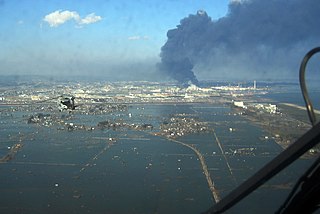
On 11 March 2011, at 14:46 JST, a 9.0–9.1 undersea megathrust earthquake occurred in the Pacific Ocean, 72 km (45 mi) east of the Oshika Peninsula of the Tōhoku region. It lasted approximately six minutes, causing a tsunami. It is sometimes known in Japan as the "Great East Japan Earthquake", among other names. The disaster is often referred to as simply 3.11.
A potent magnitude 6.6 Mw intraplate aftershock occurred at 17:16 JST (08:16 UTC) on 11 April, in the Hamadōri region of Fukushima, Japan. With a shallow focus of 13 km (8.1 mi), the earthquake was centred inland about 36 km (22 mi) west of Iwaki, causing widespread strong to locally severe shaking. It was one of many aftershocks to follow the 11 March Tōhoku earthquake, and the strongest to have its epicentre located inland.
The 1994 Kuril Islands earthquake – also known as the Hokkaido Toho-oki earthquake – occurred on . The magnitude of this earthquake was put at 8.3, or 8.1. The epicenter was located at about 70 km east of Shikotan Island. The shaking and tsunami caused road and building damage. At least 10 people were reported dead.
The 1930 North Izu earthquake occurred on . The epicenter was located in the northern Izu Peninsula, Japan. It had a magnitude of 7.3, and was caused by the movement of the Tanna Fault (丹那断層).

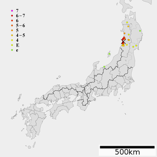
The 1894 Shōnai earthquake is an earthquake occurred on October 22, 1894 at Sakata, Yamagata Prefecture in Japan. It was caused by the movement of the Shonai Plain Eastern Margin Fault Zone (庄内平野東縁断層帯).
The 1925 North Tajima earthquake occurred on May 23, 1925 at Toyooka, Hyōgo in Japan.

The 2011 Nagano earthquake was an earthquake that occurred near the border between Niigata and Nagano prefectures at 3:59 JST on March 12, 2011. The depth of the hypocenter was 8 km and magnitude of the earthquake was 6.7.

The July 2008 Iwate earthquake was an earthquake that occurred in Iwate Prefecture, Japan on July 23, 2008. The earthquake's moment magnitude was 6.8 and it occurred at a depth of 115 km. Since this earthquake was an intermediate-focus earthquake, the shaking of the earthquake was observed over a wide range. It had a maximum JMA intensity of Shindo 6− .
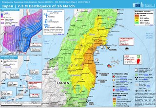
On March 16, 2022, at 23:36 JST, a strong earthquake struck off the coast of Fukushima, Japan. The earthquake had a magnitude of 7.4 according to the Japanese Meteorological Agency (JMA), while the United States Geological Survey (USGS) gave an estimate of 7.3. Immediately after the event a 30‑cm tsunami was reported. The event is known in Japanese as Fukushima-ken Oki Jishin. As a result of this natural disaster, three people died and 247 were injured.
The 1804 Kisakata earthquake struck Dewa Province, Japan on July 10 with a magnitude of 7.0. The earthquake killed 300–500 people. Nearby Mount Chokai erupted at about the same time as the earthquake. Lake Kisakata was uplifted by the earthquake, so Kisakata, featured in Bashō's Oku no Hosomichi, became new land and a swamp. A 1 m tsunami flooded 300 homes in Kisakata and Sakata.
