
Meghalaya is a state in northeast India. Meghalaya was formed on 21 January 1972 by carving out two districts from the state of Assam: (a) the United Khasi Hills and Jaintia Hills and (b) the Garo Hills. The population of Meghalaya as of 2014 is estimated to be 3,211,474. Meghalaya covers an area of approximately 22,429 square kilometres, with a length-to-breadth ratio of about 3:1.

Bastar is a district in the state of Chhattisgarh in Central India. Jagdalpur is the district headquarters. Bastar is bounded on the northwest by Narayanpur District, on the north by Kondagaon district, on the east by Nabarangpur and Koraput Districts of Odisha State, on the south and southwest by Dantewada and Sukma. The district possesses a unique blend of tribal and Odia culture.
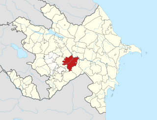
Aghjabadi District is one of the 66 districts of Azerbaijan. It is located in the centre of the country and belongs to the Aran Economic Region. The district borders the districts of Khojavend, Agdam, Barda, Zardab, Beylagan, and Fuzuli. Its capital and largest city is Aghjabadi. As of 2020, the district had a population of 136,800.

Simdega is a city in the Indian state of Jharkhand. Simdega is the administrative headquarters of the eponymous district and Subdivision. The city stands at an elevation of approximately 418 metres (1371 feet) above sea level and covers an area of 3,750 km2 (1,450 sq mi). Bounded in the north by Gumla, on the east by Ranchi and West Singhbhum, on the west by Jashpur Nagar, Chhattisgarh and on the south by Rourkela, Odisha. The distance between Rourkela and Simdega is 83 km. It is accessible by road through National Highways from Rourkela and Ranchi. The nearest railway station is Bano railway station.

Chifeng, also known as Ulanhad, is a prefecture-level city in Southeastern Inner Mongolia, People's Republic of China. It borders Xilin Gol League to the north and west, Tongliao to the northeast, Chaoyang (Liaoning) to the southeast and Chengde (Hebei) to the south. The city has a total administrative area of 90,275 square kilometres (34,855 sq mi) and as of the 2020 census, had a population of 4,035,967 inhabitants. However, 1,175,391 of those residents lived in the built-up area made of the 2 urban districts of Hongshan and Songshan, as Yuanbaoshan is not conurbated yet. However, a large part of Songshan is still rural and Yuanbaoshan is a de facto separate town 27 kilometers away from the core district of Chifeng. The city was the administrative center of the defunct Ju Ud League.

Baglung District, a part of Gandaki Province, is one of the seventy-seven districts of Nepal. The district, with Baglung as its district headquarters, covers an area of 1,784 km2 (689 sq mi) and has a population (2011) of 268,613.

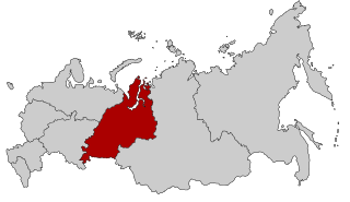
Ural is a geographical region located around the Ural Mountains, between the East European and West Siberian plains. It is considered a part of Eurasian Steppe, extending approximately from the North to the South; from the Arctic Ocean to the end of the Ural River near Orsk city. The border between Europe and Asia runs along the Eastern side of the Ural Mountains. Ural mostly lies within Russia but also includes a small part of Northwestern Kazakhstan. This is historical, not an official entity, with borders overlapping its Western Volga and Eastern Siberia neighboring regions. At some point in the past, parts of the currently existing Ural region were considered a gateway to Siberia, or even Siberia itself, and were combined with the Volga administrative the divisions. Today, there are two official namesake entities: the Ural Federal District and the Ural economic region. While the latter follows the historical borders, the former is a political product; the District omits Western Ural and includes Western Siberia instead.

Baglung is a municipality in Gandaki Province, in western Nepal, 275 km (171 mi) west of Kathmandu. It is the administrative headquarters of Baglung District. Baglung serves as the major center for business, finance, education, service and healthcare for the people of mid-Kali Gandaki valley that encompass Beni, Jaljala, Baglung, Kushma, Kathekhola, Galkot, Phalewas and Jaimuni local bodies. The city is located at the cross-section of Kaligandaki corridor highway and midhill highway that transverse Nepal in north–south and east–west directions respectively.
Dhorpatan is a municipality in Nepal's Baglung District, 3,900 meters elevation in an east–west valley south of the Dhaulagiri mountain range in the Himalayas. It is the headquarters of Dhorpatan Hunting Reserve. There is a small community of indigenous Kham Magar people as well as Tibetan refugees.

The New Guinea Highlands, also known as the Central Range or Central Cordillera, is a long chain of mountain ranges on the island of New Guinea, including the island's tallest peak, Puncak Jaya, Indonesia, 16,024 ft (4,884 m), the highest mountain in Oceania. The range is home to many intermountain river valleys, many of which support thriving agricultural communities. The highlands run generally east-west the length of the island, which is divided politically between Indonesia in the west and Papua New Guinea in the east.

The Churu people are a Chams related ethnic group living mainly in Lâm Đồng, and Bình Thuận provinces of Central Vietnam. They speak Chru, a Malayo-Polynesian language. The word Churu means Land Expander in their language. The Churu's population was 23,242 in 2019.
Amalachaur is a village development committee in Baglung District in the Dhaulagiri Zone of central Nepal. At the time of the 1991 Nepal census it had a population of 5,055 and had 943 houses.
Burtibang is a village development committee in Baglung District in the Dhaulagiri Zone of central Nepal. Burtibang is the second-largest commercial city in the district after Baglung.
The Chhantyal are an indigenous people of Nepal. Chhantyals are considered an indigenous group by the Government of Nepal. Most of the Chhantyal dwellings are concentrated in the western part of the country. Baglung and Myagdi are two districts in the Dhaulagiri Zone where most of the Chhantyals are living. Other districts with Chhantyal habitation include Mustang, Gulmi, Rukum, and Parbat. Nowadays, owing to the migration trend there is a notable population of the Chhantyals in Kathmandu Valley, Pokhara, Rupandehi, Kaski, Dang and Chitwan districts. According to a survey conducted by its sole organization, Nepal Chhantyal Organization, the total population is 16,093 and 1,602 households. Traditionally Chhantyals have been living with other castes in harmony. In some villages Chhantyals are a major group whereas in other villages they are a minority. Chhantyals have their own culture, tradition, rituals, language, and religion.
The Madhya Pradesh Rural Livelihoods Project (MPRLP) works with local village assemblies, Gram Sabha, to facilitate and guide community-driven collective and individual action to reduce poverty in the state of Madhya Pradesh, India.
Jalukie is a town in the Peren District of the Indian state of Nagaland. According to the 2011 census of India, Jalukie has a population of 8,706. Jalukie is a planned urban area developed to serve the growing urban population in Nagaland.
Galkot is a municipality in Baglung district of Gandaki province of Nepal. It consists of several VDCs. Nearby cities include Gulmi and Pokhara. Its geographic coordinates are 28°13'24"N 83°25'29"E.

Reindeer herding is when reindeer are herded by people in a limited area. Currently, reindeer are the only semi-domesticated animal which naturally belongs to the North. Reindeer herding is conducted in nine countries: Norway, Finland, Sweden, Russia, Greenland, Alaska, Mongolia, China and Canada. A small herd is also maintained in Scotland.
Annapurna Rural Municipality, Kaski is a Gaunpalika in Kaski District in Gandaki Province of Nepal named after the Annapurna Mountain. On 12 March 2017, the Government of Nepal implemented a new local administrative structure. With the implementation of the new local administrative structure, VDSs have been replaced with Municipal and Village Councils. Annapurna Gaupalika is one of these 753 local units.


