
Baglung District, a part of Gandaki Province, is one of the seventy-seven districts of Nepal. The district, with Baglung as its district headquarters, covers an area of 1,784 km2 (689 sq mi) and has a population (2011) of 268,613.
Bajura District, a part of Sudurpashchim Province, is one of the seventy-seven districts of Nepal. The district, with Martadi as its district headquarters, covers an area of 2,188 km2 (845 sq mi) and had a population of 108,781 in 2001 and 134,912 in 2011.
Kohalpur is a municipality in Banke District of Lumbini province of Nepal. The municipality was established on 18 May 2014 merging the existing two Village Development Committees i.e. Rajhena and Kohalpur. The town is in East-West highway and one of the fastest developing places in Nepal. A neighboring city Nepalgunj is on South (16 km [9.9 mi]), with Ghorahi city (135 km [84 mi]) to west in Dang District and further 6 km (3.7 mi) is the Indian border. In fact it is a growing city in the western region of Nepal. It has a junction to diverse the roadway transport to east, west, north and south from the city.
Amalachaur is a village development committee in Baglung District in the Dhaulagiri Zone of central Nepal. At the time of the 1991 Nepal census it had a population of 5,055 and had 943 houses.
Amarbhumi is a village development committee in Baglung District in the Dhaulagiri Zone of central Nepal. At the time of the 1991 Nepal census it had a population of 2,248 and had 409 houses in the village. It has been reported that the villagers of Amarbhumi VDC in Baglung district have changed their village's name to Mulabari.
Burtibang is a village development committee in Baglung District in the Dhaulagiri Zone of central Nepal. Burtibang is the second-largest commercial city in the district after Baglung.
Damek is a village development committee in Baglung District in the Dhaulagiri Zone of central Nepal. At the time of the 1991 Nepal census it had a population of 5,824 and had 1072 houses in the town.
Narayansthan is a village development committee in Baglung District in the Dhaulagiri Zone of central Nepal.It is located above the bank of Kali gandaki River. Now, it has become one of the major important place in baglung. They have planned to construct the domestic Airport. At the time of the 2011 Nepal census it had a population of 2,876 and had 781 houses in the town. The major castes living in the VDC are Brahman, Chhetry and Newar. There are 2 high schools - Janatadhan Higher School and Ganesh Secondary School and one campus. Krishna Gandaki Campus is at the premises of Janatadhan HSS. Ganesh Secondary School, one of the best schools in the region is known for its quality education movement. Established in 1957 [2014 BS] by Soldier Board (India), Ganesh Secondary School is one of the oldest schools. In 1964 [2021 BS], the Indian Soldier Board stopped its grant. Since there was no school support mechanism developed from the Government of Nepal, the school passed through many ups and downs. After Modern Education Act came in effect in 1971 BS [2028 BS], the school merged with Janatadhan Higher Secondary School. In 1980 [2037 BS], the school was reopened.
Sangrumba साङरुम्बा is a town and Village Development Committee in Ilam District in the Province No. 1 of eastern Nepal. At the time of the 1991 Nepal census it had a population of 4,607 persons living in 839 individual households. According to the VDC report of 2068 BS, the total population was 6,288 and the total number of households was 1,227, an average of 5.12 members per household.
Jijodamandau is a village development committee in Doti District in the Seti Zone of western Nepal. At the time of the 1991 Nepal census it had a population of 1906 living in 365 individual households.
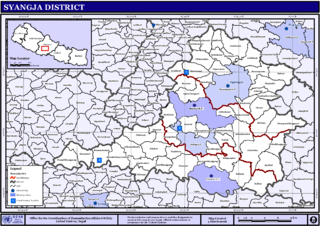
Banethok Deurali is a village development committee in Syangja District in the Gandaki Zone of central Nepal. At the time of the 2011 Nepal census it had a population of 3,546 people living in 864 individual households. The VDC is situated eight miles from district headquarters Syangja Bazaar. Siddhartha National Highway is the closest national highway to this VDC. With nearly 95% literate population, this VDC has one higher secondary school, one lower secondary school, four primary schools and one English medium school.
Sanghutar is a village development committee in Ramechhap District in the Janakpur Zone of north-eastern Nepal. At the time of the 1991 Nepal census it had a population of 2,177 people living in 394 individual households. The VDC has a small market called Sanghutar Bazaar, situated in the bank of the Likhu River and bordering Okhaldhunga District. The bazaar is flat land near to the bridge ; therefore, its name is Sanghutar. It is a main commercial center of many neighboring villages of Ramechhap and Okhaldhunga District with a higher secondary school called Himaganga.
Tikhatar is a village development committee in Doti District in the Seti Zone of western Nepal. At the time of the 1991 Nepal census it had a population of 5222 people in 958 individual households.

Pakhribas is an urban municipality out of three urban municipalities located in Dhankuta District of Province No. 1 of Nepal. Pakhribas municipality established on 2 December 2014 merging following VDCs: Pakhribas, Sanne, Phalate, Ghorlikharka and Muga.

Surunga is a trade center of Jhapa District. It is located in Kankai Municipality in Jhapa District in the Province No. 1 of south-eastern Nepal. At the time of the 1991 Nepal census it had a population of 16,747 people living in 2996 individual households. Surunga is one of the rapidly developing towns of Jhapa district. It is situated on the bank of the Kankai River.
Gunjanagar is a town in Bharatpur, Chitwan in Bagmati Province of southern Nepal. The former Gunjanagar VDC and Saradanagar VDC were merged on 18 May 2014 to form new Chitrawan Municipality, which later was merged with Bharatpur. At the time of the 1991 Nepal census it had a population of 11,076 people living in 2025 individual households.
Paiyunthantap is one of the village development committees of Baglung district, in the Dhaulagiri Zone of Nepal. It lies in the southern belt of the district. Paiyunthantap borders with Sarkuwa in the south-east, Rangkhani in the south and west and Damek in the east and north.
Pindikhola was a village development committee in Syangja District in the Gandaki Zone of central Nepal. At the time of the 2011 Nepal census it had a population of 4,956 people living in 1,119 individual households.
Giruwari is one of the village located in north part of Nawalparasi district of Lumnini Zone in the western development region of Nepal. Lumbinī is a Buddhist pilgrimage site in the Rupandehi district of Nepal.[1] It is the place where Queen Mayadevi gave birth to Siddhartha Gautama, who is the Buddha. Gautama founded the Buddhist tradition. Buddha lived between roughly 563 and 483 BC. Lumbini is one of four magnets for pilgrimage that sprang up in places pivotal to the life of the Buddha, the others being at Kushinagar, Bodh Gaya and Sarnath.
Jaidi is a development committees of Baglung District of Gandaki Province, situated in western Nepal. Jaidi is situated in the southern part of Baglung district. It is surrounded by Chisti, Kiwai, Byarthala, Sarkuwa and Arjewa Village Development Committees. According to the census of 2011. this VDC have more than 1000 households. The VDC is again divided into smaller villages called Ward, and it has 9 different Ward within VDC.


